
-
Federal
AfriSAR: Polarimetric Height Profiles by TomoSAR, Lope and Rabi Forests, Gabon, 2016
National Aeronautics and Space Administration —
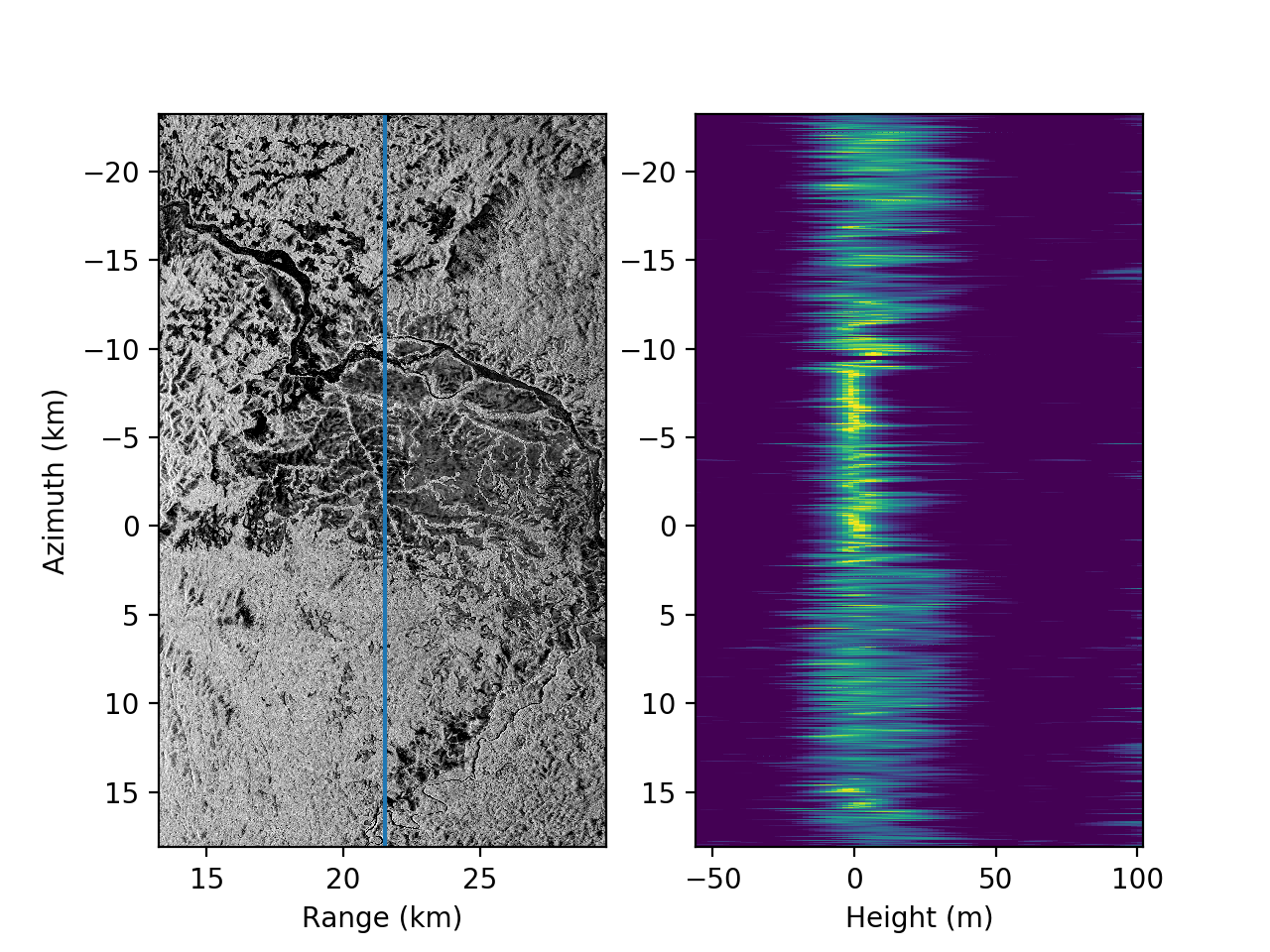
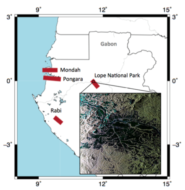
This dataset provides height profiles derived from UAVSAR (Uninhabited Aerial Vehicle Synthetic Aperture Radar; JPL) data acquired over Lope National Park and Rabi... -
Federal
AfriSAR: Canopy Structure Derived from PolInSAR and Coherence TomoSAR NISAR tools
National Aeronautics and Space Administration —
This dataset contains forest vertical structure and associated uncertainty products derived by applying multi-baseline Polarimetric Interferometric Synthetic Aperture... -
Federal
Delta-X: AirSWOT L3 Water Surface Elevations, MRD, Louisiana, 2021, Version 2
National Aeronautics and Space Administration —
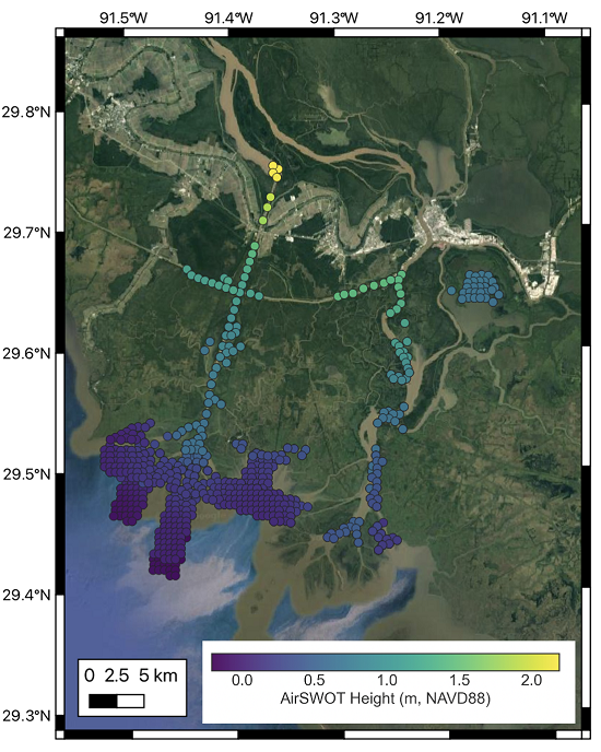
This dataset contains water surface elevations at selected point locations generated from the AirSWOT data collected during the Spring and Fall 2021 Delta-X... -
Federal
ABoVE: Synthesis of Burned and Unburned Forest Site Data, AK and Canada, 1983-2016
National Aeronautics and Space Administration —
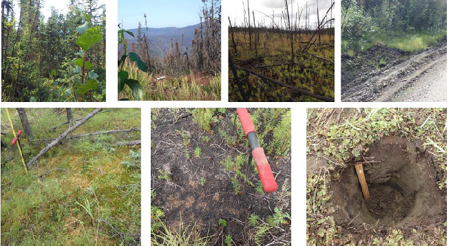
This dataset is a synthesis of field plot characterization data, derived above-ground and below-ground combusted carbon, and acquired Fire Weather Index (FWI) System... -
Federal
ABoVE: Characterization of Burned and Unburned Spruce Forest Sites, Tanana, AK, 2017
National Aeronautics and Space Administration —
This dataset provides the results of field observations of soil characteristics and depth to permafrost, survey results for Composite Burn Index (CBI) determination,... -
Federal
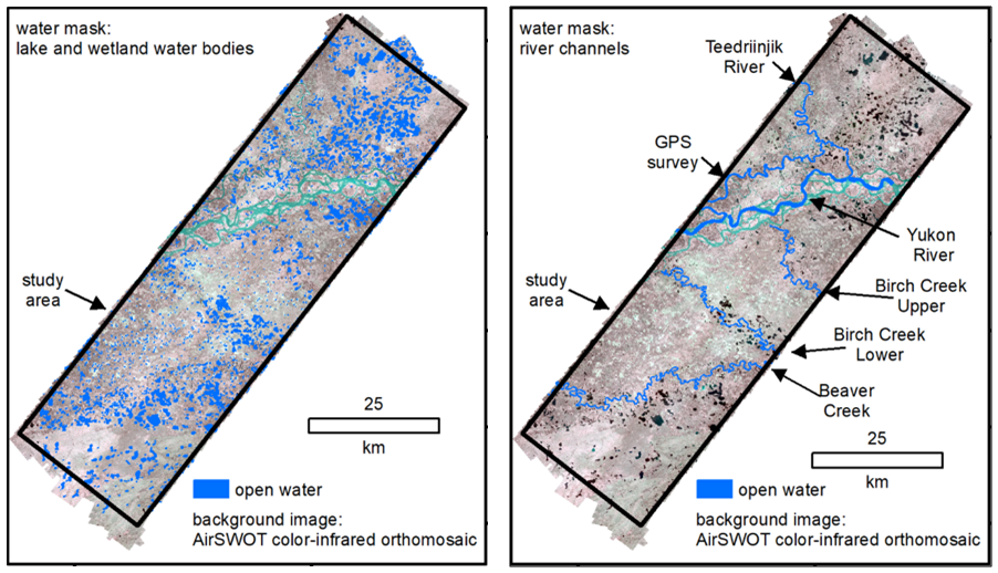
ABoVE: AirSWOT Radar, Orthomosaic, and Water Masks, Yukon Flats Basin, Alaska, 2015
National Aeronautics and Space Administration —
This dataset provides NASA AirSWOT Ka-band (35.75 GHz) radar interferometry data products for water surface elevation (WSE), a derived color-infrared (CIR) digital... -
Federal
Arctic Vegetation Plots at Umiat, North Slope, Alaska, 1951
National Aeronautics and Space Administration —
This data set provides vegetation cover and plot data collected during the periods of July and August, 1951, from 51 stands (areas of homogeneous vegetation... -
Federal
Arctic Vegetation Plots, Poplars, Arctic and Interior AK and YT, Canada, 2003-2005
National Aeronautics and Space Administration —
This data set provides vegetation cover and environmental plot data collected from 32 balsam poplar (Populus balsamifera L., Salicaceae) vegetation plots located on... -
Federal
Geospatial data for the Vegetation Mapping Inventory Project of Gila Cliffs Dwellings National Monument
Department of the Interior —
The files linked to this reference are the geospatial data created as part of the completion of the baseline vegetation inventory project for the NPS park unit.... -
Federal
H13969: NOS Hydrographic Survey , 2024-09-23
National Oceanic and Atmospheric Administration, Department of Commerce —
The National Oceanic and Atmospheric Administration (NOAA) has the statutory mandate to collect hydrographic data in support of nautical chart compilation for safe... -
Federal
Bathymetric Position Index (BPI) Zones 10 m grid derived from gridded bathymetry of Alamagan Island, Commonwealth of the Northern Mariana Islands, USA.
National Oceanic and Atmospheric Administration, Department of Commerce —
BPI Zones are derived from a focal mean analysis on bathymetry and slope. The grid is based on gridded (10 m cell size) multibeam bathymetry, collected aboard NOAA... -
Federal
H11866: NOS Hydrographic Survey , West of Prince of Wales Island, Alaska, 2008-09-04
National Oceanic and Atmospheric Administration, Department of Commerce —
The National Oceanic and Atmospheric Administration (NOAA) has the statutory mandate to collect hydrographic data in support of nautical chart compilation for safe... -
Federal
H11994: NOS Hydrographic Survey , Icy Bay, Alaska, 2008-10-08
National Oceanic and Atmospheric Administration, Department of Commerce —
The National Oceanic and Atmospheric Administration (NOAA) has the statutory mandate to collect hydrographic data in support of nautical chart compilation for safe... -
Federal
H11488: NOS Hydrographic Survey , Southwestern Alaska Peninsula-Pavlof Islands, Alaska, 2005-08-12
National Oceanic and Atmospheric Administration, Department of Commerce —
The National Oceanic and Atmospheric Administration (NOAA) has the statutory mandate to collect hydrographic data in support of nautical chart compilation for safe... -
Federal
H11917: NOS Hydrographic Survey , Chatham Strait, Alaska, 2008-06-17
National Oceanic and Atmospheric Administration, Department of Commerce —
The National Oceanic and Atmospheric Administration (NOAA) has the statutory mandate to collect hydrographic data in support of nautical chart compilation for safe... -
Federal
H11852: NOS Hydrographic Survey , West of Prince of Wales Island, Alaska, 2008-11-09
National Oceanic and Atmospheric Administration, Department of Commerce —
The National Oceanic and Atmospheric Administration (NOAA) has the statutory mandate to collect hydrographic data in support of nautical chart compilation for safe... -
Federal
H11590: NOS Hydrographic Survey , Canaveral-Ponce De Leon, Florida, 2007-08-16
National Oceanic and Atmospheric Administration, Department of Commerce —
The National Oceanic and Atmospheric Administration (NOAA) has the statutory mandate to collect hydrographic data in support of nautical chart compilation for safe... -
Federal
H11844: NOS Hydrographic Survey , Approaches to Sitka, Alaska, 2008-06-18
National Oceanic and Atmospheric Administration, Department of Commerce —
The National Oceanic and Atmospheric Administration (NOAA) has the statutory mandate to collect hydrographic data in support of nautical chart compilation for safe... -
Federal
H12000: NOS Hydrographic Survey , West of Prince of Wales Island, Alaska, 2008-11-09
National Oceanic and Atmospheric Administration, Department of Commerce —
The National Oceanic and Atmospheric Administration (NOAA) has the statutory mandate to collect hydrographic data in support of nautical chart compilation for safe... -
Federal
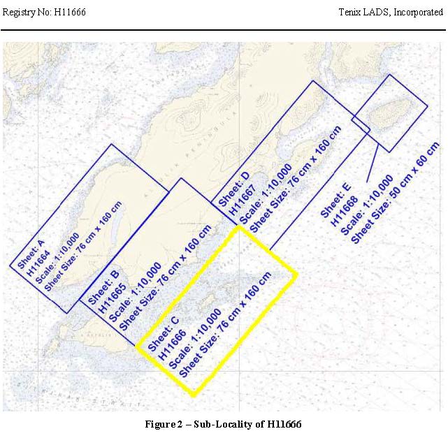
H11666: NOS Hydrographic Survey , Southeast Coast of Kodiak Island, Alaska, 2007-06-21
National Oceanic and Atmospheric Administration, Department of Commerce —
The National Oceanic and Atmospheric Administration (NOAA) has the statutory mandate to collect hydrographic data in support of nautical chart compilation for safe...

Official websites use .gov
A
.gov website belongs to an official government
organization in the United States.
Secure .gov websites use HTTPS
A
lock (
) or https:// means you’ve safely connected to
the .gov website. Share sensitive information only on official,
secure websites.
.jpg)
.jpg)