

2,921 datasets found
-
Federal
Forest Health Protection Tree Species Metrics Stand Density Index
Department of Agriculture —
These data are a product of a multi-year effort by the FHTET (Forest Health Technology Enterprise Team) Remote Sensing Program to develop raster datasets of forest... -
Federal
EnviroAtlas - Average annual soil loss and sediment yield to waterbodies by 12-digit HUC for the Conterminous United States
U.S. Environmental Protection Agency —
This EnviroAtlas national dataset shows the average annual soil loss and sediment yield to waterbodies by 12-digit HUC subwatershed for the conterminous United States... -
Federal
EnviroAtlas - Average Annual Sediment Delivery Ratio (Scaled) - Existing Land Use / Land Cover Scenario for the Conterminous United States
U.S. Environmental Protection Agency —
This EnviroAtlas national dataset shows the average sediment delivery ratio (SDR) - the percentage of soil eroding from a pixel that is transported to a downstream... -
Federal
The StreamCat Dataset: Accumulated Attributes for NHDPlusV2 (Version 2.1) Catchments for the Conterminous United States: Mine Density Active Mines and Mineral Plants in the US
U.S. Environmental Protection Agency —
This dataset represents the mine density within individual, local NHDPlusV2 catchments and upstream, contributing watersheds based on mine plants and operations... -
Federal
Certification Plan and Reporting Database (CPARD)
U.S. Environmental Protection Agency —
CPARD contains (1) EPA-approved State, Tribal and Federal certification plans required by the Federal Insecticide, Fungicide, Rodenticide Act to administer a... -
Federal
EnviroAtlas - Dasymetric Population in the Conterminous United States Web Service
U.S. Environmental Protection Agency —
This EnviroAtlas web service supports research and online mapping activities related to EnviroAtlas (https://www.epa.gov/enviroatlas). This EnviroAtlas dataset... -
Federal
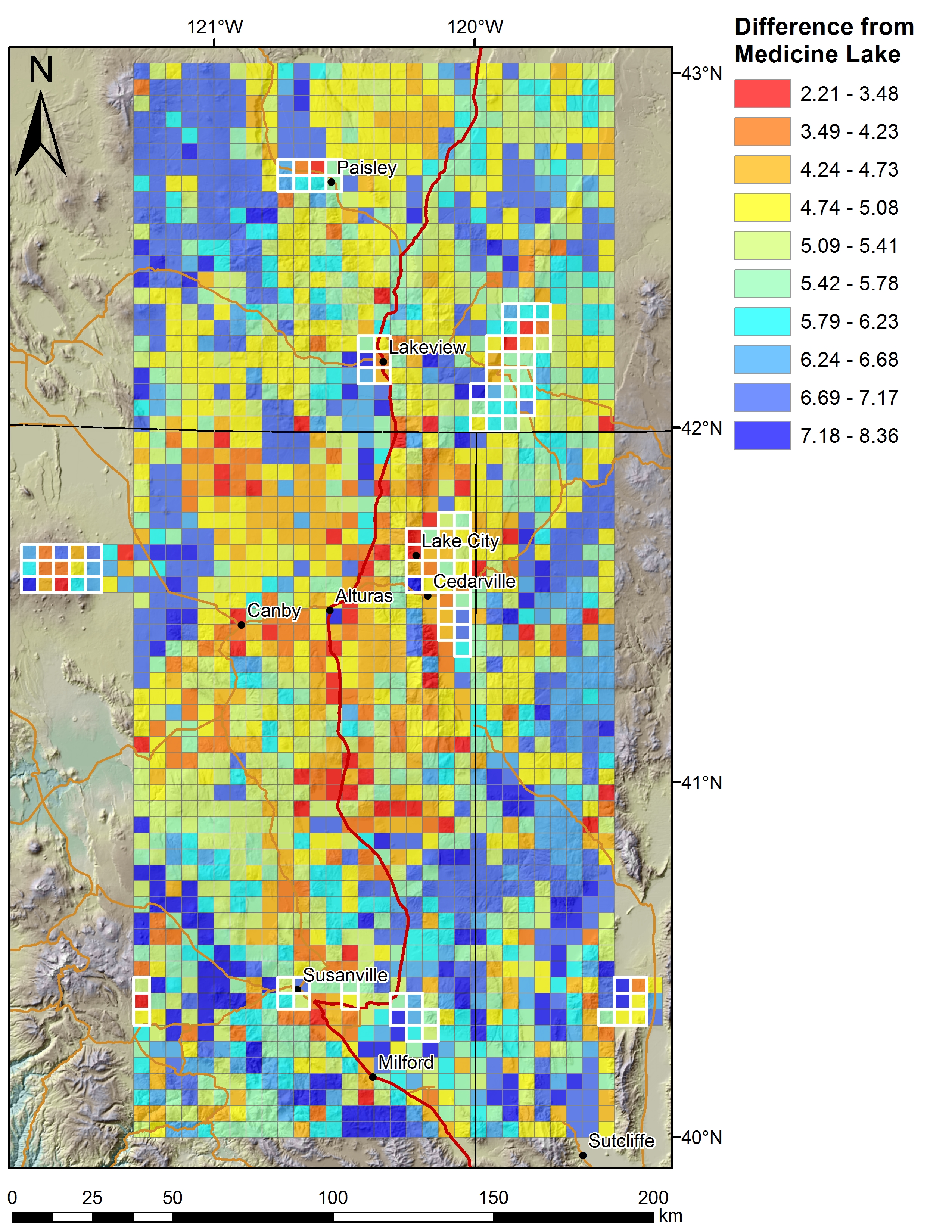
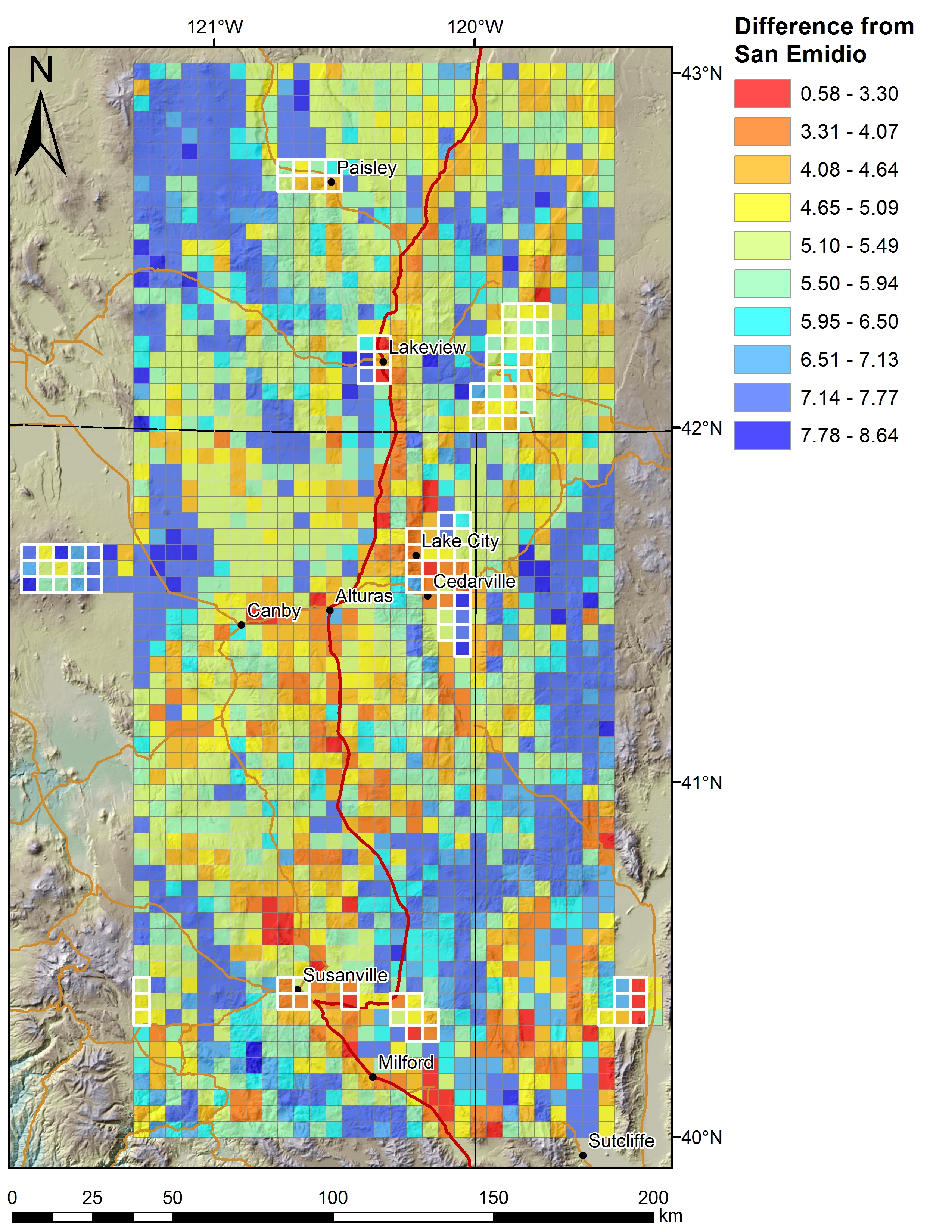
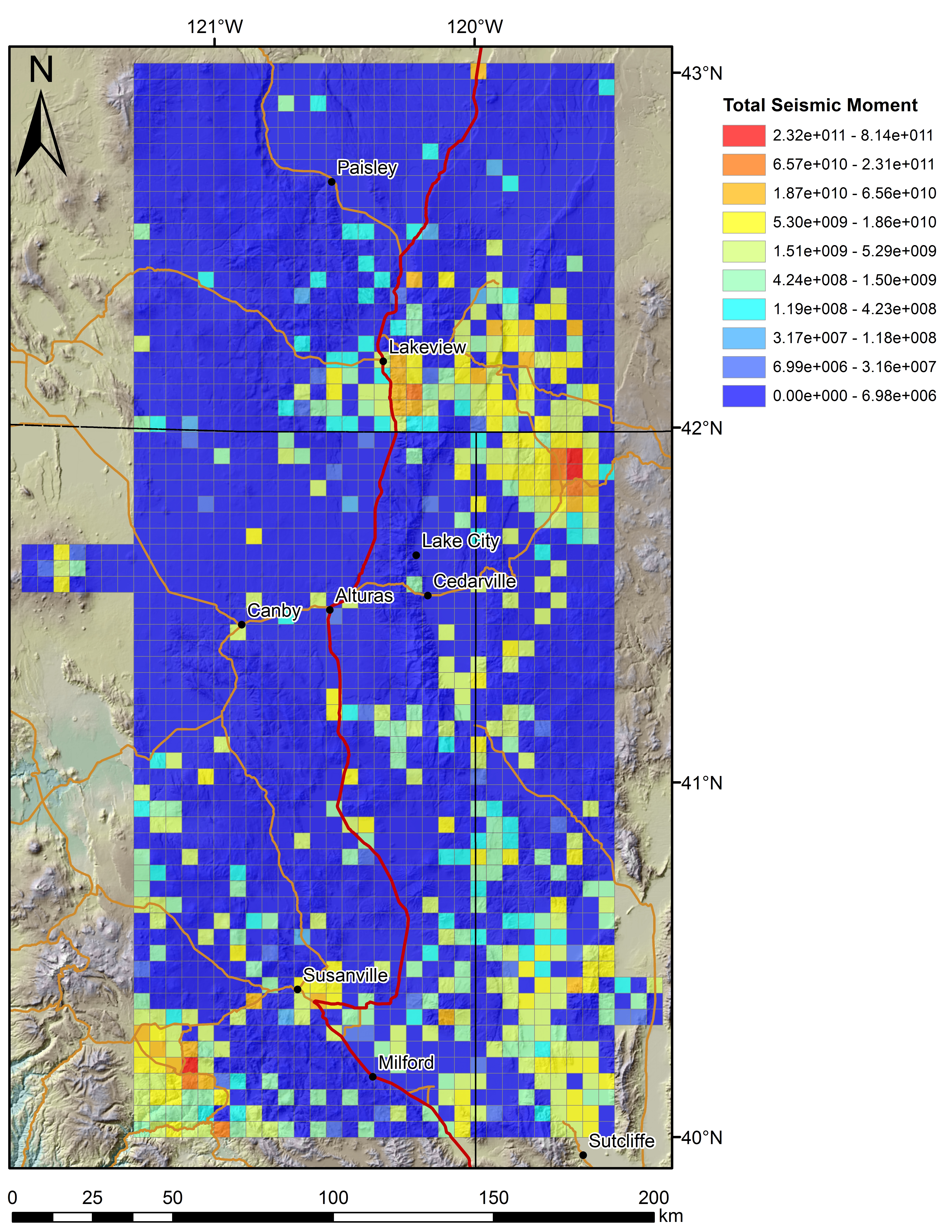
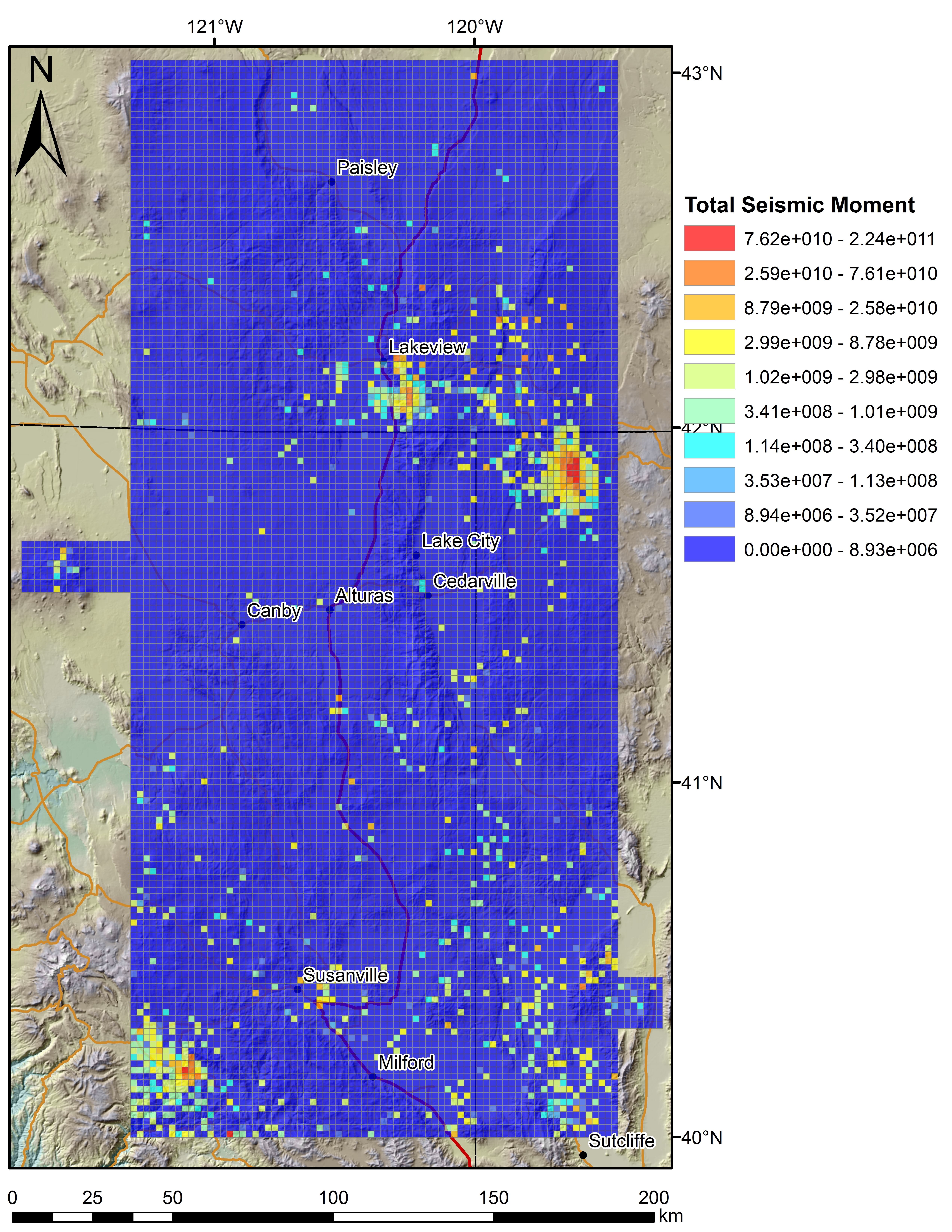
Play Fairway Analysis CA-NV-OR: Figures on 2km Grids
Department of Energy —
Various data sets displayed on a 2km grid for the Play Fairway Analysis CA-NV-OR area. -
Federal
The StreamCat Dataset: Accumulated Attributes for NHDPlusV2 (Version 2.1) Catchments for the Conterminous United States: Surficial Lithology in Watershed
U.S. Environmental Protection Agency —
This dataset represents the density of 18 USGS lithology classes within individual, local NHDPlusV2 catchments and upstream, contributing watersheds(see Data Sources... -
Federal
EPA Facility Registry Service (FRS): ER_TSCA
U.S. Environmental Protection Agency —
This web feature service contains location and facility identification information from EPA's Facility Registry System (FRS) for the subset of facilities that link to... -
Federal
TIGER 2010 Boundaries
U.S. Environmental Protection Agency —
This EnviroAtlas web service supports research and online mapping activities related to EnviroAtlas (https://www.epa.gov/enviroatlas). This web service includes the... -
Federal
EnviroAtlas - MSPA connectivity with water as background and 3-pixel edge width for the conterminous United States
U.S. Environmental Protection Agency —
This EnviroAtlas dataset categorizes land cover into structural elements (e.g. core, edge, connector, etc.). It depicts core areas of natural land cover, core... -
Federal
Brownfields/IGD: EF_ACRES
U.S. Environmental Protection Agency —
EF_ACRES is a subset of facilities from FRS_PROGRAM_FACILITY and associated best-available geospatial coordinates. Facility Registry Service (FRS) data are refreshed... -
Federal
EnviroAtlas - Dasymetric Population for the Conterminous United States
U.S. Environmental Protection Agency —
This EnviroAtlas dataset intelligently reallocates 2010 population from census blocks to 30 meter pixels based on land cover and slope. This dataset was produced by... -
Federal
BLM NV Grazing Allotments
Department of the Interior —
This polygon feature class represents the spatial extent and boundaries for BLM Grazing Allotments within the BLM Administrative State of Nevada. -
Federal
United States Documented Unplugged Orphaned Oil and Gas Well Dataset
Department of the Interior —
The United States Documented Unplugged Orphaned Oil and Gas Well (DOW) dataset contains 117,672 wells in 27 states. The definition of an orphaned oil or gas well... -
Federal
EnviroAtlas - Annual average potential wind energy resource by 12-digit HUC for the Conterminous United States
U.S. Environmental Protection Agency —
This EnviroAtlas dataset shows the annual average potential wind energy resource in kilowatt hours per square meter per day for each 12-digit Hydrologic Unit (HUC).... -
Federal
EnviroAtlas - Biological nitrogen fixation in natural/semi-natural ecosystems by 12-digit HUC for the Conterminous United States, 2006
U.S. Environmental Protection Agency —
This EnviroAtlas dataset contains data on the mean biological nitrogen fixation in natural/semi-natural ecosystems per 12-digit Hydrologic Unit (HUC) in 2006.... -
Federal
The StreamCat Dataset: Accumulated Attributes for NHDPlusV2 (Version 2.1) Catchments for the Conterminous United States: National Coal Resource Dataset System
U.S. Environmental Protection Agency —
This dataset represents the coal mine density and storage volumes within individual, local NHDPlusV2 catchments and upstream, contributing watersheds based on the... -
Federal
EnviroAtlas - Total number of vacant businesses by Census Tract for the Conterminous United States
U.S. Environmental Protection Agency —
This EnviroAtlas dataset portrays the total number of vacant business addresses for each Census Tract for each year from 2010-2014. Vacant buildings are included if... -
Federal
The StreamCat Dataset: Accumulated Attributes for NHDPlusV2 (Version 2.1) Catchments for the Conterminous United States: Wildland Fire Perimeters By Year 2000 - 2010
U.S. Environmental Protection Agency —
This dataset represents the historical fire perimeters within individual local NHDPlusV2 catchments and upstream, contributing watersheds based on the GeoMAC...
2,921 datasets found