
-
Federal
SAFARI 2000 Woody Vegetation Characteristics of Kalahari and Skukuza Sites
National Aeronautics and Space Administration —
This data set contains species composition, basal area, height, and crown cover of all woody plants at six sites along the Kalahari Transect visited in February-March... -
Federal
SAFARI 2000 1-Degree Estimates of Burned Biomass, Area, and Emissions, 2000
National Aeronautics and Space Administration —
A new method is used to generate spatial estimates of monthly averaged biomass burned area and spatial and temporal estimates of trace gas and aerosol emissions from... -
State
Wildland Urban Interface
State of California —
The current dataset is appropriate for displaying the overall pattern of WUI development at the county level, and comparing counties in terms of development patterns.... -
Urban Tree Canopy by Census Block Group in 2020
District of Columbia —
These data represent Census Block Groups 2020 in Washington, DC. Urban tree canopy (UTC) and possible planting area (PPA) metrics have been calculated for Census Block... -
DC Estimated Tree Root Zone (Critical)
District of Columbia —
The dataset is the estimate of a tree’s critical root zone, which can not be impacted beyond certain limits. Buffer distances are calculated for trees on all land... -
State
Tree Squirrel Hunt Zones [ds1343]
State of California —
Mapped hunt boundary is an approximation of regulations using best available data as of September 2015. Hunters are responsible for knowing the exact current boundary... -
Federal
BOREAS TE-06 Allometry Data
National Aeronautics and Space Administration —
The BOREAS TE-06 team collected several data sets in support of its efforts to characterize and interpret information on the plant biomass, allometry, biometry,... -
Federal
2024 IN DNR Lidar DEM: Indiana Coastline
National Oceanic and Atmospheric Administration, Department of Commerce —
Original Product: These are Digital Elevation Model (DEM) data as part of the required deliverables for the lidar project. Class 2 (Ground) lidar points in... -
Federal
Methods for Handling Missing Item Values in Regression Models Using the National Survey on Drug Use and Health (NSDUH)
U.S. Department of Health & Human Services —
The purpose of this report is to guide analysts interested in fitting regression models using data from the National Survey on Drug Use and Health (NSDUH) by... -
Federal
GEDI L4A Footprint Level Aboveground Biomass Density, Version 1
National Aeronautics and Space Administration —
This dataset contains Global Ecosystem Dynamics Investigation (GEDI) Level 4A (L4A) predictions of the aboveground biomass density (AGBD; in Mg/ha) and estimates of... -
Federal
CMS: LiDAR-derived Biomass, Canopy Height and Cover, Sonoma County, California, 2013
National Aeronautics and Space Administration —
This data set provides estimates of above-ground biomass (AGB), canopy height, and percent tree cover at 30-m spatial resolution for Sonoma County, California, USA,... -
Federal
Land Use and Cover Maps from Landsat, Mawas, Central Kalimantan, Indonesia, 1994-2019
National Aeronautics and Space Administration —
This dataset contains annual land use/cover (LUC) maps at 30 m resolution across Mawas, Central Kalimantan, Indonesia. There are six files, each representing a five-... -
Federal
Forest Inventory and Analysis Above Ground Forest Biomass (Image Service)
Department of Agriculture —
This Biomass and Carbon per Acre dataset was compiled for the 48-state CONUS Area in order to identify local, state and regional trends in forest cover and landscape... -
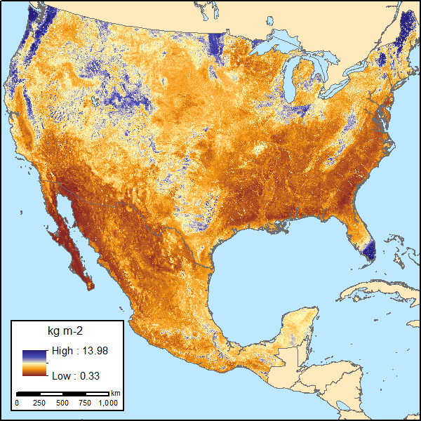
Federal
Soil Organic Carbon Estimates for 30-cm Depth, Mexico and Conterminous USA, 1991-2011
National Aeronautics and Space Administration —
This dataset provides two sets of gridded estimates of estimated soil organic carbon (SOC) and associated uncertainties for 0-30 cm topsoil layer in kg SOC/m2 at... -
Federal
GEDI L4A Footprint Level Aboveground Biomass Density, Version 2.1
National Aeronautics and Space Administration —
This dataset contains Global Ecosystem Dynamics Investigation (GEDI) Level 4A (L4A) Version 2 predictions of the aboveground biomass density (AGBD; in Mg/ha) and... -
University
Bark Beetle-caused Tree Mortality for the Stanley, Idaho Study Area
University of Idaho —
The downloadable ZIP file contains a georeferenced TIF. This raster layer is a supervised maximum likelihood classification of bark beetle-caused tree mortality based... -
Federal
2004 Maine Coastline LiDAR
National Oceanic and Atmospheric Administration, Department of Commerce —
This metadata document describes the collection and processing of Light Detection and Ranging (LIDAR) data over an area along the coast of Maine. Data was collected... -
Urban Tree Canopy by DC Owned Property in 2020
District of Columbia —
These data represent DC Owned Lots in Washington, DC. Urban tree canopy (UTC) and possible planting area (PPA) metrics have been calculated for DC Owned Lots within... -
Federal
H05387: NOS Hydrographic Survey , 1933-12-31
National Oceanic and Atmospheric Administration, Department of Commerce —
The National Oceanic and Atmospheric Administration (NOAA) has the statutory mandate to collect hydrographic data in support of nautical chart compilation for safe... -
Federal
H11854: NOS Hydrographic Survey , Columbia River, Oregon, 2009-03-05
National Oceanic and Atmospheric Administration, Department of Commerce —
The National Oceanic and Atmospheric Administration (NOAA) has the statutory mandate to collect hydrographic data in support of nautical chart compilation for safe...

Official websites use .gov
A
.gov website belongs to an official government
organization in the United States.
Secure .gov websites use HTTPS
A
lock (
) or https:// means you’ve safely connected to
the .gov website. Share sensitive information only on official,
secure websites.
.jpg)