
-
Federal
TOVS GLA 5 DAY GRIDS from NOAA-10 V01 (TOVSA5NG) at GES DISC recent views
National Aeronautics and Space Administration —
This dataset (TOVSA5NG) contains the TIROS Operational Vertical Sounder (TOVS) level 3 geophysical parameters derived using data from NOAA-10 and the physical... -
Federal
SAGE III/ISS L1B Monthly Solar Event Transmission Data (NetCDF) V052 recent views
National Aeronautics and Space Administration —
g3btmnc_52 is the Stratospheric Aerosol and Gas Experiment III (SAGE III) on the International Space Station (ISS) (SAGE III/ISS) Level 1 Monthly Solar Event Species... -
Federal
CERES Time-Interpolated TOA Fluxes, Clouds and Aerosols Daily NPP Edition2A recent views
National Aeronautics and Space Administration —
CER_SSF1deg-Day_NPP-VIIRS_Edition2A is the Clouds and the Earth's Radiant Energy System (CERES) Time-Interpolated Top of Atmosphere (TOA) Fluxes, Clouds and Aerosols... -
Federal
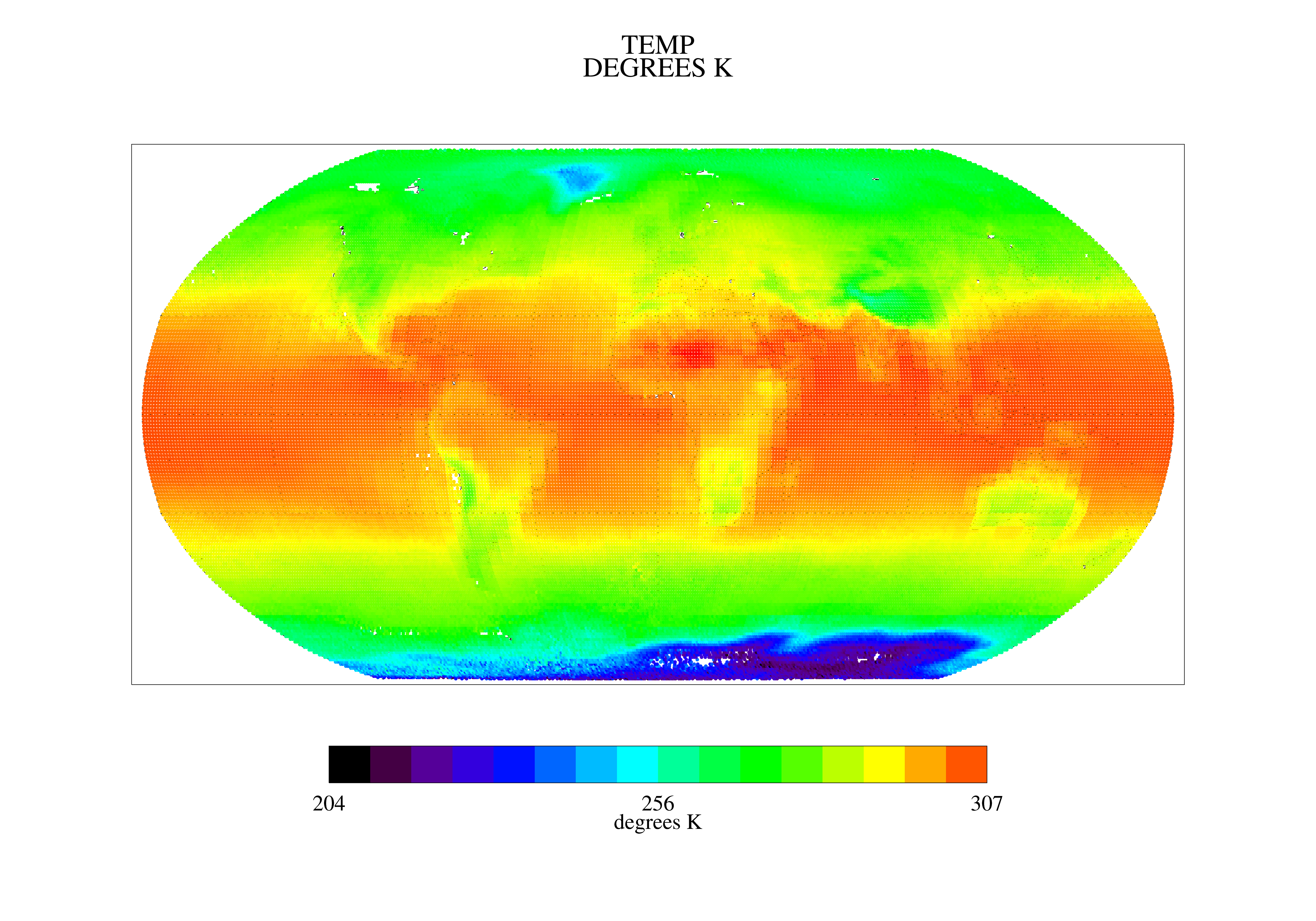
TOVS GLA MONTHLY GRIDS from TIROSN V01 (TOVSAMTN) at GES DISC recent views
National Aeronautics and Space Administration —
This dataset (TOVSAMTN) contains the TIROS Operational Vertical Sounder (TOVS) level 3 geophysical parameters derived using data from TIROSN and the physical... -
Federal
CAMEX-3 DC-8 METEOROLOGICAL MEASUREMENT SYSTEM (MMS) V1 recent views
National Aeronautics and Space Administration —
The CAMEX-3 Meteorological Measurement System (MMS) dataset consists of atmospheric parameters measured by the MMS instruments aboard NASA DC-8 aircraft. The MMS... -
Federal
First ISCCP Regional Experiment (FIRE) Atlantic Stratocumulus Transition Experiment (ASTEX) ECMWF Surface Data recent views
National Aeronautics and Space Administration —
A special set of analysis products for the Atlantic Stratocumulus Transition Experiment (ASTEX) region during June 1-28, 1992 was prepared by Ernst Klinker and Tony... -
Federal
GRIP DC-8 METEOROLOGICAL MEASUREMENT SYSTEM (MMS) V1 recent views
National Aeronautics and Space Administration —
The GRIP DC-8 Meteorological measurement System (MMS) dataset was collected by the Meteorological Measurement System (MMS), which provides high-resolution, accurate... -
Federal
GPM Ground Validation Advanced Vertical Atmospheric Profiling System (AVAPS) OLYMPEX V1 recent views
National Aeronautics and Space Administration —
The GPM Ground Validation Advanced Vertical Atmospheric Profiling System (AVAPS) OLYMPEX dataset contains dropsonde vertical profiles of atmospheric pressure, air... -
Federal
DISCOVER-AQ Maryland Deployment P-3B Aircraft In Situ Meteorological and Navigational Data recent views
National Aeronautics and Space Administration —
DISCOVERAQ_Maryland_MetNav_AircraftInSitu_P3B_Data contains in situ meteorological and navigational data collected onboard NASA's P-3B aircraft during the Maryland... -
Federal
NOAA Soundings IMPACTS V1 recent views
National Aeronautics and Space Administration —
The NOAA Soundings IMPACTS dataset was collected from January 1, 2020 through February 29, 2020 during the Investigation of Microphysics and Precipitation for... -
Federal
CAMEX-3 ANDROS ISLAND RAWINSONDE AND RADIOSONDES V1 recent views
National Aeronautics and Space Administration —
In support of CAMEX-3, numerous radiosonde and rawinsondes were launched from Andros Island, which consisted of instruments manufactured by VIS and Vaisala. Some... -
Federal
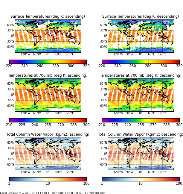
AIRS/Aqua L3 Daily Support Daily Product (AIRS+AMSU+HSB) 1 degree x 1 degree V006 (AIRH3SPD) at GES DISC recent views
National Aeronautics and Space Administration —
The Atmospheric Infrared Sounder (AIRS) is a grating spectrometer (R = 1200) aboard the second Earth Observing System (EOS) polar-orbiting platform, EOS Aqua. In... -
Federal
CERES and GEO-Enhanced TOA, Within-Atmosphere and Surface Fluxes, Clouds and Aerosols Monthly-Averaged 1-Hourly Terra-NPP Edition1A NGDA recent views
National Aeronautics and Space Administration —
CER_SYN1deg-MHour_Terra-NPP_Edition1A is the Clouds and the Earth's Radiant Energy System (CERES) and geostationary (GEO)-Enhanced Top-of-Atmosphere (TOA), Within-... -
Federal
MOPITT CO gridded daily means (Near and Thermal Infrared Radiances) V009 recent views
National Aeronautics and Space Administration —
MOP03J_9 is the Measurements Of Pollution In The Troposphere (MOPITT) Carbon Monoxide (CO) gridded daily means (Near and Thermal Infrared Radiances) version 9 data... -
Federal
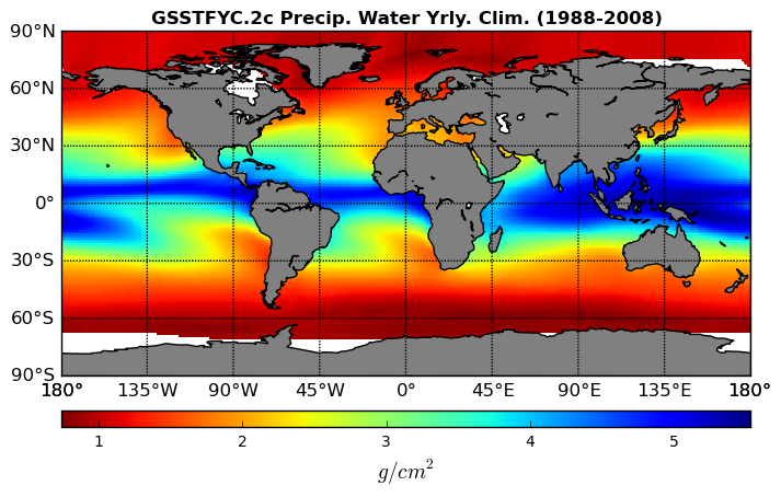
Goddard Satellite-Based Surface Turbulent Fluxes Climatology, 0.25 x 0.25 deg, Yearly Grid V3 (GSSTFYC) at GES DISC recent views
National Aeronautics and Space Administration —
These data are the Goddard Satellite-based Surface Turbulent Fluxes Version-3 Dataset recently produced through a MEaSUREs funded project led by Dr. Chung-Lin Shie... -
Federal
NAMMA LANGLEY AEROSOL RESEARCH GROUP EXPERIMENT NAVIGATION DATA V1 recent views
National Aeronautics and Space Administration —
The NAMMA Langley Aerosol Research Group Experiment Navigation Data is the DC-8 NAV data (ICATS) extracted into columns with time correction. These data files were... -
Federal
First ISCCP Regional Experiment (FIRE) Cirrus Phase II National Weather Service(NWS) Inner-Network Rawinsonde Data recent views
National Aeronautics and Space Administration —
The First ISCCP Regional Experiments have been designed to improve data products and cloud/radiation parameterizations used in general circulation models (GCMs).... -
Federal
CERES and GEO-Enhanced TOA, Within-Atmosphere and Surface Fluxes, Clouds and Aerosols 3-Hourly Terra-Aqua Edition4A NGDA recent views
National Aeronautics and Space Administration —
CER_SYN1deg-3Hour_Terra-Aqua-MODIS_Edition4A is the Clouds and the Earth's Radiant Energy System (CERES) and geostationary (GEO)-Enhanced Top of Atmosphere (TOA),... -
Federal
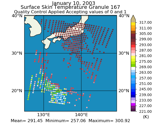
Aqua/AIRS L2 Standard Physical Retrieval (AIRS+AMSU+HSB) V7.0 at GES DISC recent views
National Aeronautics and Space Administration —
The Atmospheric Infrared Sounder (AIRS) is a grating spectrometer (R = 1200) aboard the second Earth Observing System (EOS) polar-orbiting platform, EOS Aqua. In... -
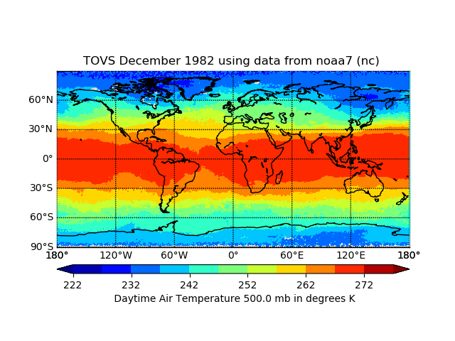
Federal
TOVS GLA MONTHLY GRIDS from NOAA-7 02 (TOVSAMNC) at GES DISC recent views
National Aeronautics and Space Administration —
This dataset (TOVSAMNC) contains the TIROS Operational Vertical Sounder (TOVS) level 3 geophysical parameters derived using data from NOAA-7 and the physical...

Official websites use .gov
A
.gov website belongs to an official government
organization in the United States.
Secure .gov websites use HTTPS
A
lock (
) or https:// means you’ve safely connected to
the .gov website. Share sensitive information only on official,
secure websites.