
-
Federal
SnowEx23 Laser Snow Microstructure Specific Surface Area Data V001
National Aeronautics and Space Administration —
Preliminary: This data set reports vertical profiles of snow reflectance and specific surface area (SSA) in Alaska, USA, in two regions, the Fairbanks region... -
State
Geologic map of the Kanayut River area, Chandler Lake Quadrangle, Alaska
State of Alaska —
Geologic map of the Kanayut River area, Chandler Lake Quadrangle, Alaska, Preliminary Interpretive Report 2009-7, presents 1:63,360-scale geologic mapping of the... -
Federal
SnowEx23 Snow Water Equivalent V001
National Aeronautics and Space Administration —
This data set presents snow depth, snow water equivalent (SWE), and bulk snow density data collected during the NASA SnowEx 2023 field campaign between March 13-16... -
Federal
NOAA/WDS Paleoclimatology - Yukon-Kuskokwim Delta, Alaska, Last millennium lake sediment macrocharcoal, biomarker, and geochemical data
National Oceanic and Atmospheric Administration, Department of Commerce —
This archived Paleoclimatology Study is available from the NOAA National Centers for Environmental Information (NCEI), under the World Data Service (WDS) for... -
Federal
NOAA/WDS Paleoclimatology - Toolik Field Station, Alaska DB - BESP - ITRDB AK190
National Oceanic and Atmospheric Administration, Department of Commerce —
This archived Paleoclimatology Study is available from the NOAA National Centers for Environmental Information (NCEI), under the World Data Service (WDS) for... -
Federal
NOAA/WDS Paleoclimatology - Higuera fire data from Uchugrak Lake, Noatak River Valley, Northwestern Alaska - IMPD USUC-001
National Oceanic and Atmospheric Administration, Department of Commerce —
This archived Paleoclimatology Study is available from the NOAA National Centers for Environmental Information (NCEI), under the World Data Service (WDS) for... -
Federal
NOAA/WDS Paleoclimatology - Chipman fire data from Upper Capsule Lake, North Slope, Alaska - IMPD USUP-001
National Oceanic and Atmospheric Administration, Department of Commerce —
This archived Paleoclimatology Study is available from the NOAA National Centers for Environmental Information (NCEI), under the World Data Service (WDS) for... -
Federal
NOAA/WDS Paleoclimatology - Shiyatov - Forest-Tundra Zone Mangazeya Swampy Site - LASI - ITRDB RUSS011
National Oceanic and Atmospheric Administration, Department of Commerce —
This archived Paleoclimatology Study is available from the NOAA National Centers for Environmental Information (NCEI), under the World Data Service (WDS) for... -
State
Field station locations and magnetic susceptibility data for the Yukon River Crossing Project, Alaska, collected June-July 2016
State of Alaska —
Field station locations and magnetic susceptibility data for the Yukon River Crossing Project, Alaska, collected June-July 2016, Raw Data File 2025-22, provides field... -
State
Reconnaissance geologic map of the Solomon D-6 Quadrangle, Seward Peninsula, Alaska
State of Alaska —
Reconnaissance geologic map of the Solomon D-6 Quadrangle, Seward Peninsula, Alaska, Open-File Report 72-325, provides 1:63,360 geologic mapping of parts of the... -
Federal
Spectral Reflectance and Ancillary Data, Tundra Transect, North Slope, AK, 2000-2022
National Aeronautics and Space Administration —
This dataset provides visible-near infrared spectral reflectance, descriptions of vegetation cover, surface temperature, the total fraction of absorbed... -
Federal
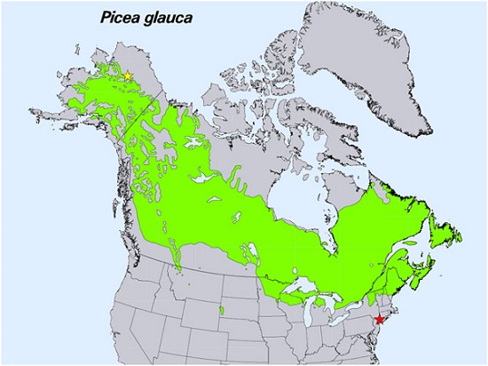
Spruce Leaf, Tree Traits, and Respiration at Range Extremes, AK and NY, USA, 2018
National Aeronautics and Space Administration —
This dataset provides in situ measurements of needle-level gas-exchange and leaf traits from Picea glauca (white spruce) from a field site located in the northern... -
Federal
RADARSAT-1 Level 1 Product
National Aeronautics and Space Administration —
RADARSAT-1 Level 1 Amplitude Images -
Federal
Tree Canopy Cover for the Circumpolar Taiga-Tundra Ecotone: 2000-2005
National Aeronautics and Space Administration —
This data set provides a map of selected areas with defined tree canopy cover over the circumpolar taiga-tundra ecotone (TTE). Canopy cover was derived from the... -
Federal
NPP Multi-Biome: Global Osnabruck Data, 1937-1981, R1
National Aeronautics and Space Administration —
This data set contains three files. The first file provides net primary productivity (NPP) estimates, vegetation characteristics, and summary climate data for 720... -
Federal
Measurement of Air Pollution from Satellites (MAPS) Space Radar Laboratory - 2 (SRL2) Carbon Monoxide 5 degree by 5 degree data
National Aeronautics and Space Administration —
MAPS OverviewThe MAPS experiment measures the global distribution of carbon monoxide (CO) mixing ratios in the free troposphere. Because of MAPS' previous flights on... -
Federal
Understory Vegetation Biomass from Selected Burned and Unburned sites in Alaska
National Aeronautics and Space Administration —
This dataset provides measurements of vegetation biomass from 11 locations across Alaska during 2016 to 2018. Vegetation was harvested from plots that were located at... -
Federal
Timeseries of Arctic-Boreal Lake Area Derived from CubeSat Imagery, 2017
National Aeronautics and Space Administration —
This dataset provides near-daily lake area timeseries for 85,358 lakes across four study areas in Northern Canada and Alaska, USA, between May 1 and October 1, 2017.... -
Federal
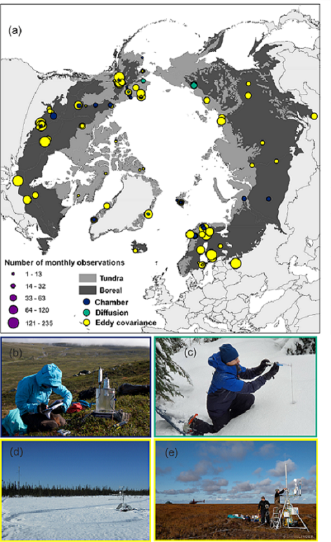
The ABCflux Database: Arctic-Boreal CO2 Flux and Site Environmental Data, 1989-2020
National Aeronautics and Space Administration —
This Arctic-Boreal CO2 fluxes (ABCflux) dataset contains monthly aggregates of terrestrial net ecosystem CO2 exchange and its derived partitioned component fluxes:...

Official websites use .gov
A
.gov website belongs to an official government
organization in the United States.
Secure .gov websites use HTTPS
A
lock (
) or https:// means you’ve safely connected to
the .gov website. Share sensitive information only on official,
secure websites.