
-
Federal
National Stormwater Calculator Unit and Regional Cost Equations and Data Variables
U.S. Environmental Protection Agency —
The spreadsheets that provide the unit and regional cost variables and equations for all of the green infrastructure and low impact development controls programmed... -
Federal
FY 1997 Blue Book: High Performance Computing and Communications: Advancing the Frontiers of Information Technology
Networking and Information Technology Research and Development, Executive Office of the President —
The Federal High Performance Computing and Communications HPCC Program will celebrate its fifth anniversary in October 1996 with an impressive array of... -
Federal
Operationalizing Software-Defined Networking: Summary of Large Scale Networking Workshop
Networking and Information Technology Research and Development, Executive Office of the President —
The Large Scale Networking Interagency Working Group held an Operationalizing Software-Defined Networks Workshop on September 18-20, 2017, in Washington, DC. At this... -
Federal
National Strategic Computing Reserve: A Blueprint
Networking and Information Technology Research and Development, Executive Office of the President —
This report outlines a Federal proposal for setting up a National Strategic Computing Reserve (NSCR) that can be called on in times of national crisis to rapidly... -
Federal
Dataset associated with Sustainable and Resilient Solid Waste Infrastructure Study conducted for Davenport, Iowa
U.S. Environmental Protection Agency —
This dataset includes outputs from MSW DST model to generate alternative waste management scenarios for Davenport IA. This dataset is associated with the following... -
Federal
FY 1998 Blue Book: Computing, Information, and Communications: Technologies for the 21st Century
Networking and Information Technology Research and Development, Executive Office of the President —
As the 21st century approaches, the rapid convergence of computing, communications, and information technology promises unprecedented opportunities for scientific... -
Federal
Federal Cybersecurity Research and Development Strategic Plan (2019)
Networking and Information Technology Research and Development, Executive Office of the President —
This 2019 Federal Cybersecurity Research and Development Strategic Plan supersedes the 2016 Federal Cybersecurity Research and Development Strategic Plan. The Plan... -
Federal
PR100: Puerto Rico Grid Resilience and Transition to 100% Renewable Energy
Department of Energy —
The Puerto Rico Grid Resilience and Transitions to 100% Renewable Energy Study (PR100) comprehensively analyzes possible pathways for Puerto Rico to achieve its... -
Federal
Feasibility Study and Assessment of Communications Approaches for Real-Time Traffic Signal Applications Study Data
Department of Transportation —
This dataset contains raw Signal Phasing and Timing (SPaT), MAP, and Basic Safety Messages (BSM) data from the "Feasibility Study and Assessment of Communications... -
Federal
Outer Coast of Washington and Oregon 2014 ESI SOCECON Lines, Points
National Oceanic and Atmospheric Administration, Department of Commerce —
This data set contains lines depicting emergency evacuation routes in the event of a tsunami, and points showing locations of airports, beaches, campgrounds, EPA... -
Federal
Wind Turbine Structure Setbacks: Ordinances (2022) and Extrapolated Trends, 115 Hub Height 170 Rotor Diameter
Department of Energy —
This dataset represents wind energy setback requirements from structures based on existing county ordinances as of April 2022. A setback requirement is a minimum... -
Federal
Vulcan: High-Resolution Annual Fossil Fuel CO2 Emissions in USA, 2010-2015, Version 3
National Aeronautics and Space Administration —
The Vulcan version 3.0 annual dataset provides estimates of annual carbon dioxide (CO2) emissions from the combustion of fossil fuels (FF) and CO2 emissions from... -
Federal
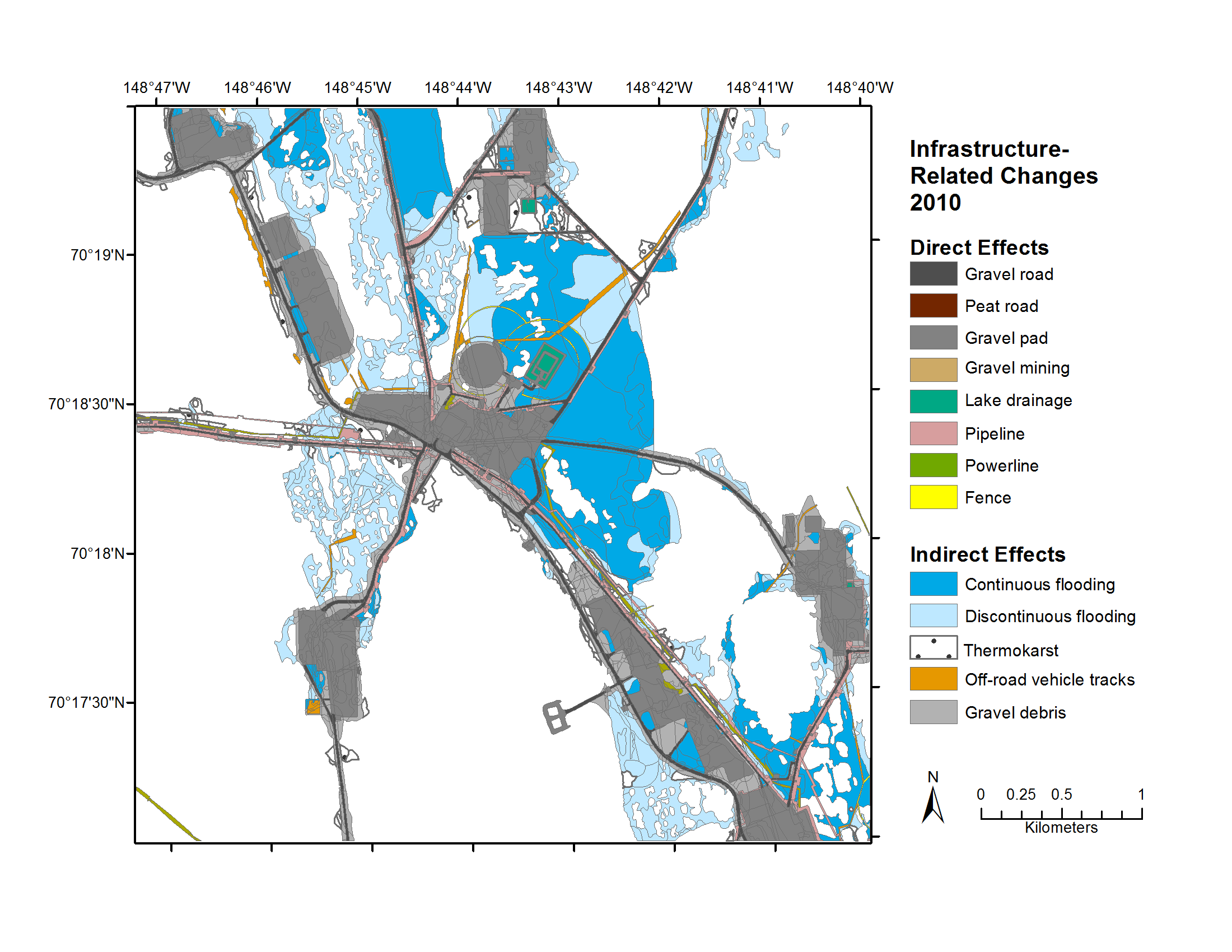
Geobotanical and Impact Map Collection for Prudhoe Bay Oilfield, Alaska, 1972-2010
National Aeronautics and Space Administration —
This data set provides a collection of maps of geoecological characteristics of areas within the Beechey Point quadrangle near Prudhoe Bay on the North slope of... -
Federal
EK60 Water Column Sonar Data Collected During AR18B
National Oceanic and Atmospheric Administration, Department of Commerce —
Cruise AR18B on RV Neil Armstrong (EK60). This is the eighth major infrastructure deployment and servicing cruise for the Pioneer Array of the National Science... -
Federal
TEAMER: Long Island Sound Tidal Resource Assessment Geodatabase Model
Department of Energy —
This submission includes the Long Island Sound (LIS) Tidal Energy Resource Geodatabase developed collaboratively by Integral Consulting Inc. and Future Island Impact... -
State
The California Energy Commission's Core Responsibilities
State of California —
This dataset contains fact sheets which cover the seven core responsibilities of the California Energy Commission. -
Federal
TS Note Vol 2 Issue 10
Department of Veterans Affairs —
VA Executive's Guide to Hybrid Data Infrastructure -
Federal
GEDI L1B Geolocated Waveform Data Global Footprint Level V002
National Aeronautics and Space Administration —
The Global Ecosystem Dynamics Investigation (GEDI) mission aims to characterize ecosystem structure and dynamics to enable radically improved quantification and...

Official websites use .gov
A
.gov website belongs to an official government
organization in the United States.
Secure .gov websites use HTTPS
A
lock (
) or https:// means you’ve safely connected to
the .gov website. Share sensitive information only on official,
secure websites.