
-
Federal
NOAA/WDS Paleoclimatology - Heyerdahl fire data from North Fork Salmon River - IMPD USNFS001
National Oceanic and Atmospheric Administration, Department of Commerce —
This archived Paleoclimatology Study is available from the NOAA National Centers for Environmental Information (NCEI), under the World Data Service (WDS) for... -
Federal
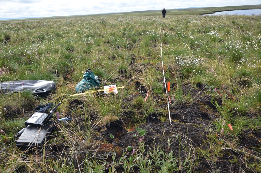
ABoVE: Soil Moisture and ALT Field Collection Protocols and Probe Calibration
National Aeronautics and Space Administration —
This dataset contains soil moisture sampling protocols and calibration algorithms for Campbell Scientific Hydrosense-I and II units used at burned and unburned sites... -
Federal
NOAA/WDS Paleoclimatology - Yao fire data from Mengkeshan, Daxing'an Mountain, Heilongjiang, China - IMPD CNMKS001
National Oceanic and Atmospheric Administration, Department of Commerce —
This archived Paleoclimatology Study is available from the NOAA National Centers for Environmental Information (NCEI), under the World Data Service (WDS) for... -
Federal
NOAA/WDS Paleoclimatology - Tepley fire data from Williams Creek, southwestern Colorado, IMPD USWCR001
National Oceanic and Atmospheric Administration, Department of Commerce —
This archived Paleoclimatology Study is available from the NOAA National Centers for Environmental Information (NCEI), under the World Data Service (WDS) for... -
Federal
NOAA/WDS Paleoclimatology - Brown fire data from Cosmic Ray Obs - IMPD USCRO001
National Oceanic and Atmospheric Administration, Department of Commerce —
This archived Paleoclimatology Study is available from the NOAA National Centers for Environmental Information (NCEI), under the World Data Service (WDS) for... -
Federal
NOAA/WDS Paleoclimatology - Hessl fire data from Havchua Tsohio Uul - IMPD MNHTU001
National Oceanic and Atmospheric Administration, Department of Commerce —
This archived Paleoclimatology Study is available from the NOAA National Centers for Environmental Information (NCEI), under the World Data Service (WDS) for... -
Federal
First ISCCP Regional Experiment (FIRE) Arctic Cloud Experiment (ACE) CFD Data
National Aeronautics and Space Administration —
The First ISCCP Regional Experiments have been designed to improve data products and cloud/radiation parameterizations used in general circulation models (GCMs).... -
Federal
Military Special Use Airspace
National Oceanic and Atmospheric Administration, Department of Commerce —
Military Special Use Airspace is airspace of defined dimensions identified by an area on the surface of the earth wherein activities must be confined because of their... -
Federal
NOAA/WDS Paleoclimatology - Swetnam fire data from Rito de los Frijoles GP. 2. - IMPD USBA2001
National Oceanic and Atmospheric Administration, Department of Commerce —
This archived Paleoclimatology Study is available from the NOAA National Centers for Environmental Information (NCEI), under the World Data Service (WDS) for... -
Federal
NOAA/WDS Paleoclimatology - Mundo fire data from Ea. Canigó W, Patagonia - IMPD ARCAN002
National Oceanic and Atmospheric Administration, Department of Commerce —
This archived Paleoclimatology Study is available from the NOAA National Centers for Environmental Information (NCEI), under the World Data Service (WDS) for... -
Federal
MODIS/Terra+Aqua Direct Broadcast Burned Area Monthly L3 Global 500m SIN Grid V006
National Aeronautics and Space Administration —
The MCD64A1 Version 6 data product was decommissioned on July 31, 2023. Users are encouraged to use the MCD64A1 Version 6.1 data product.The Terra and Aqua combined... -
Federal
NOAA/WDS Paleoclimatology - Mundo fire data from RÃo Lácteo, Patagonia - IMPD ARLAC001
National Oceanic and Atmospheric Administration, Department of Commerce —
This archived Paleoclimatology Study is available from the NOAA National Centers for Environmental Information (NCEI), under the World Data Service (WDS) for... -
Federal
SAFARI 2000 MODIS 500-m Burned Area Products, Southern Africa, Dry Season 2000
National Aeronautics and Space Administration —
The SAFARI 2000 project was selected as the first regional test for a prototype regional 500 m MODIS burned area product. The MODIS burned area product maps the 500 m... -
Federal
TROPESS CrIS-SNPP L2 Ammonia for West Coast Fires, Standard Product V1 (TRPSDL2NH3CRSWCF) at GES DISC
National Aeronautics and Space Administration —
The TROPESS CrIS-SNPP L2 Ammonia for West Coast Fires, Standard Product contains the vertical distribution of the retrieved atmospheric state of ammonia (NH3), formal... -
Federal
First ISCCP Regional Experiment (FIRE) Cirrus Phase I Langley Research Center (LARC) Eight Inch Lidar
National Aeronautics and Space Administration —
The First ISCCP Regional Experiments have been designed to improve data products and cloud/radiation parameterizations used in general circulation models (GCMs).... -
Federal
First ISCCP Regional Experiment (FIRE) Atlantic Stratocumulus Transition Experiment (ASTEX) Centre Meteorologie Spatiale (CMS) Monthly Solar Irradiance Data
National Aeronautics and Space Administration —
The First ISCCP Regional Experiments have been designed to improve data products and cloud/radiation parameterizations used in general circulation models (GCMs).... -
Federal
Arctic Vegetation Plots in Burned and Unburned Tundra, Alaska, 2011-2012
National Aeronautics and Space Administration —
This dataset provides environmental and vegetation data collected in late June and July of 2011 and of 2012 from study plots located in tundra fire scars and adjacent... -
Federal
NOAA/WDS Paleoclimatology - Brown fire data from Black Hills Plot 201 - IMPD US201001
National Oceanic and Atmospheric Administration, Department of Commerce —
This archived Paleoclimatology Study is available from the NOAA National Centers for Environmental Information (NCEI), under the World Data Service (WDS) for... -
Federal
NOAA/WDS Paleoclimatology - Bergeron fire data from Lake Duparquet Island #35 - IMPD CA035001
National Oceanic and Atmospheric Administration, Department of Commerce —
This archived Paleoclimatology Study is available from the NOAA National Centers for Environmental Information (NCEI), under the World Data Service (WDS) for...

Official websites use .gov
A
.gov website belongs to an official government
organization in the United States.
Secure .gov websites use HTTPS
A
lock (
) or https:// means you’ve safely connected to
the .gov website. Share sensitive information only on official,
secure websites.