
-
Federal
EnviroAtlas - Average Annual Soil Loss Avoided due to Vegetation (Scaled) for the Conterminous United States
U.S. Environmental Protection Agency —
This EnviroAtlas national dataset shows the average annual soil loss from each pixel avoided due to natural vegetation in metric tons per hectare*10,000 for the... -
Federal
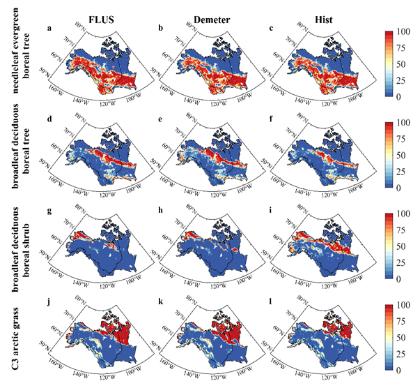
Land Use and Land Cover Change Projection in the ABoVE Domain
National Aeronautics and Space Administration —
This dataset provides projections of land use and land cover (LULC) change within the Arctic Boreal Vulnerability Experiment (ABoVE) domain, spanning from 2015 to... -
Federal
LBA-ECO ND-02 Agricultural and Secondary Forest Soil Trace Gas Flux, Para: 2001-2004
National Aeronautics and Space Administration —
Fires set for slash-and-burn agriculture contribute to the current unsustainable accumulation of atmospheric greenhouse gases, and they also deplete the soil of... -
Federal
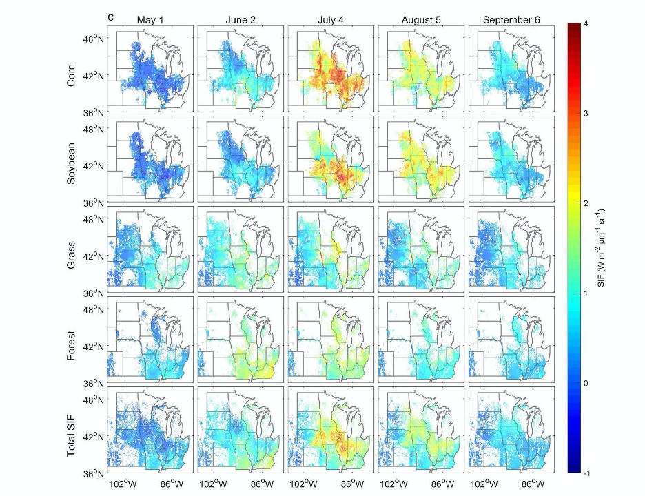
High Resolution Land Cover-Specific Solar-Induced Fluorescence, Midwestern USA, 2018
National Aeronautics and Space Administration —
This dataset provides estimated solar-induced chlorophyll fluorescence (SIF) of specific vegetation types and total SIF under clear-sky and real/cloudy conditions at... -
Federal
LBA-ECO LC-39 Modeled Carbon Flux from Deforestation, Mato Grosso, Brazil: 2000-2006
National Aeronautics and Space Administration —
This data set contains modeled estimates of carbon flux, biomass, and annual burning emissions across the Brazilian state of Mato Grosso from 2000-2006. The model,... -
Federal
LBA Regional Carbon in Live Vegetation, 0.5-degree (Olson)
National Aeronautics and Space Administration —
This data set is a subset of Olson et al. (1985, 2000) "Major World Ecosystem Complexes Ranked by Carbon in Live Vegetation." This subset was created for the study... -
Federal
Global N Cycle: Fluxes and N2O Mixing Ratios Originating from Human Activity
National Aeronautics and Space Administration —
Nitrogen is a major nutrient in terrestrial ecosystems and an important catalyst in tropospheric photochemistry. Over the last century human activities have... -
Federal
Global Food Security-support Analysis Data (GFSAD) Cropland Extent 2015 Europe, Central Asia, Russia, Middle East product 30 m V001
National Aeronautics and Space Administration —
The NASA Making Earth System Data Records for Use in Research Environments (MEaSUREs) Global Food Security-support Analysis Data (GFSAD) data product provides... -
Federal
Global Food Security-support Analysis Data (GFSAD) Cropland Extent 2015 Australia, New Zealand, China, Mongolia 30 m V001
National Aeronautics and Space Administration —
The NASA Making Earth System Data Records for Use in Research Environments (MEaSUREs) Global Food Security-support Analysis Data (GFSAD) data product provides... -
Federal
Global Food Security-support Analysis Data (GFSAD) Cropland Extent 2015 Southeast and Northeast Asia product 30 m V001
National Aeronautics and Space Administration —
The NASA Making Earth System Data Records for Use in Research Environments (MEaSUREs) Global Food Security-support Analysis Data (GFSAD) data product provides... -
Federal
Global Food Security-support Analysis Data (GFSAD) Cropland Extent 2010 North America product 30 m V001
National Aeronautics and Space Administration —
The NASA Making Earth System Data Records for Use in Research Environments (MEaSUREs) Global Food Security-support Analysis Data (GFSAD) data product provides... -
Federal
Global Food Security-support Analysis Data (GFSAD) Cropland Extent 2015 South America product 30 m V001
National Aeronautics and Space Administration —
The NASA Making Earth System Data Records for Use in Research Environments (MEaSUREs) Global Food Security-support Analysis Data (GFSAD) data product provides... -
Federal
Global Food Security-support Analysis Data (GFSAD) Cropland Extent 2015 Africa 30 m V001
National Aeronautics and Space Administration —
The NASA Making Earth System Data Records for Use in Research Environments (MEaSUREs) Global Food Security-support Analysis Data (GFSAD) data product provides... -
Federal
Global Hyperspectral Imaging Spectral-library of Agricultural crops for Central Asia V001
National Aeronautics and Space Administration —
The Global Hyperspectral Imaging Spectral-library of Agricultural crops (GHISA) is a comprehensive compilation, collation, harmonization, and standardization of... -
Federal
Global Leaf Area Index from Field Measurements, 1932-2000
National Aeronautics and Space Administration —
Approximately 1000 published estimates of leaf area index (LAI) from nearly 400 unique field sites, covering the period 1932-2000, have been compiled into a single... -
Federal
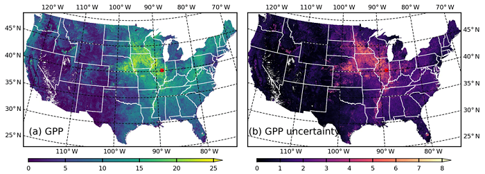
MODIS-based GPP, PAR, fC4, and SANIRv estimates from SLOPE for CONUS, 2000-2019
National Aeronautics and Space Administration —
This dataset contains estimated gross primary productivity (GPP), photosynthetically active radiation (PAR), soil adjusted near infrared reflectance of vegetation... -
Federal
FLUXNET Marconi Conference Gap-Filled Flux and Meteorology Data, 1992-2000
National Aeronautics and Space Administration —
Fluxes of carbon dioxide, water vapor, and energy exchange have been measured at 38 forest, grassland, and crop sites as part of the EUROFLUX and AmeriFlux projects.... -
Federal
Geoecology: County-Level Environmental Data for the United States, 1941-1981
National Aeronautics and Space Administration —
The Geoecology database is a compilation of environmental data for the period 1941 to 1981. The Geoecology database contains selected data on terrain and soils, water... -
Federal
CMS: Carbon Fluxes from Global Agricultural Production and Consumption, 2005-2011
National Aeronautics and Space Administration —
This data set provides global estimates of carbon fluxes associate with annual crop net primary production (NPP) and harvested biomass, annual uptake and release by...

Official websites use .gov
A
.gov website belongs to an official government
organization in the United States.
Secure .gov websites use HTTPS
A
lock (
) or https:// means you’ve safely connected to
the .gov website. Share sensitive information only on official,
secure websites.