
-
Federal
GPM GROUND VALIDATION TWO-DIMENSIONAL VIDEO DISDROMETER (2DVD) GCPEX V1
National Aeronautics and Space Administration —
The GPM Ground Validation Two-Dimensional Video Disdrometer (2DVD) GCPEX dataset was collected by the Two-Dimensional Video Disdrometer (2DVD) data, which was... -
Federal
First ISCCP Regional Experiment (FIRE) Cirrus 1 Surface Radiation Budget (SRB) Longwave Radiation Data
National Aeronautics and Space Administration —
These data contain down-welled global longwave hemispherical radiation taken during the Wisconsin FIRE/SRB experiment. The data set consists of measurements taken... -
Federal
GPM Ground Validation NEXRAD Level III KMPX IFloodS
National Aeronautics and Space Administration —
The GPM Ground Validation NEXRAD Level III KMPX IFloodS dataset contain precipitation products derived from selected NEXt Generation Weather RADar system (NEXRAD)... -
Federal
FIREX-AQ DC-8 In-Situ Trace Gas Data
National Aeronautics and Space Administration —
FIREXAQ_TraceGas_AircraftInSitu_DC8_Data are in-situ trace gas measurements conducted onboard the DC8 aircraft during FIREX-AQ. This product features data collected... -
Federal
DISCOVER-AQ Texas Deployment P-3B Aircraft In Situ Trace Gas Data
National Aeronautics and Space Administration —
DISCOVERAQ_Texas_TraceGas_AircraftInSitu_P3B_Data contains in situ trace gas data collected onboard the P-3B aircraft during the Texas (Houston) deployment of NASA's... -
Federal
CATS-ISS Level 1B Day Mode 7.2 Version 3-00
National Aeronautics and Space Administration —
CATS-ISS_L1B_D-M7.2-V3-00 is the Cloud-Aerosol Transport System (CATS) International Space Station (ISS) Level 1B Day Mode 7.2 Version 3-00 data product. This... -
Federal
GHRSST NOAA/STAR ACSPO v2.80 0.02 degree L3S Dataset from mid-Morning LEO Satellites (GDS v2)
National Aeronautics and Space Administration —
NOAA STAR produces two lines of gridded 0.02 degree super-collated L3S LEO sub-skin Sea Surface Temperature (SST) datasets, one from the NOAA afternoon JPSS... -
Federal
DISCOVER-AQ Colorado Deployment P-3B Aircraft In Situ Aerosol Data
National Aeronautics and Space Administration —
DISCOVERAQ_Colorado_Aerosol_AircraftInSitu_P3B_Data contains in situ aerosol data collected onboard NASA's P-3B aircraft during the Colorado (Denver) deployment of... -
Federal
BOREAS RSS-12 Airborne Tracking Sunphotometer Measurements (C-130)
National Aeronautics and Space Administration —
The BOREAS RSS-12 team collected both ground and airborne sunphotometer measurements for use in characterizing the aerosol optical properties of the atmosphere during... -
Federal
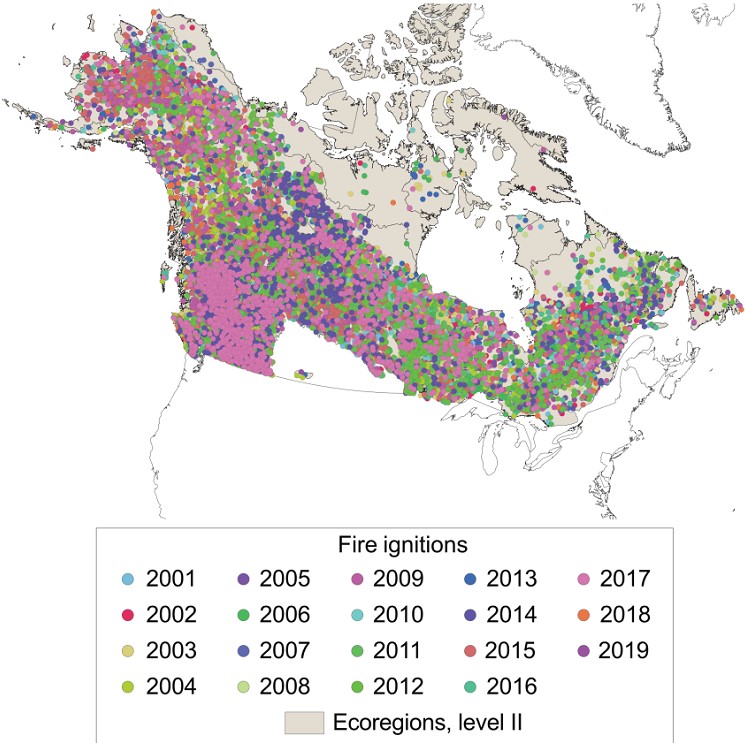
ABoVE: Ignitions of ABoVE-FED Fires in Alaska and Canada
National Aeronautics and Space Administration —
This dataset provides daily fire ignition locations and timing for boreal fires in Alaska, U.S., and Canada between 2001 and 2019. The fire ignition locations and... -
Federal
ABoVE: Last Day of Spring Snow, Alaska, USA, and Yukon Territory, Canada, 2000-2016
National Aeronautics and Space Administration —
This dataset provides the last day of spring snow cover for most of Alaska and the Yukon Territory for 2000 through 2016. The data are based on the MODIS daily snow... -
Federal
ABoVE: Soil Active Layer Thaw Depths at CRREL sites near Fairbanks, Alaska, 2014-2018
National Aeronautics and Space Administration —
This dataset provides soil active layer thaw depth measurements collected along transects at three sites near Fairbanks, Alaska, USA. Measurements were made during... -
Federal
CALIPSO Lidar Level 2 Cloud Profile, V4-21
National Aeronautics and Space Administration —
CAL_LID_L2_05kmCPro-Standard-V4-21 is the Cloud-Aerosol Lidar and Infrared Pathfinder Satellite Observations (CALIPSO) Lidar Level 2 Cloud Profile, Version 4-21 data... -
Federal
BOREAS TE-18 Biomass Density Image of the SSA
National Aeronautics and Space Administration —
This biomass density image covers almost the entire BOREAS SSA. The pixels for which biomass density is computed include areas that are in conifer land cover classes... -
Federal
BOREAS Follow-On HMet-01 Merged SSM/I and Rain Gauge Precipitation Data
National Aeronautics and Space Administration —
A gridded data set has been assembled over the BOREAS hydro-meteorological study region that combines a precipitation data set based on a rain gauge network with... -
Federal
BOREAS/SRC AMS Suite B Surface Meteorological and Radiation Data: 1994
National Aeronautics and Space Administration —
The Saskatchewan Research Council (SRC) collected surface meteorological and radiation data from December, 1993 until Decemb er 1996. The data set is comprised of the... -
Federal
IBEX High Energy Neutral Atom Imager (ENA-Hi) Data Release 10, Compton-Getting corrected, not Survival Probability corrected, Antiram direction, West Longitude Ecliptic Maps, Level H3 (H3), 7 year average Data
National Aeronautics and Space Administration —
The IBEX ENA-Hi and IBEX ENA-Lo data sets are from Release 10 of all-sky map data for the first seven years, 2009-2015, in the form of antiram direction Hydrogen, H,... -
Federal
IBEX High Energy Neutral Atom Imager (Hi) Data Release 07, not Compton-Getting corrected, not Survival Probability corrected, Omnidirectional, West Longitude Ecliptic Maps, Level H3 (H3), semiannually averaged Data
National Aeronautics and Space Administration —
1: The Interstellar Boundary Explorer (IBEX) has operated in space since 2008 updating our knowledge of the outer heliosphere and its interaction with the local... -
Federal
IBEX High Energy Neutral Atom Imager (Hi) Data Release 07, not Compton-Getting corrected, Survival Probability corrected, Ram direction, West Longitude Ecliptic Maps, Level H3 (H3), annually averaged Data
National Aeronautics and Space Administration —
1: The Interstellar Boundary Explorer (IBEX) has operated in space since 2008 updating our knowledge of the outer heliosphere and its interaction with the local... -
Federal
IBEX High Energy Neutral Atom Imager (ENA-Hi) Data Release 10, Compton-Getting corrected, not Survival Probability corrected, Antiram direction, West Longitude Ecliptic Maps, 1 year averaged data, Level H3
National Aeronautics and Space Administration —
This IBEX-Hi data set is from Release 10 of all-sky map data for the first seven years, 2009-2015, in the form of antiram direction Hydrogen, H, energetic neutral...

Official websites use .gov
A
.gov website belongs to an official government
organization in the United States.
Secure .gov websites use HTTPS
A
lock (
) or https:// means you’ve safely connected to
the .gov website. Share sensitive information only on official,
secure websites.