

11,735 datasets found for "注册送彩金✅澳门葡京赌场官方网站-网址【079.one】㊙️最火爆PG电子超高爆奖率,注册即送38元.SWdRGRveHMNXuo"
-
Federal
VIIRS/NPP BRDF/Albedo Parameter 1 Band M11 Daily L3 Global 30 ArcSec CMG V001
National Aeronautics and Space Administration —
The VNP43D25 Version 1 data product was decommissioned on July 31, 2025. Users are encouraged to use the VNP43D25 and VJ143D25 Version 2 data products.The NASA/NOAA... -
Federal
VIIRS/NPP BRDF/Albedo Parameter 1 Band M5 Daily L3 Global 30 ArcSec CMG V002
National Aeronautics and Space Administration —
The NASA/NOAA Suomi National Polar-orbiting Partnership (Suomi NPP) Visible Infrared Imaging Radiometer Suite (VIIRS) Bidirectional Reflectance Distribution Function... -
Federal
VIIRS/NPP BRDF/Albedo Parameter 1 VIS Daily L3 Global 30 ArcSec CMG V002
National Aeronautics and Space Administration —
The NASA/NOAA Suomi National Polar-orbiting Partnership (Suomi NPP) Visible Infrared Imaging Radiometer Suite (VIIRS) Bidirectional Reflectance Distribution Function... -
Federal
VIIRS/NPP BRDF/Albedo BSA at Solar Noon Band M4 Daily L3 Global 30ArcSec CMG V001
National Aeronautics and Space Administration —
The VNP43D57 Version 1 data product was decommissioned on July 31, 2025. Users are encouraged to use the VNP43D57 and VJ143D57 Version 2 data products.The NASA/NOAA... -
Federal
VIIRS/JPSS2 Day/Night Band 6-Min L1B Swath SDR 750m NRT
National Aeronautics and Space Administration —
The Near Real Time (NRT) VIIRS Level 1 and Level 2 swath (VJ202DNB_NRT) product is single NASA VIIRS panchromatic Day-Night band (DNB) calibrated radiance product.... -
Federal
TES/Aura L2 Instantaneous Radiative Kernel Nadir V008
National Aeronautics and Space Administration —
TL2IRKN_8 is the Tropospheric Emission Spectrometer (TES)/Aura Level 2 Atmospheric Temperatures Limb Version 8 data product. TES was an instrument aboard NASA's Aura... -
Federal
TES/Aura L3 HNO3 Daily Gridded V004
National Aeronautics and Space Administration —
TL3HNOD_4 is the Tropospheric Emission Spectrometer (TES)/Aura Level 2 Atmospheric Temperatures Limb Version 4 data product. TES was an instrument aboard NASA's Aura... -
Federal
TES/Aura L2 Deuterium Oxide Nadir Special Observation V008
National Aeronautics and Space Administration —
TL2HDONS_8 is the Tropospheric Emission Spectrometer (TES)/Aura Level 2 Deuterium Oxide Nadir Special Observation Version 8 data product. TES was an instrument aboard... -
Federal
TES/Aura L2 Ammonia Nadir V008
National Aeronautics and Space Administration —
TL2NH3N_8 is the Tropospheric Emission Spectrometer (TES)/Aura Level 2 Ammonia Nadir Version 8 data product. TES was an instrument aboard NASA's Aura satellite and... -
Federal
SWOT 2019-2020 Prelaunch Oceanography Field Campaign SIO Mooring WireWalker (WW)
National Aeronautics and Space Administration —
This dataset provides the conductivity, temperature and depth (CTD) measurements from the CTD sensors on a WireWalker profiler on a full-depth mooring deployed by the... -
Federal
Sounder SIPS: JPSS-1 CrIS Level 3 Specific Quality Control Gridded Daily CLIMCAPS V2 (SNDRJ1IML3SDCCP) at GES DISC
National Aeronautics and Space Administration —
WARNING: To users of the derived product “co_mmr_midtrop” (carbon monoxide mass mixing ratio to dry air [kg/kg] at ~500 hPa). This variable has a significant bias due... -
Federal
SAFARI 2000 Potential Vegetation, 5-min (Ramankutty and Foley)
National Aeronautics and Space Administration —
The data set consists of a southern Africa subset of the 5-min resolution Global Potential Vegetation data set developed by Navin Ramankutty and Jon Foley at the... -
Federal
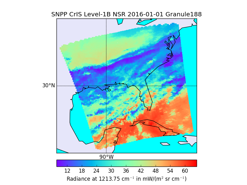
S-NPP CrIS IMG_COL: Array indices for collocated VIIRS observations V2 (SNDRSNCrISL1BIMGC) at GES DISC
National Aeronautics and Space Administration —
The Cross-track Infrared Sounder (CrIS) Level 1B Normal Spectral Resolution (NSR) data files contain radiance measurements along with ancillary spacecraft,... -
Federal
NPP Multi-Biome: Global Osnabruck Data, 1937-1981, R1
National Aeronautics and Space Administration —
This data set contains three files. The first file provides net primary productivity (NPP) estimates, vegetation characteristics, and summary climate data for 720... -
Federal
NASA Water Vapor Project MEaSUREs (NVAP-M) CLIMATE Layered Precipitable Water
National Aeronautics and Space Administration —
NVAP_CLIMATE_Layered-Precipitable-Water data set is designed to provide the most stable water vapor data set over time for use in climate applications. NASA Water...
11,735 datasets found for "注册送彩金✅澳门葡京赌场官方网站-网址【079.one】㊙️最火爆PG电子超高爆奖率,注册即送38元.SWdRGRveHMNXuo"