
-
Federal
H12062: NOS Hydrographic Survey , Florida and Alabama Safety Fairways, Florida, 2010-05-11 recent views
National Oceanic and Atmospheric Administration, Department of Commerce —
The National Oceanic and Atmospheric Administration (NOAA) has the statutory mandate to collect hydrographic data in support of nautical chart compilation for safe... -
Federal
RapidScat Level 2A Surface Flagged Sigma-0 and Attenuations in 25km Swath Grid Version 2.0 recent views
National Aeronautics and Space Administration —
This dataset contains the Version 2.0 ISS-RapidScat Level 2A 25km science data record, which provides surface-flagged sigma-0 in 25km Wind Vector Cells processed... -
Federal
MODIS-derived Aggregate, Woody and Herbaceous Leaf Area Index for Africa, 2002-2022 NGDA recent views
National Aeronautics and Space Administration —
This dataset provides leaf area index (LAI) estimates for Sub-Saharan Africa for woody, herbaceous, and aggregate vegetation types. The estimates were derived from... -
Federal
H13273: NOS Hydrographic Survey , 2019-09-20 recent views
National Oceanic and Atmospheric Administration, Department of Commerce —
The National Oceanic and Atmospheric Administration (NOAA) has the statutory mandate to collect hydrographic data in support of nautical chart compilation for safe... -
Federal
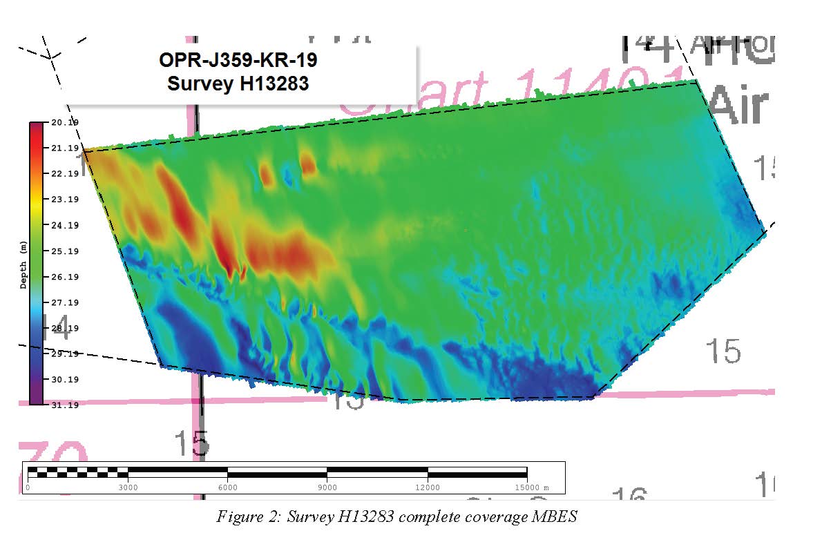
H13283: NOS Hydrographic Survey , 2019-11-26 recent views
National Oceanic and Atmospheric Administration, Department of Commerce —
The National Oceanic and Atmospheric Administration (NOAA) has the statutory mandate to collect hydrographic data in support of nautical chart compilation for safe... -
Federal
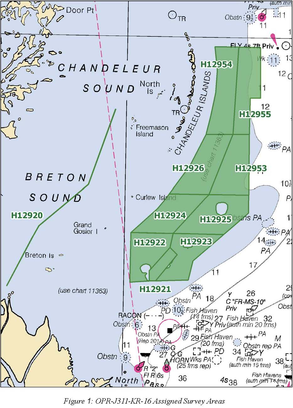
H12954: NOS Hydrographic Survey , 2016-11-16 recent views
National Oceanic and Atmospheric Administration, Department of Commerce —
The National Oceanic and Atmospheric Administration (NOAA) has the statutory mandate to collect hydrographic data in support of nautical chart compilation for safe... -
Federal
CYGNSS Level 3 MRG Science Data Record Version 3.2 recent views
National Aeronautics and Space Administration —
This dataset contains the Version 3.2 CYGNSS Level 3 Science Data Record which provides the average wind speed and mean square slope (MSS) on a 0.2x0.2 degree... -
Federal
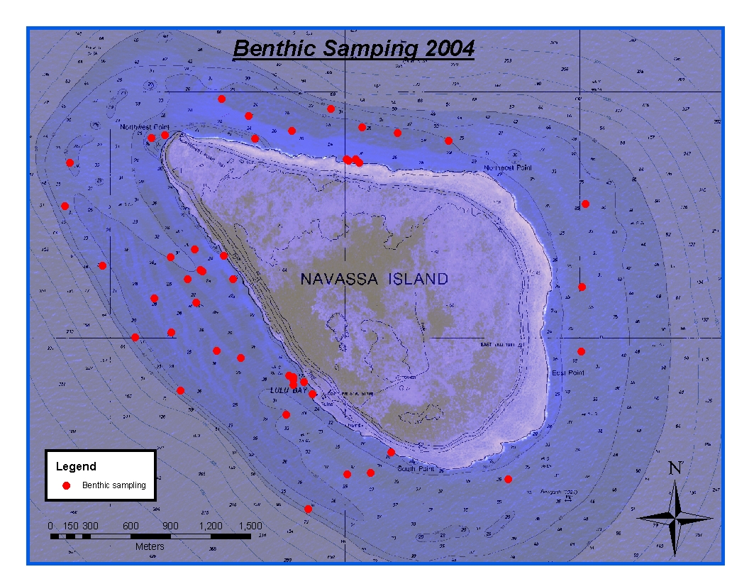
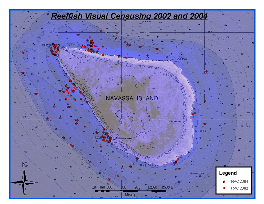
CRCP-Navassa reef assessment recent views
National Oceanic and Atmospheric Administration, Department of Commerce —
Episodic cruises ( every 2 years) were conducted to perform assessments of Navassa Island coral reef resources including reeffish visual census, benthic reef... -
Federal
H13252: NOS Hydrographic Survey , 2019-09-03 recent views
National Oceanic and Atmospheric Administration, Department of Commerce —
The National Oceanic and Atmospheric Administration (NOAA) has the statutory mandate to collect hydrographic data in support of nautical chart compilation for safe... -
Federal
H13399: NOS Hydrographic Survey , 2021-07-07 recent views
National Oceanic and Atmospheric Administration, Department of Commerce —
The National Oceanic and Atmospheric Administration (NOAA) has the statutory mandate to collect hydrographic data in support of nautical chart compilation for safe... -
Federal
H13251: NOS Hydrographic Survey , 2019-08-13 recent views
National Oceanic and Atmospheric Administration, Department of Commerce —
The National Oceanic and Atmospheric Administration (NOAA) has the statutory mandate to collect hydrographic data in support of nautical chart compilation for safe... -
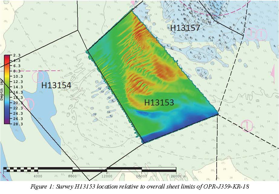
Federal
H13153: NOS Hydrographic Survey , 2018-09-28 recent views
National Oceanic and Atmospheric Administration, Department of Commerce —
The National Oceanic and Atmospheric Administration (NOAA) has the statutory mandate to collect hydrographic data in support of nautical chart compilation for safe... -
Federal
Aquarius Official Release Level 3 Rain-flagged Sea Surface Salinity Standard Mapped Image Descending 28-Day Running Mean Data V5.0 recent views
National Aeronautics and Space Administration —
Aquarius Level 3 sea surface salinity (SSS) rain-flagged standard mapped image data contains gridded 1 degree spatial resolution SSS averaged over daily, 7 day,... -
Federal
ECCO Ocean and Sea-Ice Surface Freshwater Fluxes - Daily Mean llc90 Grid (Version 4 Release 4) recent views
National Aeronautics and Space Administration —
This dataset provides daily-averaged ocean and sea-ice surface freshwater fluxes on the native Lat-Lon-Cap 90 (LLC90) model grid from the ECCO Version 4 Release 4... -
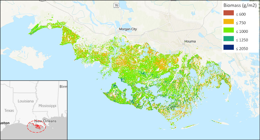
Federal
Aboveground Biomass High-Resolution Maps for Selected US Tidal Marshes, 2015 recent views
National Aeronautics and Space Administration —
This dataset provides maps of aboveground tidal marsh biomass (g/m2) at 30 m resolution for six estuarine regions of the conterminous United States: Cape Cod, MA;... -
Federal
Global Multihazard Frequency and Distribution recent views
National Aeronautics and Space Administration —
The Global Multihazard Frequency and Distribution is a 2.5 minute grid presenting a simple multihazard index based solely on summated single-hazard decile values. The... -
Federal
SWOT Level 2 Nadir Altimeter Geophysical Data Record with Waveforms recent views
National Aeronautics and Space Administration —
The SWOT Level 2 Nadir Altimeter Geophysical Data Record (GDR) with Waveforms dataset produced by the Surface Water and Ocean Topography (SWOT) mission provides sea... -
Federal
H13403: NOS Hydrographic Survey , 2021-07-16 recent views
National Oceanic and Atmospheric Administration, Department of Commerce —
The National Oceanic and Atmospheric Administration (NOAA) has the statutory mandate to collect hydrographic data in support of nautical chart compilation for safe... -
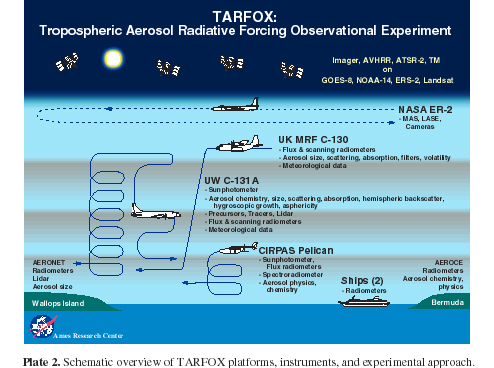
Federal
CAR TARFOX Tropospheric Aerosol Experiment BRDF V2 (CAR_TARFOX_BRDF) at GES DISC recent views
National Aeronautics and Space Administration —
CAR TARFOX mission collected data in the western Atlantic Ocean on the effects of tropospheric aerosols on radiation budgets in cloud free skies. The mission also... -
Federal
GHRSST Level 3U NOAA STAR SST v2.80 from VIIRS on NOAA-20 Satellite recent views
National Aeronautics and Space Administration —
NOAA-20 (N20/JPSS-1/J1) is the second satellite in the US NOAA latest generation Joint Polar Satellite System (JPSS), launched on November 18, 2017. The ACSPO...

Official websites use .gov
A
.gov website belongs to an official government
organization in the United States.
Secure .gov websites use HTTPS
A
lock (
) or https:// means you’ve safely connected to
the .gov website. Share sensitive information only on official,
secure websites.