
-
Federal
ABoVE: Reflectance Spectra of Tundra Plant Communities across Northern Alaska
National Aeronautics and Space Administration —
This dataset reports full-spectrum (350-2500 nm) reflectance measurements of diverse plant communities at the plot-level and individual plant species at the leaf-... -
Federal
BOREAS HYD-05 Bear Trap Creek and Namekus Lake Winter Surface Flux Data
National Aeronautics and Space Administration —
The BOREAS HYD-05 team collected tower flux, surface meteorological, and surface temperature data on a frozen lake (Namekus Lake) and in a mature jack pine forest in... -
Federal
Ground-Based Vegetation Community Photos, Toolik Lake Area, Alaska, 2014-2015
National Aeronautics and Space Administration —
This dataset contains 731 ground-based nadir vegetation community and ground surface photographs of selected field plots taken as ground reference data for vegetation... -
Federal
Arctic Vegetation Plots at Imnavait Creek, Alaska, 1984-1985
National Aeronautics and Space Administration —
This dataset provides environmental, soil, and vegetation data collected during the periods of August 1984 and August-September 1985 from 84 study plots at the... -
Federal
Shoreline Data Rescue Project of Wappoo Creek and Edisto Island, South Carolina, EC15C03 NGDA
National Oceanic and Atmospheric Administration, Department of Commerce —
These data were automated to provide an accurate high-resolution historical shoreline of Wappoo Creek and Edisto Island, South Carolina suitable as a geographic... -
Federal
Shoreline Data Rescue Project of Matinecock Point to Rosalyn Creek, Vicinity of Shoreham Beach, NY, NY1886A NGDA
National Oceanic and Atmospheric Administration, Department of Commerce —
These data were automated to provide an accurate high-resolution historical shoreline of Matinecock Point to Rosalyn Creek, Vicinity of Shoreham Beach, NY suitable as... -
Federal
Shoreline Data Rescue Project of Evertts Creek to Jacksonville, NC, NC1933A NGDA
National Oceanic and Atmospheric Administration, Department of Commerce —
These data were automated to provide an accurate high-resolution historical shoreline of Evertts Creek to Jacksonville, NC suitable as a geographic information system... -
Federal
Shoreline Data Rescue Project of Coast of CA, North of Point San Pedro to Tunitas Creek, CA, CA37B04 NGDA
National Oceanic and Atmospheric Administration, Department of Commerce —
These data were automated to provide an accurate high-resolution historical shoreline of Coast of CA, North of Point San Pedro to Tunitas Creek, CA suitable as a... -
Federal
Shoreline Data Rescue Project of Skull Creek and Vicintiy, SC, SC1931A NGDA
National Oceanic and Atmospheric Administration, Department of Commerce —
These data were automated to provide an accurate high-resolution historical shoreline of Skull Creek and Vicintiy, SC suitable as a geographic information system... -
Federal
Shoreline Data Rescue Project of Goose Creek - Pamlico River to Oriental Neuse River, NC, PH20A NGDA
National Oceanic and Atmospheric Administration, Department of Commerce —
These data were automated to provide an accurate high-resolution historical shoreline of Goose Creek - Pamlico River to Oriental Neuse River, NC suitable as a... -
Federal
H10790: NOS Hydrographic Survey , Northern Chesapeake Bay - Baltimore Harbor, Maryland, 1998-06-30
National Oceanic and Atmospheric Administration, Department of Commerce —
The National Oceanic and Atmospheric Administration (NOAA) has the statutory mandate to collect hydrographic data in support of nautical chart compilation for safe... -
Federal
H11221: NOS Hydrographic Survey , Brunswick, Georgia to Jacksonville, Florida, 2004-11-30
National Oceanic and Atmospheric Administration, Department of Commerce —
The National Oceanic and Atmospheric Administration (NOAA) has the statutory mandate to collect hydrographic data in support of nautical chart compilation for safe... -
Federal
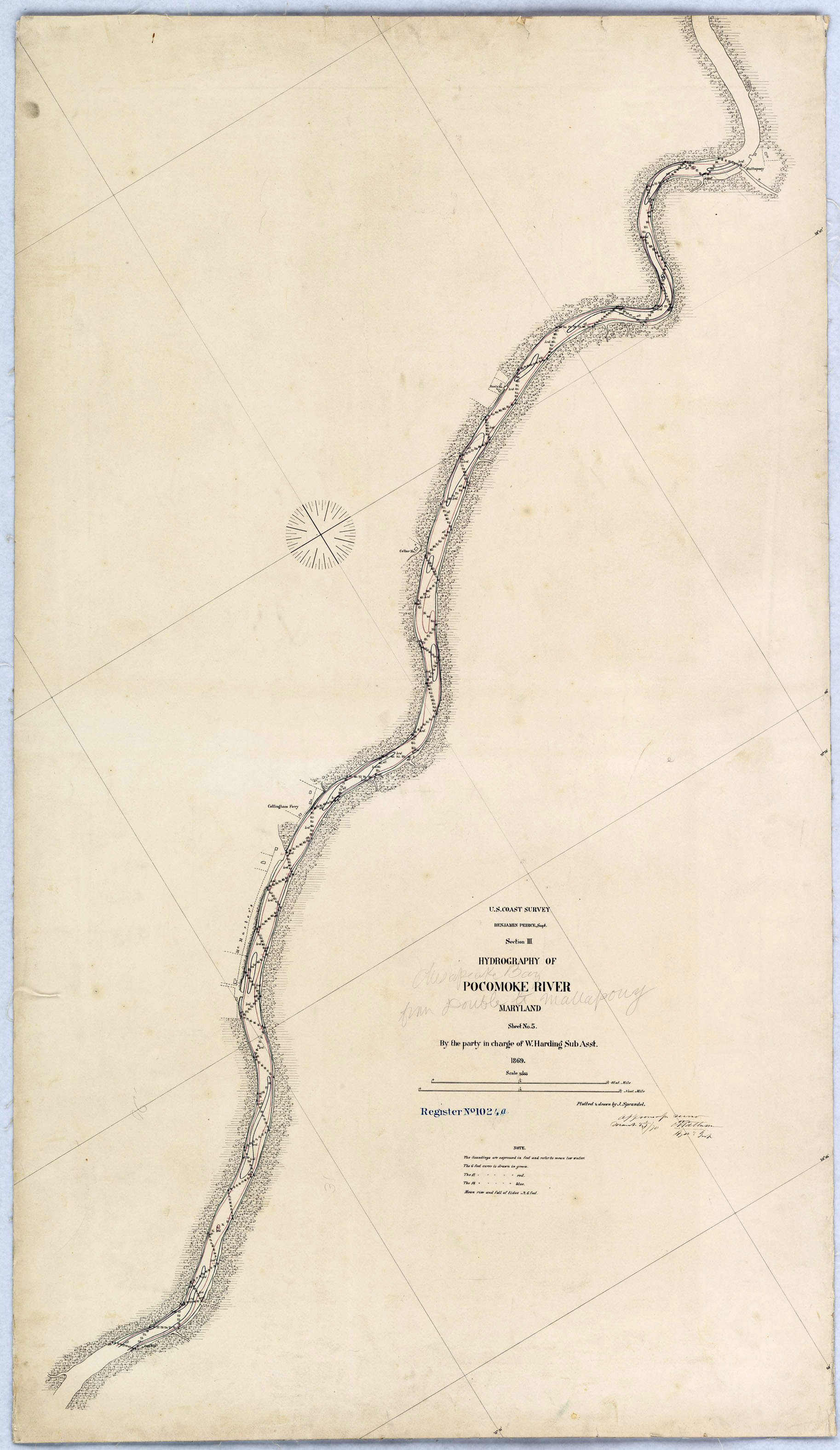
H01024C: NOS Hydrographic Survey
National Oceanic and Atmospheric Administration, Department of Commerce —
The National Oceanic and Atmospheric Administration (NOAA) has the statutory mandate to collect hydrographic data in support of nautical chart compilation for safe... -
Federal
H00967: NOS Hydrographic Survey
National Oceanic and Atmospheric Administration, Department of Commerce —
The National Oceanic and Atmospheric Administration (NOAA) has the statutory mandate to collect hydrographic data in support of nautical chart compilation for safe... -
Federal
H00637: NOS Hydrographic Survey
National Oceanic and Atmospheric Administration, Department of Commerce —
The National Oceanic and Atmospheric Administration (NOAA) has the statutory mandate to collect hydrographic data in support of nautical chart compilation for safe... -
Federal
H00804: NOS Hydrographic Survey
National Oceanic and Atmospheric Administration, Department of Commerce —
The National Oceanic and Atmospheric Administration (NOAA) has the statutory mandate to collect hydrographic data in support of nautical chart compilation for safe... -
Federal
H10218: NOS Hydrographic Survey , St. Marys River, Michigan, 1986-09-12
National Oceanic and Atmospheric Administration, Department of Commerce —
The National Oceanic and Atmospheric Administration (NOAA) has the statutory mandate to collect hydrographic data in support of nautical chart compilation for safe... -
Federal
TOMAHAWK CREEK NEAR TOMAHAWK
National Oceanic and Atmospheric Administration, Department of Commerce —
Timeseries data from 'TOMAHAWK CREEK NEAR TOMAHAWK' (ca_hydro_05DE009) -
Federal
HOLMES CREEK AT VERNON, FLA. (USGS 02366000)
National Oceanic and Atmospheric Administration, Department of Commerce —
Timeseries data from 'HOLMES CREEK AT VERNON, FLA. (USGS 02366000)' (gov_usgs_nwis_02366000) -
Federal
BOSWORTH CREEK NEAR NORMAN WELLS
National Oceanic and Atmospheric Administration, Department of Commerce —
Timeseries data from 'BOSWORTH CREEK NEAR NORMAN WELLS' (ca_hydro_10KA007)

Official websites use .gov
A
.gov website belongs to an official government
organization in the United States.
Secure .gov websites use HTTPS
A
lock (
) or https:// means you’ve safely connected to
the .gov website. Share sensitive information only on official,
secure websites.
.jpg)