

1,119 datasets found for "State Forests"
-
Federal
Forest Carnivore Inventory for Olympic National Park tabular data
Department of the Interior —
Forest carnivore inventory tabular data for Olympic National Park, 2001-2003. These data represent results from the use of remotely triggered camera traps to... -
Federal
Vascular Plant Inventory for Ebey’s Landing National Historical Reserve tabular data
Department of the Interior —
A vascular plant inventory was conducted within Ebey’s Landing National Historical Reserve (EBLA) between 2002 and 2005. Inventory methods included data mining and... -
Federal
Prince William Forest Park Forest Gaps
Department of the Interior —
LiDAR derived vector representation of forested and forest gap areas of PRWI. These data are part of a large data set describing the three-dimensional structure of... -
Federal
Imagery data for the Vegetation Mapping Inventory Project of Marsh-Billings-Rockefeller National Historical Park
Department of the Interior —
This reference contains the imagery data used in the completion of the baseline vegetation inventory project for the NPS park unit. Orthophotos, raw imagery, and... -
Federal
NCCN Landscape Dynamics Monitoring MORA geospatial data 1985-2009
Department of the Interior —
NOTE: this version, V2B, has been REPLACED by reference 2294375: https://irma.nps.gov/DataStore/Reference/Profile/2294375. The 2294375 replacement was derived using... -
Federal
Big Island National Wildlife Refuge Complex, Hakalau Forest and Kona Units: Invasive Plant Inventory and Early Detection Prioritization Tool (IPIEDT) - Area, Species, Area-Species Link Tables, 2020
Department of the Interior —
The IPIEDT is an Access Database file. The user responds to questions in a “yes/no/unknown” format or chooses from a list of states or conditions that best describe... -
Federal
Modeling Spatial Variation in Density of Golden Eagle Nest Sites in the Western United States: Spatial Data and Maps
Department of the Interior —
Golden eagle (Aquila chrysaetos) nest site model spatial data and maps as described in Dunk JR, Woodbridge B, Lickfett TM, Bedrosian G, Noon BR, LaPlante DW, et al.... -
Federal
Rivers (resistance surface component) - A landscape connectivity analysis for the coastal marten (Martes caurina humboldtensis)
Department of the Interior —
The resistance surface that formed the basis of our coastal marten connectivity model is comprised of several data layers that represent forested and non-forested... -
Federal
Waterbodies (resistance surface component) - A landscape connectivity analysis for the coastal marten (Martes caurina humboldtensis)
Department of the Interior —
The resistance surface that formed the basis of our coastal marten connectivity model is comprised of several data layers that represent forested and non-forested... -
Federal
Forested land cover (resistance surface component) - A landscape connectivity analysis for the coastal marten (Martes caurina humboldtensis)
Department of the Interior —
The resistance surface that formed the basis of our coastal marten connectivity model is comprised of several data layers that represent forested and non-forested... -
Federal
Habitat surface - A landscape connectivity analysis for the coastal marten (Martes caurina humboldtensis)
Department of the Interior —
This dataset serves as the habitat surface that was used to derive coastal marten habitat cores for use in our connectivity model. Of note, the set of habitat cores... -
Federal
Digital Glacial Geologic-GIS Map Showing Limits of Tahoe Glaciation in Sequoia and Kings Canyon National Parks, California (NPS, GRD, GRI, SEKI, TAGL_glacial digital map) adapted from a U.S. Geological Survey Scientific Investigations Map by Moore and Mack (2008)
Department of the Interior —
The Digital Glacial Geologic-GIS Map Showing Limits of Tahoe Glaciation in Sequoia and Kings Canyon National Parks, California is composed of GIS data layers and GIS... -
Federal
NCCN Landscape Dynamics Monitoring NOCA geospatial data 1985-2009
Department of the Interior —
NOTE: this version, V2B, has been REPLACED by reference 2294375: https://irma.nps.gov/DataStore/Reference/Profile/2294375. The 2294375 replacement was derived using... -
Federal
NCCN Landscape Dynamics Monitoring OLYM geospatial data 1985-2010
Department of the Interior —
NOTE: this version, V2B, has been REPLACED by reference 2294375: https://irma.nps.gov/DataStore/Reference/Profile/2294375. The 2294375 replacement was derived using... -
Federal
Vegetation Classification of Plant Communities at Choctaw National Wildlife Refuge based on UNESCO system
Department of the Interior —
The natural communities in Choctaw National Wildlife Refuge are being classified in accordance with the system developed by The Nature Conservancy (TNC) in... -
Federal
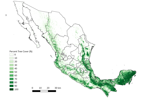
Tree Cover Estimates at 30 m Resolution for Mexico, 2016-2018
National Aeronautics and Space Administration —
The data set provides multi-year (2016-2018) percent tree cover (TC) estimates for entire Mexico at 30 m spatial resolution. The TC data (hereafter, NEX-TC) was... -
Federal
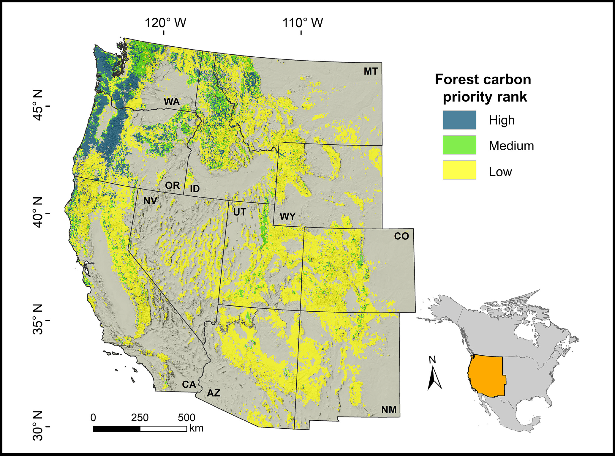
Forest Preservation Ranking and Vertebrate Species Richness, Western USA, 2020-2099
National Aeronautics and Space Administration —
This dataset provides related gridded outputs of future modeled forest carbon sequestration priority and related species richness and habitat suitability for the... -
Federal
LBA-ECO ND-07 Hydrochemistry of Natural and Developed Land Cover, Brasilia, Brazil
National Aeronautics and Space Administration —
This data set reports on dissolved nutrient concentrations, as well as dissolved oxygen, alkalinity, conductivity, turbidity, and pH measured in water samples... -
Federal
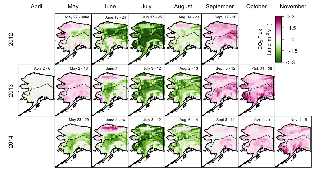
CARVE: Net Ecosystem CO2 Exchange and Regional Carbon Budgets for Alaska, 2012-2014
National Aeronautics and Space Administration —
This data set provides estimates of 3-hourly net ecosystem CO2 exchange (NEE) at 0.5-degree resolution over the state of Alaska for 2012-2014. The NEE estimates are...
1,119 datasets found for "State Forests"