

1,085 datasets found for "trees"
-
Federal
Sequoyah National Wildlife Refuge land cover and waterfowl habitat classification using SPOT-5 imagery
Department of the Interior —
developing effective habitat conservation and management strategies. The relationship between available habitat and waterfowl numbers obtained from aerial survey... -
Federal
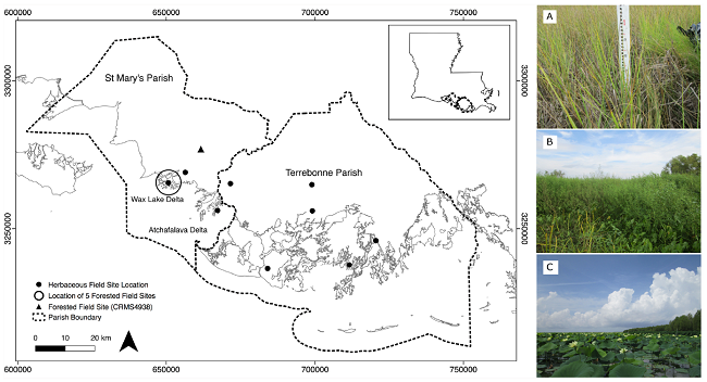
Pre-Delta-X: Vegetation Species, Structure, Aboveground Biomass, MRD, LA, USA, 2015
National Aeronautics and Space Administration —
This dataset provides vegetation species, height, stem density and diameter, and species aboveground biomass (AGB) measurements collected at herbaceous and forested... -
Federal
SAFARI 2000 Vegetation Structure of Kataba Forest, Zambia, Wet Season 2000
National Aeronautics and Space Administration —
Tree basal area, percent tree canopy cover, and proportional contribution of main species to canopy cover were measured at 60 sampling points at 50 m intervals along... -
Federal
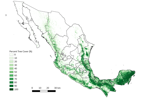
Tree Cover Estimates at 30 m Resolution for Mexico, 2016-2018
National Aeronautics and Space Administration —
The data set provides multi-year (2016-2018) percent tree cover (TC) estimates for entire Mexico at 30 m spatial resolution. The TC data (hereafter, NEX-TC) was... -
Federal
Fire Intensity and Burn Severity Metrics for Circumpolar Boreal Forests, 2001-2013
National Aeronautics and Space Administration —
This data set provides products characterizing immediate and longer-term ecosystem changes from fires in the circumpolar boreal forests of Northern Eurasia and North...
1,085 datasets found for "trees"