
-
Federal
Voyager 1 9.6-s Averaged Triaxial Fluxgate Magnetometer (MAG) Interplanetary Magnetic Field in CDF Format
National Aeronautics and Space Administration —
This data set includes the Voyager spacecraft number (1 or 2), the date-time in decimal year (90.00000 is day 1 of 1990), the magnetic field strength, F1, computed... -
Federal
Barnes Ice Cap South Dome Trilateration Net Survey Data 1970-1984, Version 1
National Aeronautics and Space Administration —
The Barnes Ice Cap data set contains survey measurements of a network of 43 stakes along a 10 km flow line on the northeast flank of the south dome of the Barnes Ice... -
Federal
MMS 3 Hot Plasma Composition Analyzer (HPCA) Time of Flight, TOF, Counts, Level 2 (L2), Survey Mode, 0.625 s Data
National Aeronautics and Space Administration —
Hot Plasma Composition Analyzer (HPCA) Time of Flight, TOF, Counts, Level 2, Survey 10 s Data. The MMS HPCA instruments measure the energy and composition of... -
Federal
Delta-X: Land Subsidence Rate, Mississippi River Delta (MRD), Louisiana, USA
National Aeronautics and Space Administration —
This dataset provides estimates of land subsidence rates for the Delta-X domain area within the Atchafalaya and Terrebonne basins for 2021. The study area is a... -
Federal
Delta-X: Real-Time Kinematic Elevation Measurements for Coastal Wetlands, LA, 2021
National Aeronautics and Space Administration —
This dataset provides real-time kinematic (RTK) GPS elevation measurements, along with horizontal and vertical precision errors, obtained along transects near... -
Federal
CAMEX-4 DC-8 MICROWAVE TEMPERATURE PROFILER (MTP) V1
National Aeronautics and Space Administration —
The CAMEX-4 DC-8 Microwave Temperature Profiler (MTP) dataset was collected by the MTP, which is a passive microwave radiometer used during the CAMEX-4 campaign to... -
Federal
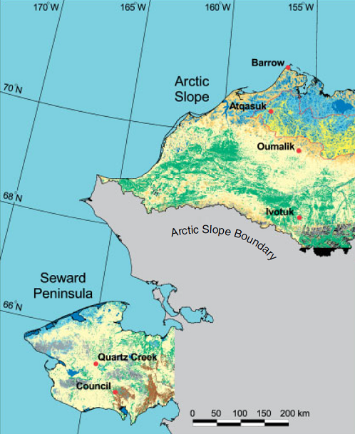
Arctic Vegetation Plots ATLAS Project North Slope and Seward Peninsula, AK, 1998-2000
National Aeronautics and Space Administration —
This data set provides environmental, soil, and vegetation data collected from study sites on the North Slope and Seward Peninsula of Alaska during the Arctic... -
Federal
Arctic Alaska Vegetation, Geobotanical, Physiographic Maps, 1993-2005
National Aeronautics and Space Administration —
This data set provides the spatial distributions of vegetation types, geobotanical characteristics, and physiographic features for the Arctic tundra region of Alaska... -
Federal
BOREAS Regional DEM in Raster Format and AEAC Projection
National Aeronautics and Space Administration —
This data set is based on the GTOPO30 DEM produced by the USGS EDC. The BOREAS region (1,000km x 1000km) was extracted from the GTOPO30 data and reprojected by BOREAS... -
Federal
ASTER Global Emissivity Dataset, 1 kilometer, HDF5 V003
National Aeronautics and Space Administration —
The Terra Advanced Spaceborne Thermal Emission and Reflection Radiometer (ASTER) Global Emissivity Dataset (GED) land surface temperature and emissivity (LST&E)... -
Federal
Arctic Vegetation Plots on Unalaska Island, Aleutian Islands, Alaska, 2007
National Aeronautics and Space Administration —
This data set provides environmental, soil, and vegetation data collected during August 2007 from 69 study plots at the Unalaska Island research site, and one plot on... -
Federal
ASTER L2 Surface Radiance TIR V003
National Aeronautics and Space Administration —
The Terra Advanced Spaceborne Thermal Emission and Reflection Radiometer (ASTER) Surface Radiance TIR (AST_09T) is generated using the five Thermal Infrared (TIR)... -
Federal
Bright Extra-Galactic AT20G Sources Polarizations Catalog
National Aeronautics and Space Administration —
This table contains polarization data for 180 extragalactic sources extracted from the Australia Telescope 20-GHz (AT20G) survey catalog and observed with the... -
Federal
Westerbork in the Southern Hemisphere (WISH) Source Catalog
National Aeronautics and Space Administration —
The Westerbork in the Southern Hemishpere (WISH) is a low-frequency (352 MHz) radio survey that covers most of the sky (the Galactic Plane region |b| < 10 degrees... -
Federal
Atacama Cosmology Telescope 2008 Southern Survey 148/218 GHz Source Catalog
National Aeronautics and Space Administration —
This table contains a catalog of 191 extragalactic sources detected by the Atacama Cosmology Telescope (ACT) at 148 and/or 218 GHz in the 2008 Southern survey. Flux... -
Federal
CoSMoS (Coastal Storm Modeling System) Southern California v3.0 Phase 2 water-level projections: 100-year storm in Los Angeles County
Department of the Interior —
Projected Hazard: Model-derived total water levels (in meters) for the given storm condition and sea-level rise (SLR) scenario. Model Summary: The Coastal Storm... -
Federal
April 2016 bathymetry (NAVD88) of Coyote Creek and Alviso Slough, South San Francisco Bay, California
Department of the Interior —
1-m resolution bathymetry collected in Coyote Creek and Alviso Slough in April 2016. Projection = UTM, zone 10 in meters, Horizontal Datum = NAD83 (CORS96), Vertical... -
Federal
14BIM05_SSS_50cm_WGS84_UTM16N_Tile4: The 0.50-meter sample resolution of the side-scan sonar data collected in 2014 near Breton National Wildlife Refuge, Louisiana. This is tile four of four for this dataset.
Department of the Interior —
As part of the Barrier Island Monitoring Project, scientists from the U.S. Geological Survey (USGS) St. Petersburg Coastal and Marine Science Center conducted...

Official websites use .gov
A
.gov website belongs to an official government
organization in the United States.
Secure .gov websites use HTTPS
A
lock (
) or https:// means you’ve safely connected to
the .gov website. Share sensitive information only on official,
secure websites.