
-
Federal
BOREAS TF-11 Decomposition Data over the SSA-Fen
National Aeronautics and Space Administration —
The BOREAS TF-11 team collected several data sets in their efforts to fully describe the flux and site characteristics at the SSA-Fen site. This data set contains... -
Federal
BOREAS TF-10 NSA-YJP Tower Flux, Meteorological, and Porometry Data
National Aeronautics and Space Administration —
The BOREAS TF-10 team collected tower flux and meteorological data at two sites, a fen and a young jack pine forest, near Thompson, Manitoba, Canada, as part of... -
Federal
BOREAS RSS-08 BIOME-BGC Model Simulations at Tower Flux Sites in 1994
National Aeronautics and Space Administration —
BIOME-BGC is a general ecosystem process model designed to simulate biogeochemical and hydrologic processes across multiple scales (Running and Hunt, 1993). In this... -
Federal
Arctic Vegetation Plots Legacy Project Barter Island and Point Barrow, Alaska, 1994
National Aeronautics and Space Administration —
This dataset provides vegetation cover and environmental plot and soil data collected at two U.S. Air Force sites at Barter Island (BI) and Point Barrow (B), on the... -
Federal
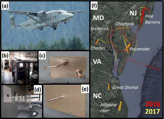
CARAFE: Regional Airborne Greenhouse Gases Eddy Covariance Measurements, 2016-2017
National Aeronautics and Space Administration —
This dataset provides airborne eddy covariance (EC) fluxes of carbon dioxide, methane, sensible heat, and latent heat at high spatial resolution collected during the... -
Federal
BOREAS TGB-05 CO2, CH4, and CO Chamber Flux Data over the NSA
National Aeronautics and Space Administration —
The BOREAS TGB-05 team collected a variety of trace gas concentration and flux measurements at several NSA sites. This data set contains carbon dioxide (CO2), methane... -
Federal
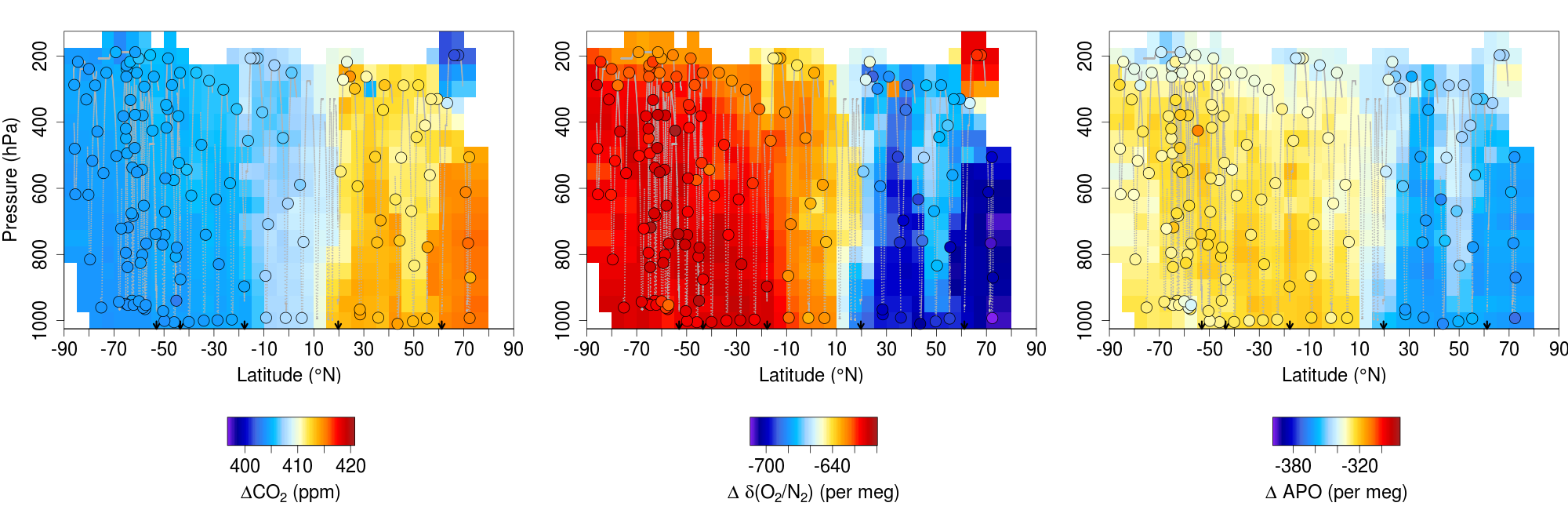
ATom: L2 In Situ Measurements from the NCAR Airborne Oxygen Instrument (AO2), V2
National Aeronautics and Space Administration —
This dataset provides in situ atmospheric oxygen and carbon dioxide concentrations measured by the NCAR Airborne Oxygen Instrument (AO2) during airborne campaigns... -
Federal
CALIPSO Lidar Level 3 Stratospheric Aerosol Profiles Standard V1-01
National Aeronautics and Space Administration —
CAL_LID_L3_Stratospheric_APro-Standard-V1-01 is the Cloud-Aerosol Lidar and Infrared Pathfinder Satellite Observation (CALIPSO) Lidar Level 3 Stratospheric Aerosol... -
Federal
TROPICS06 L1A Orbital Geolocated Native-Resolution Antenna Temperatures V1.0
National Aeronautics and Space Administration —
The "Time-Resolved Observations of Precipitation structure and storm Intensity with a Constellation of Smallsats" (TROPICS) mission has a goal of providing nearly... -
Federal
SAFARI 2000 GPCP Daily Precipitation, 1-Deg, 1999-2001
National Aeronautics and Space Administration —
The Global Precipitation Climatology Project (GPCP) is an international project designed to provide improved long-record estimates of precipitation over the globe.... -
Federal
TROPESS CrIS-SNPP L2 Carbon Monoxide for West Coast Fires HiRes, Standard Product V1 (TRPSDL2COCRSWCFHI) at GES DISC
National Aeronautics and Space Administration —
The TROPESS CrIS-SNPP L2 Carbon Monoxide for West Coast Fires HiRes, Standard Product contains the vertical distribution of the retrieved atmospheric state of carbon... -
Federal
BOREAS HYD-04 Standard Snow Course Data
National Aeronautics and Space Administration —
The BOREAS HYD-04 work was focused on collecting data during the winter field campaign (FFC-W) to improve the understanding of winter processes within the boreal... -
Federal
CARVE: Fire-Related Aerosol and Soil Elemental and Isotopic Composition, Alaska, 2013
National Aeronautics and Space Administration —
This data set provides measurements of the isotopic composition of black carbon and organic carbon aerosols collected at two locations in interior Alaska during the... -
Federal
BOREAS Follow-On DSP-10 Regridded Moss Cover Maps for 1994
National Aeronautics and Space Administration —
Existing 1-km moss cover classifications were reprocessed and are now available at multiple resolutions (2 km, 10x5 minutes, and 0.5 degree). These data were... -
Federal
OMI/Aura Level 1B VIS Zoom-in Geolocated Earthshine Radiances V004 (OML1BRVZ) at GES DISC
National Aeronautics and Space Administration —
The Aura Ozone Monitoring Instrument (OMI) Level 1B (L1B) Zoom-in Earthshine UV Radiance, Zoom-mode (shortname OML1BRVZ) Version 4 product contains geolocated Earth... -
Federal
NASMo-TiAM 250m 16-day North America Surface Soil Moisture Dataset
National Aeronautics and Space Administration —
This NASMo-TiAM (North America Soil Moisture Dataset Derived from Time-Specific Adaptable Machine Learning Models) dataset holds gridded estimates of surface soil... -
Federal
BOREAS TGB-05 Fire History of Manitoba 1980 to 1991 in Raster Format
National Aeronautics and Space Administration —
This raster format data set covers the province of Manitoba. The data were gridded into the AEAC projection from the original vector data. The original vector data... -
Federal
LBA-ECO CD-37 Secondary Forest Biomass and Age Class, Rondonia, Brazil
National Aeronautics and Space Administration —
This data set provides tree age, forest formation, and land cover classification maps, and estimates of landscape-level above-ground live woody biomass (AGLB) for...

Official websites use .gov
A
.gov website belongs to an official government
organization in the United States.
Secure .gov websites use HTTPS
A
lock (
) or https:// means you’ve safely connected to
the .gov website. Share sensitive information only on official,
secure websites.