
-
Federal
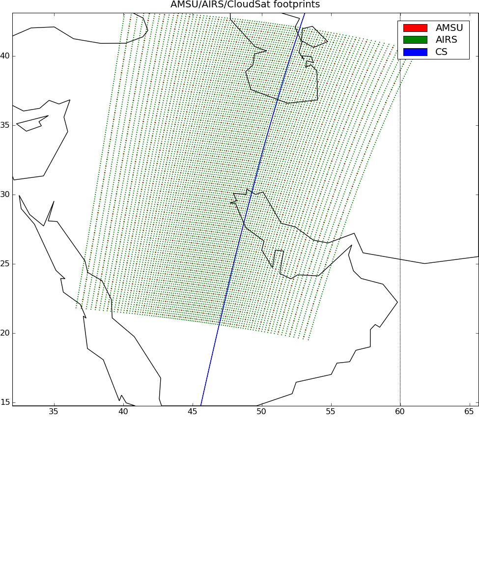
AIRS-CloudSat cloud mask, radar reflectivities, and cloud classification matchups V3.2 (AIRS_CPR_MAT) at GES DISC
National Aeronautics and Space Administration —
This is AIRS-CloudSat collocated subset, in NetCDF-4 format. These data contain collocated: AIRS Level 1b radiances spectra, CloudSat radar reflectivities, and MODIS... -
Federal
GPM VIRS on TRMM unpacked data L1A 1.5 hours 2 km V07 (GPM_1AVIRS) at GES DISC
National Aeronautics and Space Administration —
This is the new (GPM-formated) TRMM product. It replaces the old TRMM_1A01 Version 07 is the current version of the data set. Previous versions have been superseded... -
Federal
GPM ATMS on NOAA-20 (GPROF) Radiometer Precipitation Profiling L3 1 day 0.25 degree x 0.25 degree V07 (GPM_3GPROFNOAA20ATMS_DAY) at GES DISC
National Aeronautics and Space Administration —
Version 07 is the current version of the data set. Older versions will no longer be available and have been superseded by Version 07. 3GPROF products provide global... -
Federal
DSCOVR EPIC Level 2 Cloud Version 03
National Aeronautics and Space Administration —
DSCOVR_EPIC_L2_CLOUD_03 is the Deep Space Climate Observatory (DSCOVR) Earth Polychromatic Imaging Camera (EPIC) Level 2 Cloud version 03 data product. The EPIC Level... -
Federal
CERES BDS Terra FM1 Edition 4
National Aeronautics and Space Administration —
CER_BDS_Terra-FM1_Edition4 is the Clouds and the Earth's Radiant Energy System (CERES) Bidirectional Scans (BDS) Terra Flight Model 1 (FM1) Edition 4 data product,... -
Federal
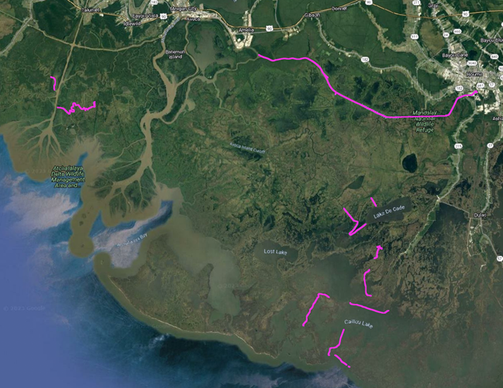
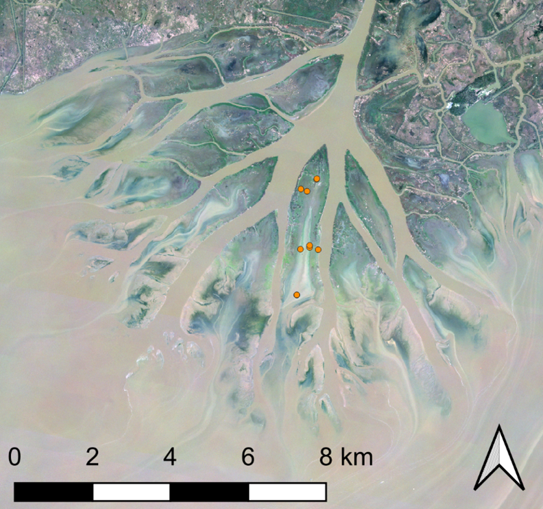
Delta-X: In-situ Water Surface Elevation, MRD, Louisiana, USA, 2021
National Aeronautics and Space Administration —
This dataset contains in situ water level measurements collected at 49 different locations across the Atchafalaya and Terrebonne basins in the Mississippi River Delta... -
Federal
Delta-X: Matlab Model for Wax Lake Delta Land Accretion
National Aeronautics and Space Administration —
This dataset provides the Matlab sediment transport and land accretion model at Wax Lake Delta (WLD), Atchafalaya Basin, in coastal Louisiana. The data include the... -
Federal
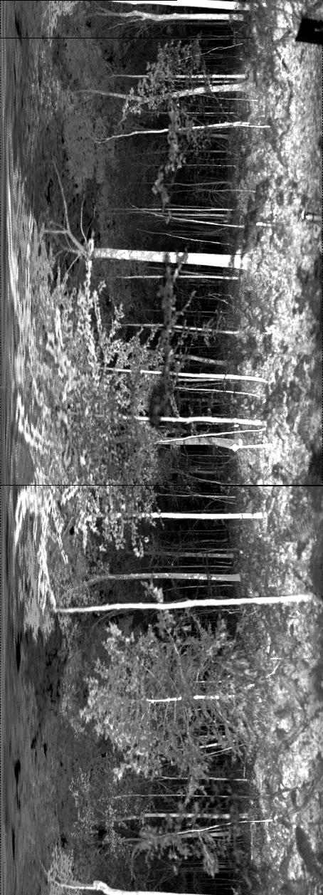
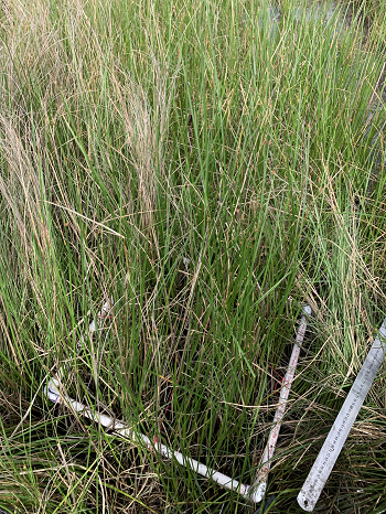
ECHIDNA LIDAR Campaigns: Forest Canopy Imagery and Field Data, U.S.A., 2007-2009
National Aeronautics and Space Administration —
This data set contains forest canopy scan data from the Echidna® Validation Instrument (EVI) and field measurements data from three campaigns conducted in the United... -
Federal
CERES A-Train Integrated CALIPSO, CloudSat, CERES, and MODIS (CCCM) Merged Release D1
National Aeronautics and Space Administration —
CER_CCCM_Aqua-FM3-MODIS-CAL-CS_RelD1 is the Clouds and the Earth's Radiant Energy System (CERES) A-Train Integrated Cloud-Aerosol Lidar and Infrared Pathfinder... -
Federal
CARVE: L2 Atmospheric CO2, CO and CH4 Concentrations, NOAA CRDS, Alaska, 2012-2015
National Aeronautics and Space Administration —
This data set provides atmospheric carbon dioxide (CO2), methane (CH4), carbon monoxide (CO), and water vapor (H2O) concentrations from airborne campaigns over the... -
Federal
BOREAS RSS-14 GOES-7 Level-1 Visible, Infrared, and Water Vapor Images
National Aeronautics and Space Administration —
The level-1 BOREAS GOES-7 image data were collected by Remote Sensing Science Team 14 (RSS-14) personnel at Florida State University (FSU) and delivered to BORIS. The... -
Federal
BOREAS RSS-11 Ground Sunphotometer Data
National Aeronautics and Space Administration —
The BOREAS RSS-11 team operated a network of five automated (Cimel) and two hand-held (Miami) solar radiometers from 1994 to 1996 during the BOREAS field campaigns.... -
Federal
ACT-America: Gridded Ensembles of Surface Biogenic Carbon Fluxes, 2003-2019
National Aeronautics and Space Administration —
This data set provides gridded, model-derived gross primary productivity (GPP), ecosystem respiration (RECO), and net ecosystem exchange (NEE) of CO2 biogenic fluxes... -
Federal
CERES ERBE-like Instantaneous TOA Estimates Aqua FM4 Edition4
National Aeronautics and Space Administration —
CER_ES8_Aqua-FM4_Edition4 is the Clouds and the Earth's Radiant Energy System (CERES) Earth Radiation Budget Experiment (ERBE)-like Instantaneous Top-of-the-... -
Federal
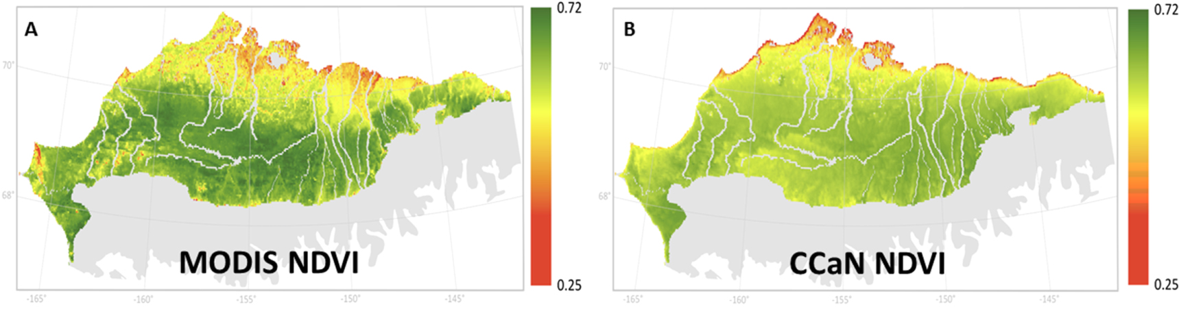
ABoVE: MODIS- and CCAN-Derived NDVI and Trends, North Slope of Alaska, 2000-2015
National Aeronautics and Space Administration —
This dataset provides the average Normalized Difference Vegetation Index (NDVI) at 1-km resolution over the north slope of Alaska, USA, for the growing season (June-... -
Federal
CALIPSO Lidar Level 2 Cloud Profile, V4-21
National Aeronautics and Space Administration —
CAL_LID_L2_05kmCPro-Standard-V4-21 is the Cloud-Aerosol Lidar and Infrared Pathfinder Satellite Observations (CALIPSO) Lidar Level 2 Cloud Profile, Version 4-21 data... -
Federal
Delta-X: Sediment Core Grain Size Distribution, Wax Lake Delta, MRD, LA
National Aeronautics and Space Administration —
This dataset provides grain size distribution measurements collected from sediment core samples on Mike Island in the Wax Lake Delta, Louisiana, as part of the... -
Federal
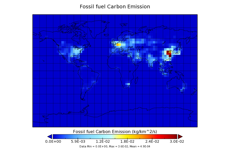
Carbon Monitoring System Flux for Fossil Fuel L4 V1 (CMSFluxFossilfuel) at GES DISC
National Aeronautics and Space Administration —
This dataset provides the Carbon Flux for Fossil Fuel.The NASA Carbon Monitoring System (CMS) is designed to make significant contributions in characterizing,... -
Federal
CALIPSO Lidar Level 1B profile data, V4-11
National Aeronautics and Space Administration —
CAL_LID_L1-Standard-V4-11 is the Cloud-Aerosol Lidar and Infrared Pathfinder Satellite Observation (CALIPSO) Lidar Level 1B profile data, Version 4-10 data product....

Official websites use .gov
A
.gov website belongs to an official government
organization in the United States.
Secure .gov websites use HTTPS
A
lock (
) or https:// means you’ve safely connected to
the .gov website. Share sensitive information only on official,
secure websites.