
-
Federal
ASTER Global Emissivity Dataset, 1 kilometer, HDF5 V003
National Aeronautics and Space Administration —
The Terra Advanced Spaceborne Thermal Emission and Reflection Radiometer (ASTER) Global Emissivity Dataset (GED) land surface temperature and emissivity (LST&E)... -
Federal
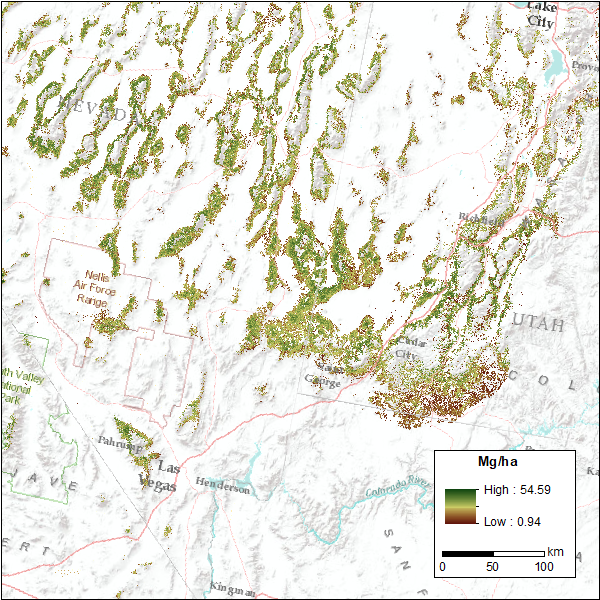
CMS: Pinyon-Juniper Forest Live Aboveground Biomass, Great Basin, USA, 2000-2016
National Aeronautics and Space Administration —
This dataset provides annual maps of live aboveground tree biomass (Mg/ha) for pinyon-juniper forests across the Great Basin of the Western USA for the years... -
Federal
Inventory of Rock Glaciers along the Ghunsa Valley, Kanchanjunga Himal, Eastern Nepal, Version 1
National Aeronautics and Space Administration —
This dataset provides information on a number of Nepali rock glaciers distributed above 4250 m ASL along the Ghunsa valley and the Kanchanjunga glacier (originating... -
Federal
Chiniak, Alaska 8/15 arc-second Coastal Digital Elevation Model
National Oceanic and Atmospheric Administration, Department of Commerce —
NOAA's National Centers for Environmental Information is building high-resolution digital elevation models (DEMs) to support individual coastal States as part of the... -
Federal
2022 NOAA NGS Topobathy Lidar of Tutuila, American Samoa
National Oceanic and Atmospheric Administration, Department of Commerce —
This data was collected by Woolpert using a Leica HawkEye 4X sensor. The data was acquired from 20221018 - 20221212. The data includes topobathy data in LAS 1.4... -
Federal
2017 NOAA NGS Topobathy Lidar: St. Jeromes Creek, MD
National Oceanic and Atmospheric Administration, Department of Commerce —
This data was collected by NOAA using a Riegl VQ880G sensor. The data was acquired April 9, 2017. The data includes topobathy data in LAS 1.2 format classified as... -
Federal
2016 NOAA NGS Topobathy Lidar DEM: Tarpon Springs (FL)
National Oceanic and Atmospheric Administration, Department of Commerce —
This data was collected by NOAA using a Riegl VQ880G sensor. The data was acquired from February 11, 2016 through February 14, 2016. The data includes topobathy data... -
Federal
1997 Fall West Coast NOAA/USGS/NASA Airborne LiDAR Assessment of Coastal Erosion (ALACE) Project for the US Coastline
National Oceanic and Atmospheric Administration, Department of Commerce —
This data set includes data collected in the fall of 1997 and covers the states of California, Oregon, and Washington. Collection was done prior to expected El Nino... -
Federal
2015 NOAA NGS Topobathy Lidar: Buzzards Bay Block3 (MA)
National Oceanic and Atmospheric Administration, Department of Commerce —
These data were collected by the National Oceanic Atmospheric Administration National Geodetic Survey Remote Sensing Division using a Riegl VQ880G system. The data... -
Federal
2010 Northwestern Hawaiian Islands Lidar - Lisianki Island
National Oceanic and Atmospheric Administration, Department of Commerce —
The U.S. Geological Survey (USGS) contracted with Hawaii-based Aerial Surveying, Inc. to collect lidar-derived elevation data over the low-lying areas within the... -
Federal
2012 NOAA American Samoa Lidar DEM: Islands of Tutuila, Aunu'u, Ofu, Olosega, Ta'u and Rose Atoll
National Oceanic and Atmospheric Administration, Department of Commerce —
Light Detection and Ranging (LiDAR) data is remotely sensed high-resolution elevation data collected by an airborne collection platform. This LiDAR dataset is a... -
Federal
2016-2017 NOAA NGS Topobathy: Coastal South Carolina
National Oceanic and Atmospheric Administration, Department of Commerce —
These data were collected by Quantum Spatial, Inc. (QSI) for the National Oceanic and Atmospheric Administration (NOAA), National Geodetic Survey (NGS), Remote... -
Federal
2022 NOAA NGS Topobathy Lidar DEM of Faleasao, American Samoa
National Oceanic and Atmospheric Administration, Department of Commerce —
This data was collected by Woolpert using a Leica HawkEye 4X sensor. The data was acquired on 20221021. The data includes topobathy data in LAS 1.4 format classified... -
Federal
H11617, NOS Hydrographic Survey in the vicinity of Mississippi Sound, Mississippi (2007)
National Oceanic and Atmospheric Administration, Department of Commerce —
The National Oceanic and Atmospheric Administration (NOAA) has the statutory mandate to collect hydrographic data in support of nautical chart compilation for safe...

Official websites use .gov
A
.gov website belongs to an official government
organization in the United States.
Secure .gov websites use HTTPS
A
lock (
) or https:// means you’ve safely connected to
the .gov website. Share sensitive information only on official,
secure websites.