

1,032 datasets found for "Conservation"
-
Federal
Sensitivity of Coastal Environments and Wildlife to Spilled Oil: Upper Coast of Texas: MGT (Management Area Polygons)
National Oceanic and Atmospheric Administration, Department of Commerce —
This data set contains sensitive human-use data for aquaculture sites, Designated Critical Habitats, management areas, Nature Conservancy properties, parks, and... -
Federal
Oceanographic Trawl Data - Juvenile Salmon & Ocean Ecosystem Survey
National Oceanic and Atmospheric Administration, Department of Commerce —
FY20 will mark the 23nd year of sampling, making the Juvenile Salmon and Ocean Ecosystem Survey (JSOES) the longest running salmon survey on the west coast. JSOES has... -
Federal
Digital Geohazards-GIS Map of John Muir National Historic Site and Vicinity, California (NPS, GRD, GRI, JOMU, JOMU_geohazard digital map) adapted from a California Department of Conservation, Division of Mines and Geology Open-File Report map by Haydon (1995)
Department of the Interior —
The Digital Geologic-GIS Map of John Muir National Historic Site and Vicinity, California is composed of GIS data layers and GIS tables, and is available in the... -
Federal
Digital Geologic-GIS Map of the Whistle Creek NW Quadrangle, Nebraska (NPS, GRD, GRI, AGFO, WHCR digital map) adapted from a University of Nebraska Conservation and Survey Division Geologic Maps and Charts map by Dillon, Hanson and Howard (2013)
Department of the Interior —
The Digital Geologic-GIS Map of the Whistle Creek NW Quadrangle, Nebraska is composed of GIS data layers and GIS tables, and is available in the following GRI-... -
Federal
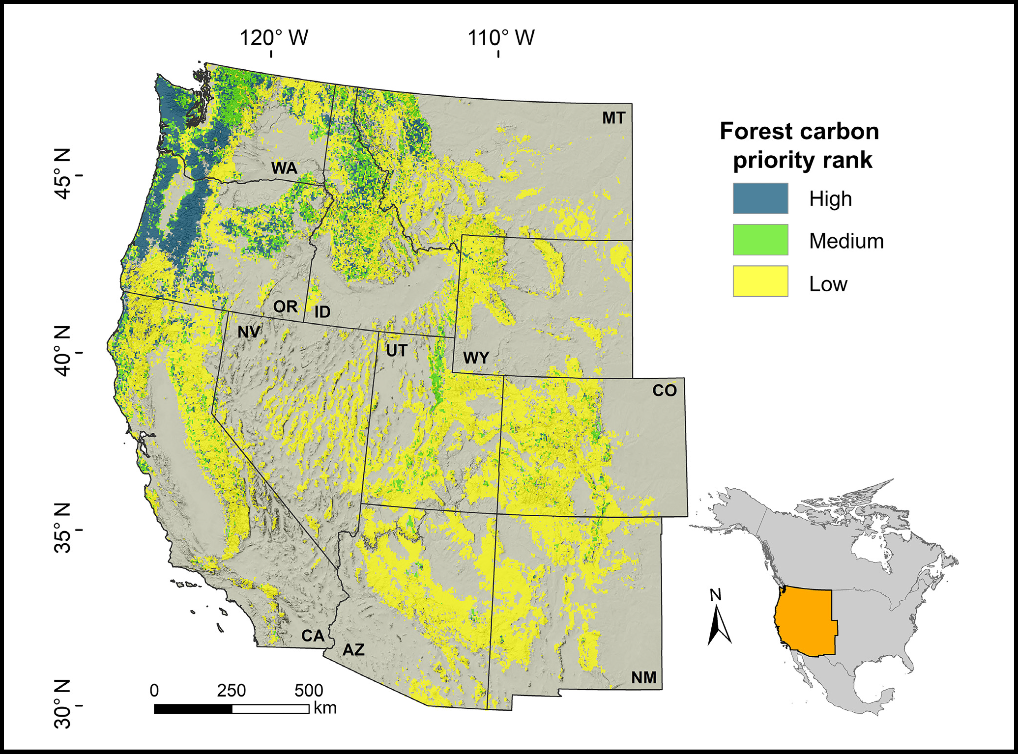
Forest Preservation Ranking and Vertebrate Species Richness, Western USA, 2020-2099
National Aeronautics and Space Administration —
This dataset provides related gridded outputs of future modeled forest carbon sequestration priority and related species richness and habitat suitability for the... -
Federal
ECOSTRESS Cloud Mask Daily L2 Global 70m V001
National Aeronautics and Space Administration —
The ECO2CLD Version 1 data product was decommissioned on May 21, 2025. Users are encouraged to use theFederalDemonstration of the Sequence Alignment to Predict Across Species Susceptibility Tool for Rapid Assessment of Protein Conservation
U.S. Environmental Protection Agency —
Data file for "Vliet SMF, Hazemi M, Blatz D, Jensen M, Mayasich S, Transue TR, Simmons C, Wilkinson A, LaLone CA. Demonstration of the Sequence Alignment to Predict...FederalToxicity by descent: a comparative approach for chemical hazard assessment
U.S. Environmental Protection Agency —
Data for "John K. Colbourne, Joseph R. Shaw, Elena Sostare, Claudia Rivetti, Romain Derelle, Rosemary Barnett, Bruno Campos, Carlie LaLone, Mark R. Viant, Geoff...FederalDigital Geologic-GIS Map of John Muir National Historic Site and Vicinity, California (NPS, GRD, GRI, JOMU, JOMU digital map) adapted from a California Department of Conservation, Division of Mines and Geology Open-File Report map by Haydon (1995)
Department of the Interior —
The Digital Geologic-GIS Map of John Muir National Historic Site and Vicinity, California is composed of GIS data layers and GIS tables, and is available in the...FederalWater quality modeling in the dead end sections of drinking water (Supplement)
U.S. Environmental Protection Agency —
Dead-end sections of drinking water distribution networks are known to be problematic zones in terms of water quality degradation. Extended residence time due to...1,032 datasets found for "Conservation"