
-
Federal
ICON The Far Ultra Violet Imaging Spectrograph Nightside Images
National Aeronautics and Space Administration —
The FUV instrument takes 2D images of the Earth’s horizon in the Far ultraviolet. The imager is pointing approximately 90 degrees to the spacecraft motion, similar to... -
Federal
TOLNet NASA Goddard Space Flight Center Data
National Aeronautics and Space Administration —
TOLNet_GSFC_Data is the lidar data collected by the Tropospheric Ozone (TROPOZ) lidar at the Goddard Space Flight Center (GSFC) as part of the Tropospheric Ozone... -
Federal
LBA-ECO CD-04 Meteorological and Flux Data, km 83 Tower Site, Tapajos National Forest
National Aeronautics and Space Administration —
We used two independent approaches, biometry and micrometeorology, to determine the net ecosystem production (NEP) of an old growth forest in Para, Brazil. Biometric... -
Federal
TOLNet City College of New York Data
National Aeronautics and Space Administration —
TOLNet_CCNY_Data is the lidar data collected by the New York Tropospheric Ozone Lidar System (NYTOLS) at the City College of New York (CCNY) as part of the... -
Federal
TOLNet Environment and Climate Change Canada Data
National Aeronautics and Space Administration —
TOLNet_ECCC_Data is the lidar data collected by the Autonomous Mobile Ozone LIDAR instrument for Tropospheric Experiments (AMOLITE) lidar at Environment and Climate... -
Federal
TOLNet NOAA Chemical Sciences Laboratory Data
National Aeronautics and Space Administration —
TOLNet_CSL_Data is the lidar data collected by the Tunable Optical Profile for Aerosol and oZone (TOPAZ) lidar at the NOAA Chemical Sciences Laboratory (CSL) in... -
Federal
GHRSST Level 2P Western Atlantic Regional Skin Sea Surface Temperature from the Geostationary Operational Environmental Satellites (GOES) Imager on the GOES-13 satellite (GDS version 2)
National Aeronautics and Space Administration —
The Geostationary Operational Environmental Satellites (GOES) operated by the United States National Oceanic and Atmospheric Administration (NOAA) support weather... -
Federal
GHRSST Level 2P Central Pacific Regional Skin Sea Surface Temperature from the Geostationary Operational Environmental Satellites (GOES) Imager on the GOES-15 satellite (GDS version 2)
National Aeronautics and Space Administration —
The Geostationary Operational Environmental Satellites (GOES) operated by the United States National Oceanic and Atmospheric Administration (NOAA) support weather... -
Federal
JUNO JUPITER UVS 2 EXPERIMENT DATA RECORD V1.0
National Aeronautics and Space Administration —
The Juno Ultraviolet Spectrograph (UVS) CODMAC Level 2 Experiment Data Recordis a collection of the far ultraviolet photon detections obtained by the UVSinstrument,... -
Federal
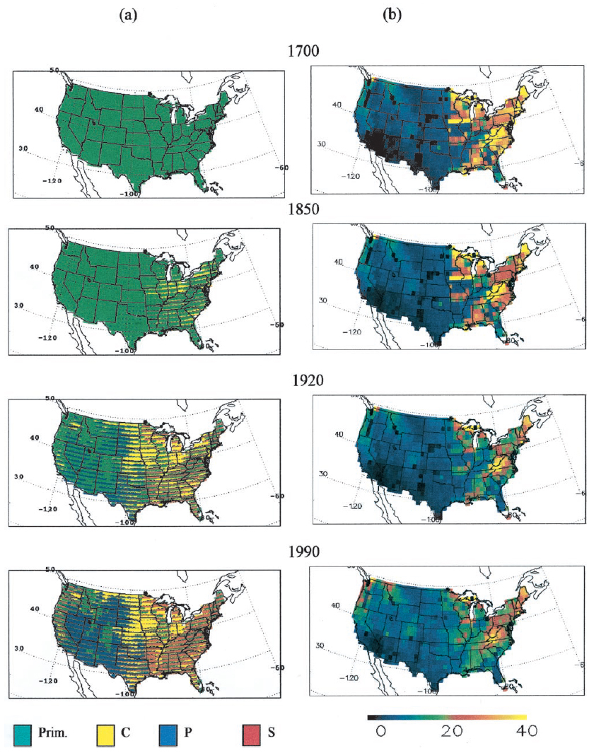
Ecosystem Demography Model: U.S. Ecosystem Carbon Stocks and Fluxes, 1700-1990
National Aeronautics and Space Administration —
This model product contains the source code for the Ecosystem Demography Model (ED version 1.0) as well as model input and output data files for the conterminous... -
Federal
California Pronghorn Bodie-Wassuk Migration Corridors
Department of the Interior —
The Bodie-Wassuk pronghorn (Antilocapra americana) herd contains migrants, but this herd does not migrate between traditional summer and winter seasonal ranges.... -
Federal
High frequency of phenotypic deviations in
U.S. Department of Health & Human Services —
Background The moss Physcomitrella patens is an attractive model system for plant biology and functional genome analysis. It shares many biological features with... -
Federal
PFASs in tree swallows in the Upper Midwest
Department of the Interior —
The exposure and effects of perfluoroalkyl substances (PFASs) were studied at eight locations in Minnesota and Wisconsin between 2007and 2011 using tree swallows... -
Federal
California Pronghorn Bodie-Wassuk Migration Routes
Department of the Interior —
The Bodie-Wassuk pronghorn (Antilocapra americana) herd contains migrants, but this herd does not migrate between traditional summer and winter seasonal ranges.... -
Federal
Chandra Serendipitous Extragalactic X-Ray Source ID (SEXSI)/Spitzer AGN Catalog
National Aeronautics and Space Administration —
The authors compare the relative merits of active galactic nuclei (AGN) selection at X-ray and mid-infrared wavelengths using data from moderately deep fields... -
Federal
ICON The Far Ultra Violet Imaging Spectrograph Dayside Images
National Aeronautics and Space Administration —
The FUV instrument takes 2D images of the Earth’s horizon in the Far ultraviolet. The imager is pointing approximately 90 degrees to the spacecraft motion, similar to... -
Federal
Umpqua River Oregon Aerial Photograph Data for 1967
Department of the Interior —
The Umpqua River drains 12,103 square kilometers (4,673 square miles) in southwest Oregon before flowing into the Pacific Ocean at Winchester Bay near the city of... -
Federal
AIRS/Aqua L1B Near Real Time (NRT) Infrared (IR) geolocated and calibrated radiances in BUFR format V005 (AIRIBRAD_NRT_BUFR) at GES DISC
National Aeronautics and Space Administration —
WARNING: On 2021/09/23 the EOS Aqua executed a Deep Space Maneuver (DSM). In the DSM, the spacecraft is turned such that the normal Earth field of regard is deep... -
Federal
Herschel Space Observatory Log of Observations
National Aeronautics and Space Administration —
The Herschel Space Observatory (Herschel) is an ESA (European Space Agency) project with instruments funded by ESA member states. It was operated from May 2009 till... -
Federal
Pro/con ethics debate: Should mechanical ventilation be continued to allow for progression to brain death so that organs can be donated?
U.S. Department of Health & Human Services —
Organ transplants continue to redefine medical frontiers. Unfortunately, current demand for organs far surpasses availability, waiting lists are long and many people...

Official websites use .gov
A
.gov website belongs to an official government
organization in the United States.
Secure .gov websites use HTTPS
A
lock (
) or https:// means you’ve safely connected to
the .gov website. Share sensitive information only on official,
secure websites.