
-
Federal
TOVS GLA DAILY GRIDS from NOAA-11 V01 (TOVSADNH) at GES DISC
National Aeronautics and Space Administration —
This dataset (TOVSADNH) contains the TIROS Operational Vertical Sounder (TOVS) level 3 geophysical parameters derived using data from NOAA-11 and the physical... -
Federal
Snow Melt Onset Over Arctic Sea Ice from SMMR and SSM/I-SSMIS Brightness Temperatures, Version 5
National Aeronautics and Space Administration —
This data set includes yearly snow melt onset dates over Arctic sea ice derived from Scanning Multichannel Microwave Radiometer (SMMR), Special Sensor... -
Federal
Geostationary Lightning Mapper (GLM) Combined Monthly Thunder Hour Data Product
National Aeronautics and Space Administration —
The Geostationary Lightning Mapper (GLM) is the first optical lightning detector in geostationary orbit, and GLM sensors operate aboard the National Oceanic and... -
Federal
Ground-Based Global Navigation Satellite System Data (30-second sampling, 24 hour files) from NASA CDDIS
National Aeronautics and Space Administration —
GNSS provide autonomous geo-spatial positioning with global coverage. GNSS data sets from ground receivers at the CDDIS consist primarily of the data from the U.S.... -
Federal
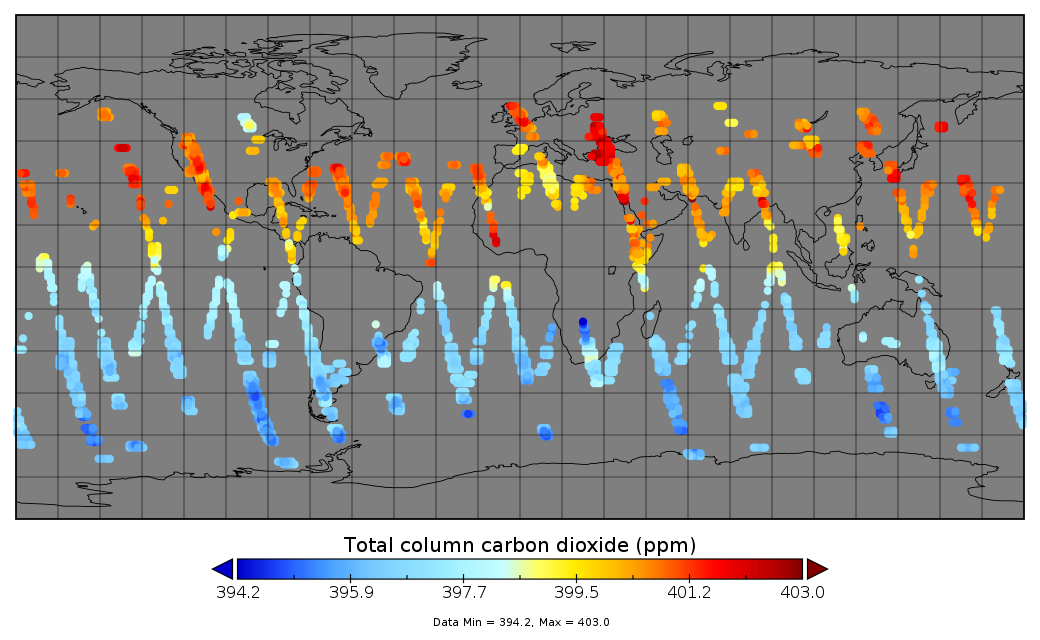
Multi-Instrument Fused bias-corrected XCO2 and other select fields aggregated as Level 4 daily files V3 (MultiInstrumentFusedXCO2)
National Aeronautics and Space Administration —
Gridded carbon dioxide mole fraction (XCO2) and other select variables created by applying local kriging (also known as optimal interpolation) to daily aggregates of... -
Federal
NACP Aboveground Biomass and Carbon Baseline Data, V.2 (NBCD 2000), U.S.A., 2000
National Aeronautics and Space Administration —
The NBCD 2000 (National Biomass and Carbon Dataset for the Year 2000) data set provides a high-resolution (30 m) map of year-2000 baseline estimates of basal area-... -
Federal
ASTER L2 Surface Radiance TIR V004
National Aeronautics and Space Administration —
The Terra Advanced Spaceborne Thermal Emission and Reflection Radiometer (ASTER) Surface Radiance TIR (AST_09T) is generated using the five Thermal Infrared (TIR)... -
Federal
MODIS/Terra Gross Primary Productivity Gap-Filled 8-Day L4 Global 500m SIN Grid V006
National Aeronautics and Space Administration —
The MOD17A2HGF Version 6 data product was decommissioned on July 31, 2023. Users are encouraged to use theFederalGlobal Navigation Satellite System (GNSS) Satellite Data from NASA CDDIS
National Aeronautics and Space Administration —
Global Navigation Satellite System (GNSS) data consists of the U.S. Global Positioning System (GPS) and the Russian GLObal NAvigation Satellite System (GLONASS) (plus...FederalSnowfall and Snow Depth for Canada 1943-1982, Version 1
National Aeronautics and Space Administration —
Data include monthly snowfall and end-of-month snow depth for 140 stations across Canada. Stations that maintained at least 20 years of data were chosen. The original...FederalSentinel-1C Dual Polarization Full Resolution Ground Range Detected Product Metadata
National Aeronautics and Space Administration —
The Sentinel-1C satellite was launched December 5, 2024. Sentinel-1C is the the latest satellite to be added to the Sentinel-1 constellation. The Sentinel-1...FederalGlobal MODIS and FLUXNET-derived Daily Gross Primary Production, V2
National Aeronautics and Space Administration —
This dataset provides global gridded daily estimates of gross primary production (GPP) and uncertainties at 0.05-degree resolution for the period 2000-03-01 to the...FederalOcean Surface Current Analyses Real-time (OSCAR) Surface Currents - Interim 0.25 Degree (Version 2.0)
National Aeronautics and Space Administration —
Ocean Surface Current Analyses Real-time (OSCAR) is a global surface current database and NASA funded research project. OSCAR ocean mixed layer velocities are...FederalPlanetScope Satellite Imagery 3 Band Scene
National Aeronautics and Space Administration —
The Planet Scope 3 band collection contains satellite imagery obtained from Planet Labs, Inc by the Commercial SmallSat Data Acquisition (CSDA) Program. This...FederalAIRS/Aqua L3 Monthly Support Product (AIRS+AMSU) 1 degree x 1 degree V006 (AIRX3SPM) at GES DISC
National Aeronautics and Space Administration —
The Atmospheric Infrared Sounder (AIRS) is a grating spectrometer (R = 1200) aboard the second Earth Observing System (EOS) polar-orbiting platform, EOS Aqua. In...FederalGPM SSMIS on F16 (GPROF) Climate-based Radiometer Precipitation Profiling L3 1 month 0.25 degree x 0.25 degree V07 (GPM_3GPROFF16SSMIS_CLIM) at GES DISC
National Aeronautics and Space Administration —
Version 07 is the current version of the data set. Older versions will no longer be available and have been superseded by Version 07. The "CLIM" products differ from...FederalMLS/Aura Level 3 Daily Binned Geopotential Height (GPH) on Zonal and Similar Grids V005 (ML3DZGPH) at GES DISC
National Aeronautics and Space Administration —
ML3DZGPH is the EOS Aura Microwave Limb Sounder (MLS) daily binned on zonal and assorted vertical grids product for geopotential height (GPH) derived from radiances...FederalBOREAS TF-10 NSA-YJP Tower Flux, Meteorological, and Porometry Data
National Aeronautics and Space Administration —
The BOREAS TF-10 team collected tower flux and meteorological data at two sites, a fen and a young jack pine forest, near Thompson, Manitoba, Canada, as part of...FederalCAMEX-3 ATMOSPHERIC EMITTED RADIANCE INTERFEROMETER (AERI) V1
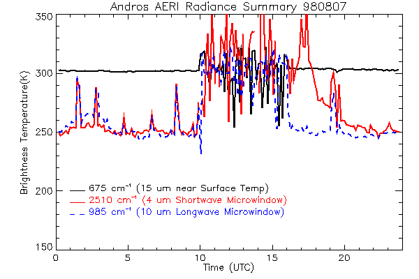
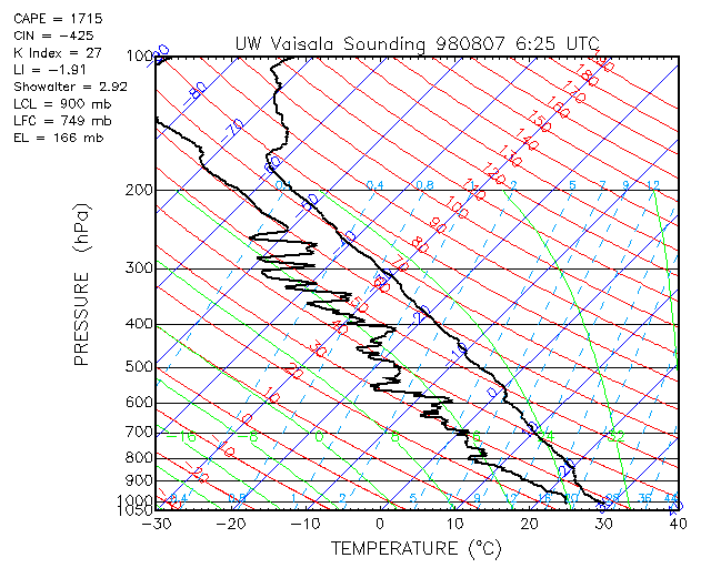
National Aeronautics and Space Administration —
The Atmospheric Emitted Radiance Interferometer (AERI) was used to make atmospheric temperature and moisture retrievals. AERI provides absolutely calibrated radiances...9,584 datasets found

Official websites use .gov
A
.gov website belongs to an official government
organization in the United States.
Secure .gov websites use HTTPS
A
lock (
) or https:// means you’ve safely connected to
the .gov website. Share sensitive information only on official,
secure websites.