
-
Federal
maracoos_05-20241011T1741-delayed
National Oceanic and Atmospheric Administration, Department of Commerce —
This project supports the deployment and real-time data delivery of autonomous underwater gliders in the coastal ocean to better resolve and understand essential... -
Federal
ud_134-20200731T2103
National Oceanic and Atmospheric Administration, Department of Commerce —
This project supports the deployment and realtime data delivery of autonomous underwater gliders in the coastal ocean to better resolve and understand essential ocean... -
Federal
ru30-20140422T1743-delayed
National Oceanic and Atmospheric Administration, Department of Commerce —
Slocum glider dataset gathered as part of the TEMPESTS (The Experiment to Measure and Predict East coast STorm Strength), funded by NOAA through CINAR (Cooperative... -
Federal
maracoos_05-20240801T1650-delayed
National Oceanic and Atmospheric Administration, Department of Commerce —
This project supports the deployment and real-time data delivery of autonomous underwater gliders in the coastal ocean to better resolve and understand essential... -
Federal
Ground-Based GNSS-based Upper Atmospheric Realtime Disaster Information and Alert Network (GUARDIAN) GPS daily accumulated real-time Precise Orbit Determination (POD) orbits (60-second sampling, 24-hour files) from NASA CDDIS
National Aeronautics and Space Administration —
This product contains a time series of position and velocity components for healthy satellites in the GPS constellation that are accumulated every minute throughout... -
Federal
Ground-Based Global Navigation Satellite System (GNSS)-based Upper Atmospheric Realtime Disaster Information and Alert Network (GUARDIAN) GLONASS daily antenna phase maps (meta data, 24-hour files) from NASA CDDIS
National Aeronautics and Space Administration —
This product contains file names and URLs to files containing antenna phase map data used in the real-time GLONASS POD processing. In particular, the IGS ANTEX file... -
Federal
Ground-Based Global Navigation Satellite System (GNSS)-based Upper Atmospheric Realtime Disaster Information and Alert Network (GUARDIAN) GLONASS Earth Orientation Parameters (1-day sampling, 7-day files) from NASA CDDIS
National Aeronautics and Space Administration —
This product contains a time series of Earth orientation parameters from the IERS Bulletin A for the GLONASS constellation of satellites. The product is generated at... -
Federal
Ground-Based Global Navigation Satellite System (GNSS)-based Upper Atmospheric Realtime Disaster Information and Alert Network (GUARDIAN) GLONASS daily antenna phase centers (24-hour files) from NASA CDDIS
National Aeronautics and Space Administration —
This product contains antenna phase center locations relative to the GLONASS satellite's center of mass. The product is generated at JPL's Global Differential GPS... -
Federal
Ground-Based GNSS-based Upper Atmospheric Realtime Disaster Information and Alert Network (GUARDIAN) GLONASS daily accumulated real-time Precise Orbit Determination (POD) Clock Corrections (1-second sampling, 24-hour files) from NASA CDDIS
National Aeronautics and Space Administration —
This product contains a high-rate time series of clock biases for healthy satellites in the GLONASS constellation that are accumulated every minute throughout the... -
Federal
Ground-Based GNSS-based Upper Atmospheric Realtime Disaster Information and Alert Network (GUARDIAN) GLONASS daily accumulated real-time Precise Orbit Determination (POD) Attitude Quaternions (30-second sampling, 24-hour files) from NASA CDDIS
National Aeronautics and Space Administration —
This product contains a time series of attitude quaternion components for healthy satellites in the GLONASS constellation that are accumulated every minute throughout... -
Federal
Ground-Based GNSS-based Upper Atmospheric Realtime Disaster Information and Alert Network (GUARDIAN) Galileo daily accumulated real-time Precise Orbit Determination (POD) Clock Corrections (1-second sampling, 24-hour files) from NASA CDDIS
National Aeronautics and Space Administration —
This product contains a time series of clock biases for healthy satellites in the Galileo constellation that are accumulated every minute throughout the day. In... -
Federal
Ground-Based GNSS-based Upper Atmospheric Realtime Disaster Information and Alert Network (GUARDIAN) Galileo daily accumulated real-time Precise Orbit Determination (POD) orbits (60-second sampling, 24-hour files) from NASA CDDIS
National Aeronautics and Space Administration —
This product contains a time series of position and velocity components for healthy satellites in the Galileo constellation that are accumulated every minute... -
Federal
West Africa Coastal Vulnerability Mapping: Demographic and Health Survey Data Sets
National Aeronautics and Space Administration —
The West Africa Coastal Vulnerability Mapping: Demographic and Health Survey Data Sets present grids of maternal education levels and household wealth based on... -
Federal
ru30-20140702T2329-delayed
National Oceanic and Atmospheric Administration, Department of Commerce —
Slocum glider dataset gathered as part of the TEMPESTS (The Experiment to Measure and Predict East coast STorm Strength), funded by NOAA through CINAR (Cooperative... -
Federal
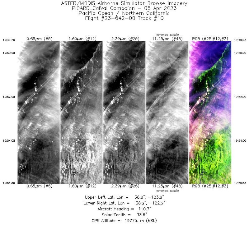
MASTER: Western Diversity Time Series Campaign, WDTS, Spring 2023
National Aeronautics and Space Administration —
This dataset includes Level 1B (L1B) and Level 2 (L2) data products from the MODIS/ASTER Airborne Simulator (MASTER) instrument. The spectral data were collected as... -
Federal
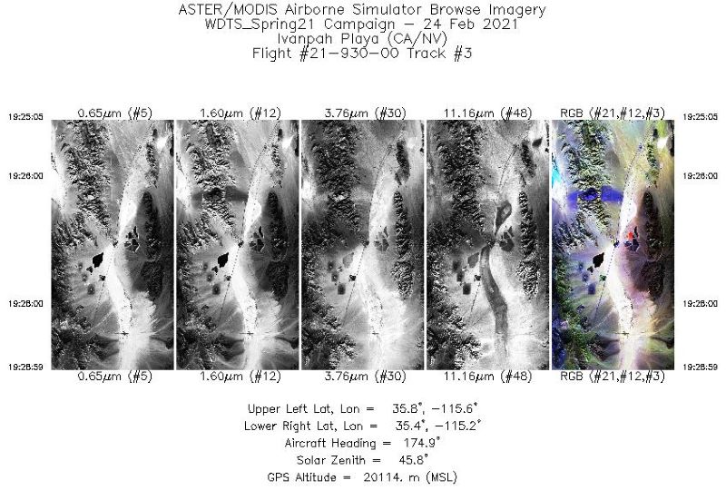
MASTER: Western Diversity Time Series Campaign, WDTS, California, USA, Spring 2021
National Aeronautics and Space Administration —
This dataset includes Level 1B (L1B) and Level 2 (L2) data products from the MODIS/ASTER Airborne Simulator (MASTER) instrument. The spectral data were collected as... -
Federal
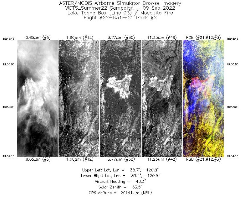
MASTER: Western Diversity Time Series Campaign, WDTS, September 2022
National Aeronautics and Space Administration —
This dataset includes Level 1B (L1B) and Level 2 (L2) data products from the MODIS/ASTER Airborne Simulator (MASTER) instrument. The spectral data were collected as... -
Federal
2020 NOAA NGS Ortho-rectified Color Mosaic Hurricane Florence: NC, SC, and VA
National Oceanic and Atmospheric Administration, Department of Commerce —
This data set contains ortho-rectified mosaic tiles, created as a product from the NOAA Integrated Ocean and Coastal Mapping (IOCM) initiative. The source imagery was... -
Federal
ru33-20200715T1558
National Oceanic and Atmospheric Administration, Department of Commerce —
This project supports the deployment and realtime data delivery of autonomous underwater gliders in the coastal ocean to better resolve and understand essential ocean... -
Federal
SG609-20150206T1720
National Oceanic and Atmospheric Administration, Department of Commerce —
Seaglider data gathered as part of the Sustained Ocean Observations for Improving Atlantic Tropical Cyclone Intensity and Hurricane Seasonal Forecast project funded...

Official websites use .gov
A
.gov website belongs to an official government
organization in the United States.
Secure .gov websites use HTTPS
A
lock (
) or https:// means you’ve safely connected to
the .gov website. Share sensitive information only on official,
secure websites.