
-
Federal
Full resolution and low resolution real-time physical trajectory profile data from gliders submitted to NCEI by the IOOS National Glider Data Assembly Center (NGDAC) from 2009-05-17 to present
National Oceanic and Atmospheric Administration, Department of Commerce —
This collection includes full resolution and low resolution real-time physical trajectory profile data from gliders deployed by various institutions in seas world-... -
Federal
Multibeam collection for KM1006: Multibeam data collected aboard Kilo Moana from 04-Apr-10 to 14-Apr-10, Apra, Guam to Suva, Fiji
National Oceanic and Atmospheric Administration, Department of Commerce —
This data set is part of a larger set of data called the Multibeam Bathymetry Database (MBBDB) where other similar data can be found -
Federal
"NEGOM CTD - n4l02s00.nc - 29.79N, 88.75W - 1998-11-23"
National Oceanic and Atmospheric Administration, Department of Commerce —
The Northeastern Gulf of Mexico Physical Oceanography Program (NEGOM) is supported by the Minerals Management Service (MMS) of the U.S. Department of the Interior.... -
Federal
Multibeam collection for B00128: Multibeam data collected aboard Surveyor from 06-Apr-88 to 25-Apr-88, Seattle, Washington to Seattle, Washington
National Oceanic and Atmospheric Administration, Department of Commerce —
This data set is part of a larger set of data called the Multibeam Bathymetry Database (MBBDB) where other similar data can be found -
Federal
Multibeam collection for EW0406: Multibeam data collected aboard Maurice Ewing from 23-Jun-04 to 09-Jul-04, Tampa, Florida to San Diego, California
National Oceanic and Atmospheric Administration, Department of Commerce —
This data set is part of a larger set of data called the Multibeam Bathymetry Database (MBBDB) where other similar data can be found -
Federal
SGS-LTER Long-term Monitoring Project: Spotlight Rabbit Count on the Central Plains Experimental Range, Nunn, Colorado, USA 1994-2006, ARS Study Number 98
Department of Agriculture —
This data package was produced by researchers working on the Shortgrass Steppe Long Term Ecological Research (SGS-LTER) Project, administered at Colorado State... -
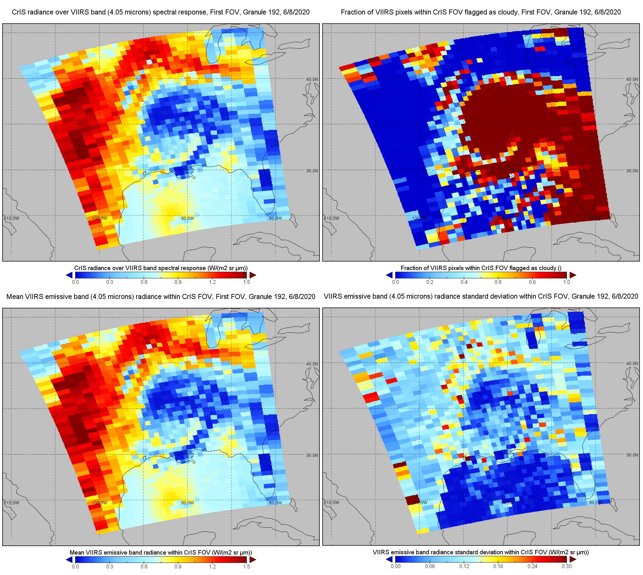
Federal
S-NPP CrIS IMG: Collocated VIIRS level 1 / cloud mask statistical summary V2 (SNDRSNCrISL1BIMG) at GES DISC
National Aeronautics and Space Administration —
The Cross-track Infrared Sounder (CrIS) Level 1B Normal Spectral Resolution (NSR) data files contain radiance measurements along with ancillary spacecraft,... -
Federal
Multibeam collection for SR1904: Multibeam data collected aboard Sally Ride from 05-Mar-19 to 07-Mar-19, Alameda, California to San Diego, California
National Oceanic and Atmospheric Administration, Department of Commerce —
This data set is part of a larger set of data called the Multibeam Bathymetry Database (MBBDB) where other similar data can be found -
Federal
Multibeam collection for TN183: Multibeam data collected aboard Thomas G. Thompson from 02-Sep-05 to 04-Oct-05, Seattle, Washington to Seattle, Washington
National Oceanic and Atmospheric Administration, Department of Commerce —
This data set is part of a larger set of data called the Multibeam Bathymetry Database (MBBDB) where other similar data can be found -
Federal
Multibeam collection for KM0610: Multibeam data collected aboard Kilo Moana from 22-Mar-06 to 25-Mar-06, Honolulu, Hawaii to Honolulu, Hawaii
National Oceanic and Atmospheric Administration, Department of Commerce —
This data set is part of a larger set of data called the Multibeam Bathymetry Database (MBBDB) where other similar data can be found -
Federal
Multibeam collection for OXMZ01MV: Multibeam data collected aboard Melville from 29-Oct-99 to 22-Nov-99, San Diego, California to San Diego, California
National Oceanic and Atmospheric Administration, Department of Commerce —
This data set is part of a larger set of data called the Multibeam Bathymetry Database (MBBDB) where other similar data can be found -
Federal
BARREL 4E X-ray Spectrometer (XSPC) Bremsstrahlung X-ray, 30-channel Spectrum, Level 2, 0.05 s Data
National Aeronautics and Space Administration —
XSPC: 30 channels of fast time resolution, 50 ms, Bremsstrahlung X-ray spectra. The channel count data are in raw format. The energy levels for bins in each record... -
Federal
Multibeam collection for KM1115: Multibeam data collected aboard Kilo Moana from 26-Apr-11 to 14-May-11, Honolulu, Hawaii to Honolulu, Hawaii
National Oceanic and Atmospheric Administration, Department of Commerce —
This data set is part of a larger set of data called the Multibeam Bathymetry Database (MBBDB) where other similar data can be found -
Federal
DOGAMI-NANOOS Oregon Beach and Shoreline Mapping Analysis Program
National Oceanic and Atmospheric Administration, Department of Commerce —
This report describes and documents the Oregon Beach and Shoreline Mapping Analysis Program (OBSMAP) maintained by the Oregon Department of Geology and Mineral... -
Federal
U.S. Products Subject to Foreign Antidumping and Countervailing Duty Measures
Department of Commerce —
Comprehensive listing of foreign antidumping and antisubsidy (countervailing duty) actions involving U.S. exports. Actions (whether active investigations, measures or... -
Federal
CAMEX-4 NOAA WP-3D RADAR V1
National Aeronautics and Space Administration —
The CAMEX-4 NPAA WP-3D Radar dataset used the NOAA WP-3D Orion aircraft, which has two separate research radars to collect meteorological data. One is mounted on the... -
DC Energy Benchmarking
District of Columbia —
Energy benchmarking means tracking a building's energy and water use and using a standard metric to compare the building's performance against past performance and to... -
Federal
Multibeam collection for HLY03TD: Multibeam data collected aboard Healy from 19-Aug-03 to 29-Aug-03, Thule, Greenland to Barrow, Alaska
National Oceanic and Atmospheric Administration, Department of Commerce —
This data set is part of a larger set of data called the Multibeam Bathymetry Database (MBBDB) where other similar data can be found -
Federal
Solar-to-Grid Public Data File for Utility-scale (UPV) and Distributed Photovoltaics (DPV) Generation, Capacity Credit, and Value
Department of Energy —
Lawrence Berkeley National Laboratory (Berkeley Lab) estimates hourly project-level generation data for utility-scale solar projects and hourly county-level... -
Federal
Multibeam collection for KM1401: Multibeam data collected aboard Kilo Moana from 06-Jan-14 to 11-Jan-14, Honolulu, Hawaii to Honolulu, Hawaii
National Oceanic and Atmospheric Administration, Department of Commerce —
This data set is part of a larger set of data called the Multibeam Bathymetry Database (MBBDB) where other similar data can be found

Official websites use .gov
A
.gov website belongs to an official government
organization in the United States.
Secure .gov websites use HTTPS
A
lock (
) or https:// means you’ve safely connected to
the .gov website. Share sensitive information only on official,
secure websites.