
-
Federal
OCO-3 Level 2 geolocated XCO2 retrievals results, physical model, Retrospective Processing V11r (OCO3_L2_Standard) at GES DISC
National Aeronautics and Space Administration —
Version 11r is the current version of the data set. Older versions will no longer be available and are superseded by Version 11r.The Orbiting Carbon Observatory -3... -
Federal
Sentinel-5P TROPOMI Radiance product band 8 (SWIR detector) L1B 5.5km x 7km V1 (S5P_L1B_RA_BD8_HiR) at GES DISC
National Aeronautics and Space Administration —
Starting from August 6th in 2019, Sentinel-5P TROPOMI along-track high spatial resolution (~5.5km at nadir) has been implemented.For data before August 6th of 2019,... -
Federal
MERRA-2 tavgU_3d_trb_Np: 3d,diurnal,Time-Averaged,Pressure-Level,Assimilation,Turbulence Diagnostics 0.625 x 0.5 degree V5.12.4 (M2TUNPTRB) at GES DISC
National Aeronautics and Space Administration —
M2TUNPTRB (or tavgU_3d_trb_Np) is a 3-dimensional monthly diurnal means data collection in Modern-Era Retrospective analysis for Research and Applications version 2... -
Federal
MERRA-2 tavg1_2d_ocn_Nx: 2d,1-Hourly,Time-Averaged,Single-Level,Assimilation,Ocean Surface Diagnostics 0.625 x 0.5 degree V5.12.4 (M2T1NXOCN) at GES DISC
National Aeronautics and Space Administration —
M2T1NXOCN (or tavg1_2d_ocn_Nx) is an hourly time-averaged 2-dimensional data collection in Modern-Era Retrospective analysis for Research and Applications version 2... -
Federal
MERRA-2 avgM_2d_pm25_admin0, 2d, Single-Level, Country-Level Surface PM2.5 Monthly Mean Products V1 (M2_TMAX_PM25) at GES DISC
National Aeronautics and Space Administration —
M2_TMAX_PM25 is a value-added product derived from the MERRA-2 aerosol monthly product M2TMNXAER_5.12.4 (or tavgM_2d_aer_Nx). The surface concentration of fine... -
Federal
MERRA-2 tavgM_2d_glc_Nx: 2d,Monthly mean,Time-Averaged,Single-Level,Assimilation,Land Ice Surface Diagnostics 0.625 x 0.5 degree V5.12.4 (M2TMNXGLC) at GES DISC
National Aeronautics and Space Administration —
M2TMNXGLC (or tavgM_2d_glc_Nx) is a 2-dimensional monthly mean data collection in Modern-Era Retrospective analysis for Research and Applications version 2 (MERRA-2).... -
Federal
NASA 3D Models: CALIPSO
National Aeronautics and Space Administration —
The Cloud-Aerosol Lidar and Infrared Pathfinder Satellite Observation (CALIPSO) satellite provides new insight into the role that clouds and atmospheric aerosols... -
Federal
Split Phase Inverter Data
Department of Energy —
The increase in power electronic based generation sources require accurate modeling of inverters. Accurate modeling requires experimental data over wider operation... -
Federal
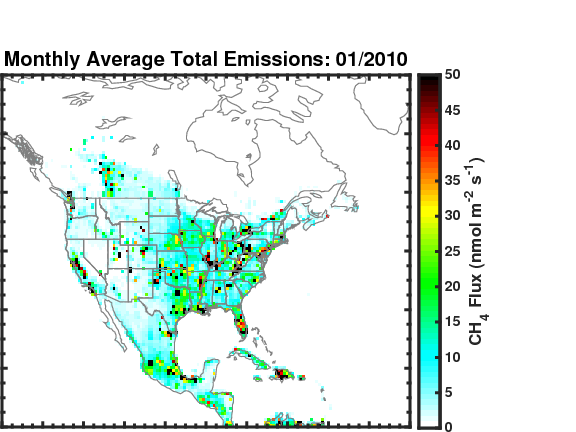
Methane (CH4) Flux for North America L4 Daily V1 (CMS_CH4_FLX_NAD) at GES DISC
National Aeronautics and Space Administration —
The CMS Methane (CH4) Flux for North America data set contains estimates of methane emission in North America based on an inversion of the GEOS-Chem chemical... -
Federal
MASTER: Airborne Science, Nevada, May 2006
National Aeronautics and Space Administration —
This dataset includes Level 1B (L1B) data products from the MODIS/ASTER Airborne Simulator (MASTER) instrument. The spectral data were collected during five flights... -
Federal
LPJ-PROSAIL L2 Global Simulated Dynamic Surface Reflectance V001
National Aeronautics and Space Administration —
LPJ-PROSAIL simulated data products are produced through the coupling of the Lund-Potsdam-Jena dynamic global vegetation model (LPJ) and PROSAIL, a radiative transfer... -
Federal
TES/Aura L2 Peroxyacyl Nitrate Lite Nadir V007
National Aeronautics and Space Administration —
TL2PANLN_7 is the Tropospheric Emission Spectrometer (TES)/Aura Level 2 Atmospheric Temperatures Limb Version 7 data product. It contains atmospheric vertical profile... -
Federal
MODIS/Aqua Surface Reflectance Daily L2G Global 1km and 500m SIN Grid V061
National Aeronautics and Space Administration —
The MYD09GA Version 6.1 product provides an estimate of the surface spectral reflectance of Aqua Moderate Resolution Imaging Spectroradiometer (MODIS) Bands 1 through... -
Federal
Two-dimensional Velocities of Ice Mélange from Jakobshavn Isbræ, Greenland, Version 1
National Aeronautics and Space Administration —
This data set provides velocity components and resolved speeds for the proglacial ice mélange at Jakobshavn Glacier, Greenland. The data were collected using... -
Federal
TES/Aura L2 Carbonyl Sulfide Lite Nadir V007
National Aeronautics and Space Administration —
TL2OCSLN_7 is the Tropospheric Emission Spectrometer (TES)/Aura Level 2 Carbonyl Sulfide Lite Nadir Version 7 data product. TES was an instrument aboard NASA's Aura... -
Federal
z0MGS_Dust Catalog
National Aeronautics and Space Administration —
The z0MGS_Dust project consists of Herschel images from PACS and SPIRE available for 1578 galaxies, dust emission parameters for 819 galaxies, and integrated... -
Federal
Wind 3DP SST Foil Electron Energy-Angle Distributions
National Aeronautics and Space Administration —
Electron energy-angle distributions 27-520 keV, often at 24 sec, SST Foil, Wind 3DP - R. Lin (UC Berkeley) -
Federal
Mediterranean Sea High Resolution SST L4 Analysis 1/16deg Resolution
National Aeronautics and Space Administration —
CNR MED Sea Surface Temperature provides daily gap-free maps (L4) at 0.0625deg. x 0.0625deg. horizontal resolution over the Mediterranean Sea. The data are obtained... -
Federal
Measurements from Mumford Cove, Connecticut
National Aeronautics and Space Administration —
Measurements made in and around Mumford Cove, Connecticut since 2015. -
Federal
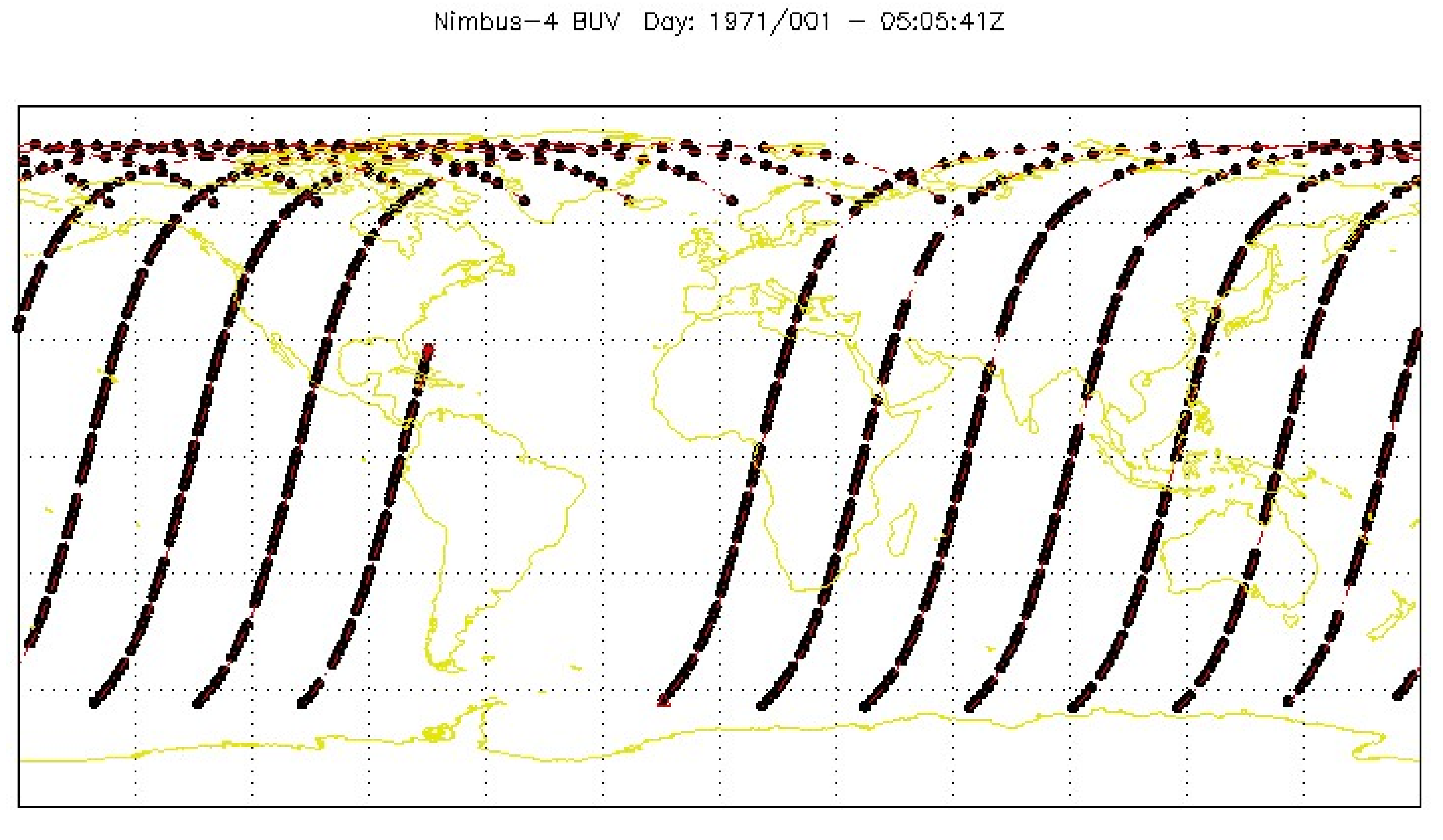
BUV/Nimbus-4 Level 1 Radiance Data V001 (BUVN4L1RUT) at GES DISC
National Aeronautics and Space Administration —
The Nimbus-4 BUV Level-1 Radiance data collection was derived from the Primary Data Base (PDB) product and contains the calibrated and geolocated backscattered...

Official websites use .gov
A
.gov website belongs to an official government
organization in the United States.
Secure .gov websites use HTTPS
A
lock (
) or https:// means you’ve safely connected to
the .gov website. Share sensitive information only on official,
secure websites.