
-
Federal
Aquarius Official Release Level 3 Sea Surface Salinity Standard Mapped Image Daily Data V5.0 recent views
National Aeronautics and Space Administration —
Aquarius Level 3 sea surface salinity (SSS) standard mapped image data contains gridded 1 degree spatial resolution SSS averaged over daily, 7 day, monthly, and... -
Federal
W00224: NOS Hydrographic Survey , Approaches to Choptank River, Maryland, 2011-05-26 recent views
National Oceanic and Atmospheric Administration, Department of Commerce —
The National Oceanic and Atmospheric Administration (NOAA) has the statutory mandate to collect hydrographic data in support of nautical chart compilation for safe... -
Federal
Aquarius Official Release Level 3 Sea Surface Density Standard Mapped Image Mission Cumulative Data V5.0 recent views
National Aeronautics and Space Administration —
Aquarius Level 3 sea surface density standard mapped image data contains gridded 1 degree spatial resolution derived density averaged over daily, 7 day, monthly, and... -
Federal
NIST/NIBIB Medical Imaging Phantom Lending Library recent views
National Institute of Standards and Technology —
This database contains imaging and calibration data for phantoms contained in the NIST/NIBIB Phantom Lending Library (PLL). Description and access to the PLL can be... -
Federal
Aquarius Official Release Level 3 Sea Surface Density Standard Mapped Image Annual Data V5.0 recent views
National Aeronautics and Space Administration —
Aquarius Level 3 sea surface density standard mapped image data contains gridded 1 degree spatial resolution SSS averaged over daily, 7 day, monthly, and seasonal... -
Federal
Delta-X: Soil Properties for Herbaceous Wetlands, MRD, Louisiana, 2021, V3 recent views
National Aeronautics and Space Administration —
This dataset contains properties of soil core samples for herbaceous wetlands collected in the Atchafalaya and Terrebonne basins in southeastern coastal Louisiana for... -
Federal
Global Rural-Urban Mapping Project, Version 1 (GRUMPv1): National Identifier Grid recent views
National Aeronautics and Space Administration —
The Global Rural-Urban Mapping Project, Version 1 (GRUMPv1): National Identifier Grid is derived from the land area grid to create a raster surface where pixels... -
Federal
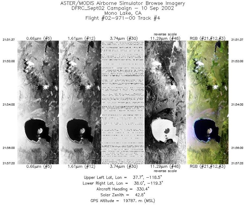
MASTER: Airborne Science, Southwestern US, September, 2002 recent views
National Aeronautics and Space Administration —
This dataset includes Level 1B (L1B) and Level 2 (L2) data products from the MODIS/ASTER Airborne Simulator (MASTER) instrument. The spectral data were collected... -
Federal
RapidScat Level 2B Climate Ocean Wind Vectors in 12.5km Footprints recent views
National Aeronautics and Space Administration —
This dataset contains the RapidScat Level 2B 12.5km Version 1.0 Climate quality ocean surface wind vectors. The Level 2B wind vectors are binned on a 12.5 km Wind... -
Federal
Black Sea High Resolution SST L4 Analysis 0.0625 deg Resolution NGDA recent views
National Aeronautics and Space Administration —
CNR MED Sea Surface Temperature provides daily gap-free maps (L4) at 0.0625 deg. x 0.0625 deg. horizontal resolution over the Black Sea. The data are obtained from... -
Federal
Annual Global High-Resolution Extreme Heat Estimates (GEHE), 1983-2016 recent views
National Aeronautics and Space Administration —
The Annual Global High-Resolution Extreme Heat Estimates (GEHE), 1983-2016 data set provides global 0.05 degrees (~5 km) gridded annual counts of the number of days... -
Federal
SPURS-2 S/V Lady Amber underway Thermosalinograph and Sea Snake data for the E. Tropical Pacific field campaign recent views
National Aeronautics and Space Administration —
The SPURS (Salinity Processes in the Upper Ocean Regional Study) project is a NASA-funded oceanographic process study and associated field program that aim to... -
Federal
F00477: NOS Hydrographic Survey , 2001-10-26 recent views
National Oceanic and Atmospheric Administration, Department of Commerce —
The National Oceanic and Atmospheric Administration (NOAA) has the statutory mandate to collect hydrographic data in support of nautical chart compilation for safe... -
Federal
H13327: NOS Hydrographic Survey , 2019-11-22 recent views
National Oceanic and Atmospheric Administration, Department of Commerce —
The National Oceanic and Atmospheric Administration (NOAA) has the statutory mandate to collect hydrographic data in support of nautical chart compilation for safe... -
Federal
H11896: NOS Hydrographic Survey , Miami to Port Everglades, Florida, 2009-03-12 recent views
National Oceanic and Atmospheric Administration, Department of Commerce —
The National Oceanic and Atmospheric Administration (NOAA) has the statutory mandate to collect hydrographic data in support of nautical chart compilation for safe... -
Federal
SPURS-2 Neutrally buoyant float data for the E. Tropical Pacific field campaign recent views
National Aeronautics and Space Administration —
The SPURS (Salinity Processes in the Upper Ocean Regional Study) project is a NASA-funded oceanographic process study and associated field program that aim to... -
Federal
JPL GRACE and GRACE-FO Mascon Ocean, Ice, and Hydrology Equivalent Water Height Coastal Resolution Improvement (CRI) Filtered Release 06.3 Version 04 recent views
National Aeronautics and Space Administration —
This dataset contains gridded monthly global water storage/height anomalies relative to a time-mean, derived from GRACE and GRACE-FO and processed at JPL using the... -
Federal
RSS SMAP Level 3 Sea Surface Salinity Standard Mapped Image 8-Day Running Mean V4.0 Validated Dataset recent views
National Aeronautics and Space Administration —
The version 4.0 SMAP-SSS level 3, 8-Day running mean gridded product is based on the fourth release of the validated standard mapped sea surface salinity (SSS) data... -
Federal
F00594: NOS Hydrographic Survey , Delaware River, New Jersey and Pennsylvania, 2010-07-26 recent views
National Oceanic and Atmospheric Administration, Department of Commerce —
The National Oceanic and Atmospheric Administration (NOAA) has the statutory mandate to collect hydrographic data in support of nautical chart compilation for safe... -
Federal
Aquarius CAP Level 3 Wind Speed Standard Mapped Image 7-Day Data V5.0 recent views
National Aeronautics and Space Administration —
Version 5.0 Aquarius CAP Level 3 products are the fourth release of the AQUARIUS/SAC-D mapped salinity and wind speed data based on the Combined Active Passive (CAP)...

Official websites use .gov
A
.gov website belongs to an official government
organization in the United States.
Secure .gov websites use HTTPS
A
lock (
) or https:// means you’ve safely connected to
the .gov website. Share sensitive information only on official,
secure websites.
.jpg)
.jpg)