
-
Federal
West Africa Coastal Vulnerability Mapping: Subset of OpenStreetMap (OSM) Roads
National Aeronautics and Space Administration —
The West Africa Coastal Vulnerability Mapping: Subset of OpenStreetMap (OSM) Roads data set includes roads within 200 kilometers of the coast and was extracted from... -
Federal
Public Use Microdata Samples (PUMS)
National Aeronautics and Space Administration —
The Public Use Microdata Samples (PUMS) are computer-accessible files containing records for a sample of housing Units, with information on the characteristics of... -
Federal
Pilot 2006 Environmental Performance Index (EPI)
National Aeronautics and Space Administration —
The Pilot 2006 Environmental Performance Index (EPI) centers on two broad environmental protection objectives: (1) reducing environmental stresses on human health,... -
Federal
Global Human Settlement Layer: Population and Built-Up Estimates, and Degree of Urbanization Settlement Model Grid
National Aeronautics and Space Administration —
The Global Human Settlement Layer: Population and Built-Up Estimates, and Degree of Urbanization Settlement Model Grid data set provides gridded data on human... -
Federal
Yale Center for Earth Observation (YCEO) Surface Urban Heat Islands, Version 4, 2003-2018
National Aeronautics and Space Administration —
The Yale Center for Earth Observation (YCEO) Surface Urban Heat Islands, Version 4, 2003-2018 includes annual, summertime, and wintertime Surface Urban Heat Island... -
Federal
Global One-Eighth Degree Population Base Year and Projection Grids Based on the Shared Socioeconomic Pathways, Revision 01
National Aeronautics and Space Administration —
The Global One-Eighth Degree Population Base Year and Projection Grids Based on the Shared Socioeconomic Pathways, Revision 01, data set consists of global urban,... -
Federal
Latin America and the Caribbean Population Time Series
National Aeronautics and Space Administration —
The Latin America and the Caribbean Population Time Series data set provides total population estimates using spatially consistent and comparable Units for Latin... -
Federal
Low Elevation Coastal Zone (LECZ) Urban-Rural Population and Land Area Estimates, Version 3
National Aeronautics and Space Administration —
The Low Elevation Coastal Zone (LECZ) Urban-Rural Population and Land Area Estimates, Version 3 data set contains land areas with urban, quasi-urban, rural, and total... -
Federal
Gridded Population of the World, Version 4 (GPWv4): Population Density Adjusted to Match 2015 Revision UN WPP Country Totals, Revision 11
National Aeronautics and Space Administration —
The Gridded Population of the World, Version 4 (GPWv4): Population Density Adjusted to Match 2015 Revision of UN WPP Country Totals, Revision 11 consists of estimates... -
Federal
China Dimensions Data Collection: Chinese County-Level Data on Hospitals and Epidemiology Stations, 1950-1985
National Aeronautics and Space Administration —
The China Dimensions Data Collection: Chinese County-Level Data on Hospitals and Epidemiology Stations, 1950-1985 consists of hospital and epidemiological station... -
Federal
Global Rural-Urban Mapping Project, Version 1 (GRUMPv1): National Administrative Boundaries
National Aeronautics and Space Administration —
The Global Rural-Urban Mapping Project, Version 1 (GRUMPv1): National Administrative Boundaries are derived from the land area grid to show the outlines of pixels... -
Federal
West Africa Coastal Vulnerability Mapping: Commercial Crop Production, 2000
National Aeronautics and Space Administration —
The West Africa Coastal Vulnerability Mapping: Commercial Crop Production, 2000 data set includes 5-minute rasters of crop production in metric tons per grid cell for... -
Federal
Archive of Census Related Products (ACRP): 1990 Street Intersections
National Aeronautics and Space Administration —
The 1990 Street Intersections portion of the Archive of Census Related Products (ACRP) contains the latitude and longitude of street intersections for each county in... -
Federal
Global 1-km Downscaled Population Base Year and Projection Grids Based on the Shared Socioeconomic Pathways, Revision 01
National Aeronautics and Space Administration —
The Global 1-km Downscaled Population Base Year and Projection Grids Based on the Shared Socioeconomic Pathways, Revision 01, data set consists of global urban,... -
Federal
West Africa Coastal Vulnerability Mapping: GPW Version 4 Population Density, Preliminary Release 1, 2010
National Aeronautics and Space Administration —
The West Africa Coastal Vulnerability Mapping: GPW Version 4 Population Density, Preliminary Release 1, 2010, represents the number of persons per square kilometer,... -
Federal
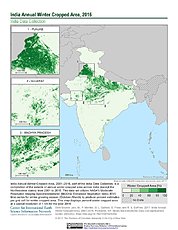
India Annual Winter Cropped Area, 2001-2016 NGDA
National Aeronautics and Space Administration —
The India Annual Winter Cropped Area, 2001 - 2016 consists of annual winter cropped areas for most of India (except the Northeastern states) from 2000-2001 to... -
Federal
Water Security Indicator Model - Global Land Data Assimilation System (WSIM-GLDAS) Monthly Grids, Version 1
National Aeronautics and Space Administration —
The Water Security Indicator Model - Global Land Data Assimilation System (WSIM-GLDAS) Monthly Grids, Version 1 data set identifies and characterizes surpluses and... -
Federal
Millennium Ecosystem Assessment: MA Population
National Aeronautics and Space Administration —
The Millennium Ecosystem Assessment: MA Population provides data and information on baseline population as one of the drivers of ecosystem change. The data was used... -
Federal
Natural Resource Management Index (NRMI), 2010 Release
National Aeronautics and Space Administration —
The Natural Resource Management Index (NRMI), 2010 Release is a composite index for 157 countries derived from the average of four proximity-to-target indicators for...

Official websites use .gov
A
.gov website belongs to an official government
organization in the United States.
Secure .gov websites use HTTPS
A
lock (
) or https:// means you’ve safely connected to
the .gov website. Share sensitive information only on official,
secure websites.