
-
Federal
Land Use and Cover Maps from Landsat, Mawas, Central Kalimantan, Indonesia, 1994-2019
National Aeronautics and Space Administration —
This dataset contains annual land use/cover (LUC) maps at 30 m resolution across Mawas, Central Kalimantan, Indonesia. There are six files, each representing a five-... -
Federal
Spatio-temporal Characteristics of Rainfall in Africa, 0.25 degrees, from 1998-2012
National Aeronautics and Space Administration —
This data set describes rainfall distribution statistics over the African continent, including Madagascar. The rainfall estimates are based on data from the NASA... -
Federal
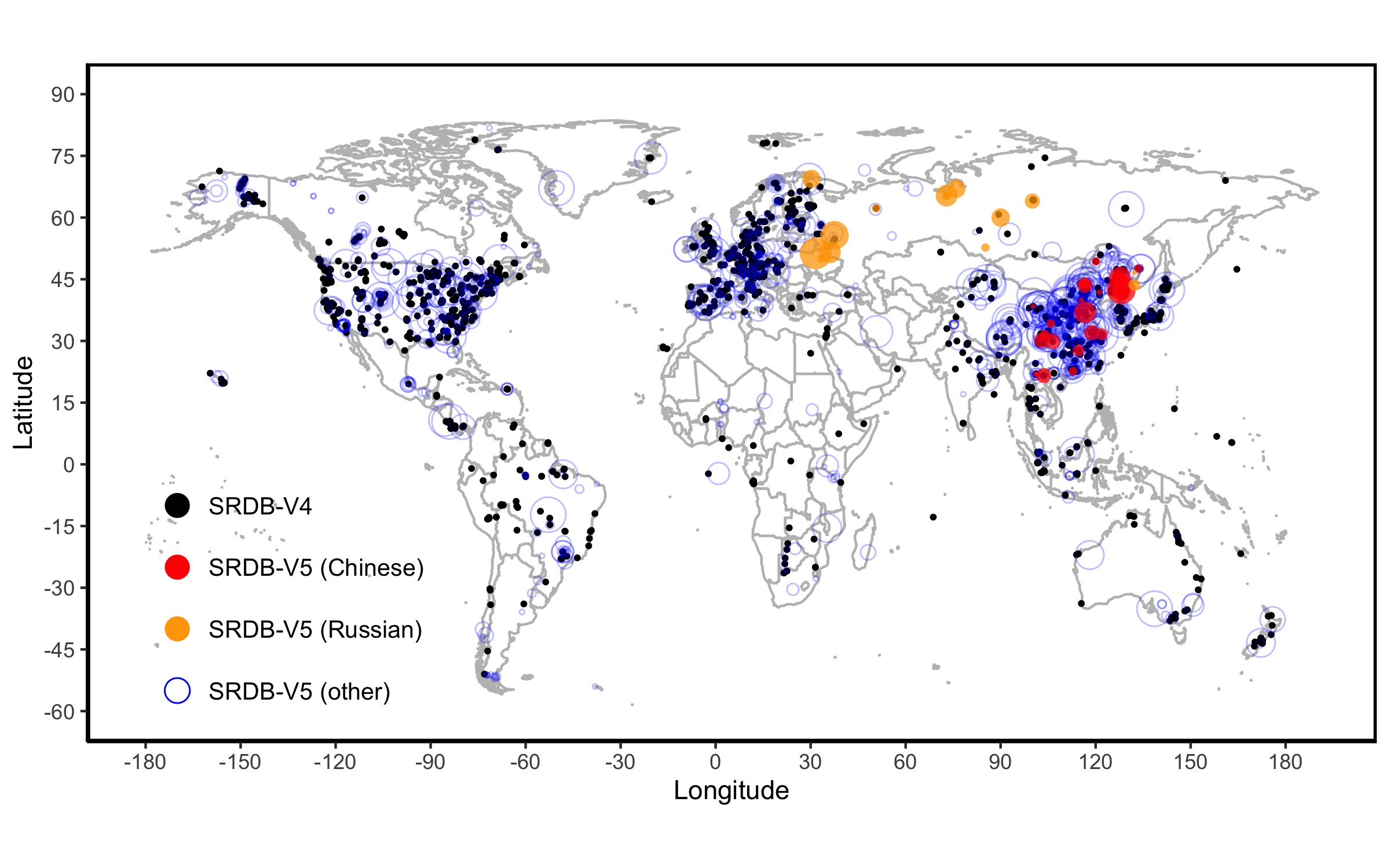
A Global Database of Soil Respiration Data, Version 5.0
National Aeronautics and Space Administration —
The Soil Respiration Database (SRDB) is a near-universal compendium of published soil respiration (Rs) data. The database encompasses published studies that report at... -
Federal
SE-590 Reflectance & Radiances (FIFE)
National Aeronautics and Space Administration —
The SE-590 Reflectance Factors and Radiances Measured from a Helicopter Data Set were collected using the helicopter-borne SE-590 during Intensive Field Campaign 5... -
Federal
LBA-ECO ND-06 Land Use Effects on Soil Nutrients: A Review of Studies 1950-2001
National Aeronautics and Space Administration —
This data set provides measurements of soil properties compiled from 39 studies on nutrient dynamics in natural forests and forest-derived land uses (pasture,... -
Federal
LBA-ECO LC-22 Field Validation of MODIS Deforestation Detection, Brazil, 2005
National Aeronautics and Space Administration —
This data set contains field observations, corresponding GPS points, and point and polygons of deforested areas in the state of Mato Grosso, Brazil, for the period... -
Federal
LBA-ECO LC-03 SAR Images, Land Cover, and Biomass, Four Areas across Brazilian Amazon
National Aeronautics and Space Administration —
This data set provides three related land cover products for four study areas across the Brazilian Amazon: Manaus, Amazonas; Tapajos National Forest, Para Western... -
Federal
LBA-ECO LC-02 Groundwater Levels, Catuaba Experimental Farm, Acre, Brazil: 1999-2004
National Aeronautics and Space Administration —
This data set reports bi-weekly or monthly depth-to-water measurements for three wells located in a ~1,500 ha forest fragment on the Catuaba Experimental Farm, which... -
Federal
LBA-ECO LC-02 Biophysical Measurements of Forests, Acre, Brazil: 1999-2002
National Aeronautics and Space Administration —
This data set provides diameter at breast height (DBH) measurements for 1,063 trees located at the Catuaba Experimental Farm, and 812 trees located in the Humaita... -
Federal
LBA-ECO CD-04 Leaf Litter Data, km 83 Tower Site, Tapajos National Forest, Brazil
National Aeronautics and Space Administration —
Above-ground litter productivity was measured in a 18 ha plot adjacent to the eddy flux tower at the logged forest tower site, km 83, Tapajos National Forest, Para,... -
Federal
LBA-ECO ND-01 Watershed Deforestation from Landsat TM Series, Rondonia, Brazil: 1999
National Aeronautics and Space Administration —
This data set provides estimates of watershed deforestation, as a proportion of the total area of watersheds, in Rondonia, Brazil for 1999. Deforestation maps were... -
Federal
LBA-ECO LC-07 CO2 and CH4 Flux from Wetlands, Negro River Basin, Brazil: 2004-2006
National Aeronautics and Space Administration —
This data set provides estimates of daily and monthly carbon dioxide (CO2) and methane (CH4) diffusive and ebullitive flux for dry and flooded areas from two study... -
Federal
LBA-ECO LC-07 Lake Sediment Nutrient Data, Lago Calado, Brazil: 1982-1984
National Aeronautics and Space Administration —
This data set reports lake sediment texture and porosity, carbon (C), nitrogen (N), and phosphorus (P) content of surficial sediments, 210Pb-derived nutrient... -
Federal
LBA-ECO CD-06 Soil Classification Map, Ji-Parana River Basin, Rondonia, Brazil
National Aeronautics and Space Administration —
This data set provides a digital map of soil orders for the Ji-Parana River Basin, in the state of Rondonia, Brazil (Western Amazonia). Soil orders were manually... -
Federal
ISLSCP II GPPDI, Net Primary Productivity (NPP) Class B Point Data
National Aeronautics and Space Administration —
The Global Primary Production Data Initiative (GPPDI) was set up as a Focus 1 activity of the IGBP Data and Information System, a coordinated international program to... -
Federal
ISLSCP II Global Primary Production Data Initiative Gridded NPP Data
National Aeronautics and Space Administration —
Net Primary Production (NPP) is an important component of the carbon cycle and, among the pools and fluxes that make up the cycle, it is one of the steps that are... -
Federal
Historic Daily Meteorology Data (FIFE)
National Aeronautics and Space Administration —
The FIFE Historic Daily Meteorology Data Data Set is one of the historical data sets used for the FIFE project. The data set contains data back to January, 1900. This... -
Federal
Historic Monthly Meteorology Data (FIFE)
National Aeronautics and Space Administration —
The FIFE Historic Monthly Meteorology Data Data Set is one of the historical data sets used for the FIFE project. This data set provides monthly precipitation values... -
Federal
LBA-ECO ND-02 Soil Gas and Water Content, Rainfall Exclusion, Tapajos National Forest
National Aeronautics and Space Administration —
This data set reports soil carbon dioxide (CO2) and nitrous oxide (N2O) concentrations and soil volumetric water content (VWC) from a rainfall exclusion experiment...

Official websites use .gov
A
.gov website belongs to an official government
organization in the United States.
Secure .gov websites use HTTPS
A
lock (
) or https:// means you’ve safely connected to
the .gov website. Share sensitive information only on official,
secure websites.