
-
Federal
BOREAS TGB-10 Oxidant Flux Data over the SSA
National Aeronautics and Space Administration —
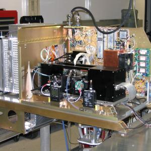
The BOREAS TGB-10 team collected several trace gas data sets in their efforts to determine the role of biogenic hydrocarbon emissions with respect to boreal forest... -
Federal
BOREAS TE-18 Landsat TM Physical Classification Image of the SSA
National Aeronautics and Space Administration —
The objective of this classification is to provide the BOREAS investigators with a data product that characterizes the land cover of the SSA. A Landsat-5 TM image... -
Federal
BOREAS Follow-On HMet-02 Area and Regional Hourly Gridded Met. Data, 1994-1996
National Aeronautics and Space Administration —
Phase II and III gridded data sets have been generated by an objective analysis scheme using all of the surface meteorological station data over BOREAS region for... -
Federal
BOREAS HYD-01 Under Canopy Precipitation Data
National Aeronautics and Space Administration —
Under-canopy precipitation measurements were made by the BOREAS HYD-01 science team in 1994, 1995, and 1996 at various flux tower sites in the NSA and SSA. In 1994,... -
Federal
BOREAS TF-01 SSA-OA Understory Flux, Meteorological, and Soil Temperature Data
National Aeronautics and Space Administration —
The BOREAS TF-01 team collected energy, carbon dioxide, and momentum flux data under the canopy along with meteorological and soils data at the BOREAS SSA-OA site... -
Federal
BOREAS AFM-12 1-km AVHRR Seasonal Land Cover Classification
National Aeronautics and Space Administration —
This regional land cover classification is based on the use of multitemporal 1-km Advanced Very High Resolution Radiometer (AVHRR) National Oceanic and Atmospheric... -
Federal
BOREAS AFM-08 ECMWF Hourly Surface and Upper Air Data for the SSA and NSA
National Aeronautics and Space Administration —
The BOREAS AFM-08 team focused on modeling efforts to improve the understanding of the diurnal evolution of the convective boundary layer over the boreal forest. This... -
Federal
BOREAS HYD-09 Streamflow Data
National Aeronautics and Space Administration —
These streamflow data were collected by the HYD-09 science team to support its research into meltwater supply to the soil during the spring melt period. These data... -
Federal
MMR Ground Data (FIFE)
National Aeronautics and Space Administration —
Surface reflectance factors, radiances, and temperatures were measured with a Mast-borne Modular Multiband Radiometer (MMR), predominantly in the solar principal... -
Federal
LBA-ECO LC-01 SRTM 90-Meter Digital Elevation Model, Northern Ecuadorian Amazon
National Aeronautics and Space Administration —
This data set provides 90-meter resolution Digital Elevation Model data used in the University of North Carolina's Carolina Population Center (CPC) Ecuador Projects.... -
Federal
Integrated Biosphere Simulator Model (IBIS), Version 2.5
National Aeronautics and Space Administration —
The Integrated Biosphere Simulator (or IBIS) is designed to be a comprehensive model of the terrestrial biosphere; the model represents a wide range of processes,... -
Federal
NACP Site: Terrestrial Biosphere Model and Aggregated Flux Data in Standard Format
National Aeronautics and Space Administration —
This data set provides standardized output variables for gross primary productivity (GPP), net ecosystem exchange (NEE), leaf area index (LAI), ecosystem respiration... -
Federal
Pantropical Forest Height and Biomass from GEDI and TanDEM-X Data Fusion
National Aeronautics and Space Administration —
This dataset includes maps of canopy height and aboveground biomass at spatial resolutions of 25 m and 100 m for Mexico, Gabon, French Guiana, and the Amazon Basin.... -
Federal
ATom: L2 In Situ Measurements from Single Particle Soot Photometer (SP2)
National Aeronautics and Space Administration —
This dataset provides the refractory black carbon mass concentration at one-second resolution measured by the Single Particle Soot Photometer (NOAA SP2) instrument... -
Federal
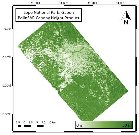
AfriSAR: Rainforest Canopy Height Derived from PolInSAR and Lidar Data, Gabon
National Aeronautics and Space Administration —
This dataset provides estimates of forest canopy height and canopy height uncertainty for study areas in the Pongara National Park and the Lope National Park, Gabon.... -
Federal
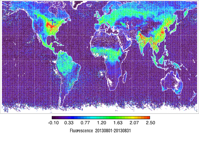
L2 Daily Solar-Induced Fluorescence (SIF) from MetOp-B GOME-2, 2013-2021
National Aeronautics and Space Administration —
This dataset provides Level 2 (L2) Solar-Induced Fluorescence (SIF) of chlorophyll estimates derived from the Global Ozone Monitoring Experiment 2 (GOME-2) instrument...

Official websites use .gov
A
.gov website belongs to an official government
organization in the United States.
Secure .gov websites use HTTPS
A
lock (
) or https:// means you’ve safely connected to
the .gov website. Share sensitive information only on official,
secure websites.