

9,990 datasets found for "pg麻将胡了500一把视频✅澳门葡京赌场官方网站-网址【079.one】㊙️最火爆PG电子超高爆奖率,注册即送38元.qBwZzOKGbIWmjJ"
-
Federal
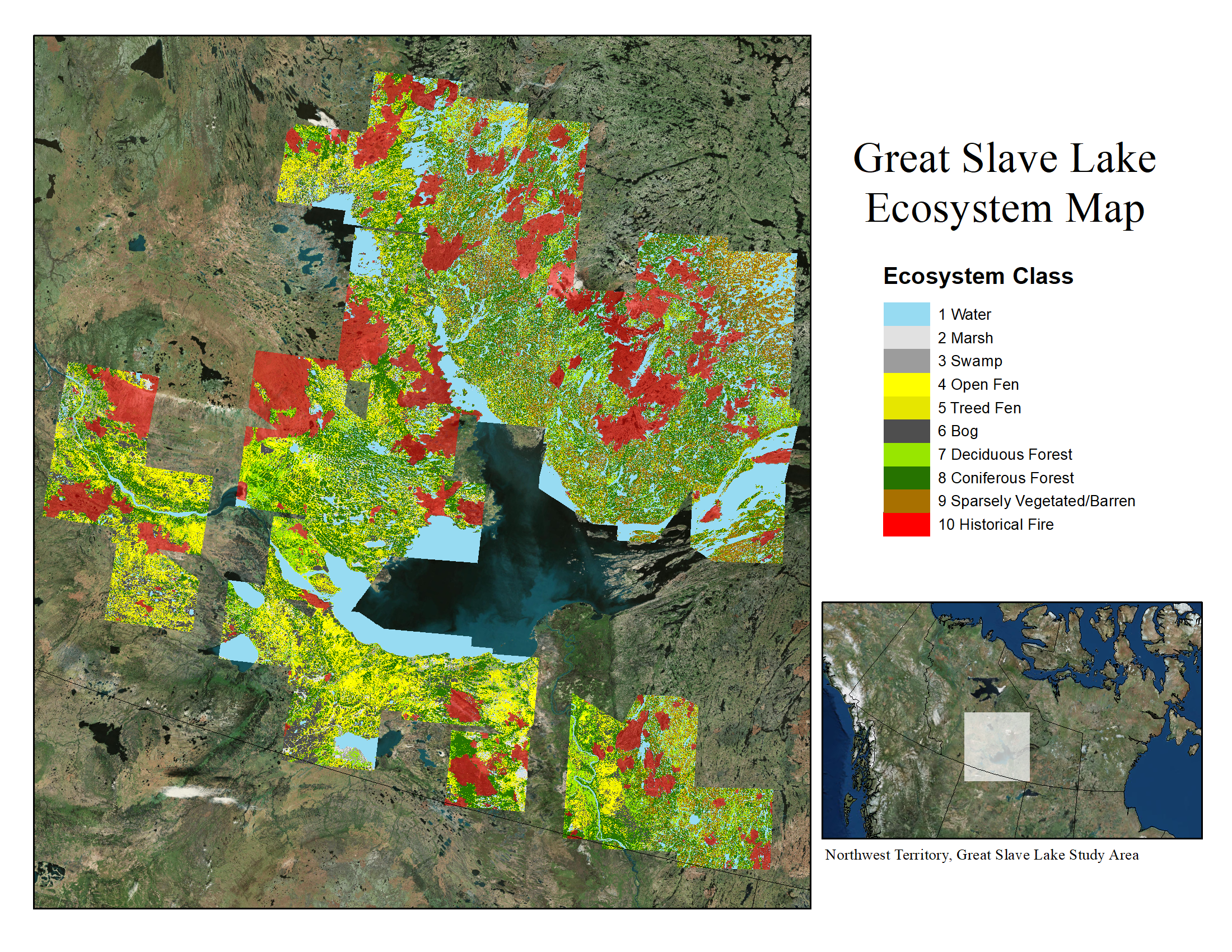
ABoVE: Ecosystem Map, Great Slave Lake Area, Northwest Territories, Canada, 1997-2011
National Aeronautics and Space Administration —
This dataset provides an ecosystem type map at 12.5 meter pixel spacing and 0.2 ha minimum mapping unit for the area surrounding Great Slave Lake, Northwest... -
Federal
ATom: Comprehensive Aerosol Properties, 2016-2018, Version 2
National Aeronautics and Space Administration —
This dataset contains comprehensive measurements of aerosol microphysical, chemical, and optical properties derived for both dry and ambient conditions from in situ... -
Federal
Medicare Post-Acute Care Utilization - Home Health Agency
U.S. Department of Health & Human Services —
The Medicare Post-Acute Care (PAC) Utilization - Home Health Agency (HHA) dataset contains data summarized at the provider, state, and national levels. Payment... -
Federal
Cape Cod National Seashore Long-Term Hydrologic Monitoring Data from CACOHYDRO Project from 1999-2023 as of 2024-08-12
Department of the Interior —
This data package was created 2024-10-18 17:22:23 by NPSTORET and includes selected project, location, and result data. Data contained in the Cape Cod National... -
Federal
Great Smoky Mountains National Park 1991-2023 Noland Divide Water Quality Monitoring Data from the GRSM_ND Project as of 2024-05-10
Department of the Interior —
This data package was created 2024-10-17 16:33:32 by NPSTORET and includes selected project, location, and result data. Data contained in the Great Smoky Mountains... -
Federal
Life history strategies of stream fishes linked to predictors of hydrologic stability
Department of the Interior —
Open Access Data. Hitt, NP, Landsman, AP, and Raesly, RL. 2022. Life history strategies of stream fishes linked to predictors of hydrologic stability. Ecology and... -
Federal
NGPN Plant Community Monitoring for Agate Fossil Beds National Monument (AGFO)
Department of the Interior —
These data were generated by the work of many different field crews (2011-2024) who visited each unit each year collecting information on the condition of selected... -
Federal
Southeast Alaska I&M Network Water Quality Data Package (FQ_Q) for monitoring years 2010-2022 at Glacier Bay National Park and Preserve
Department of the Interior —
This data set is a comma-separated values (CSV) file containing continuous hourly water quality observations of the Salmon River in Glacier Bay National Park and... -
Federal
Water Quality Data starting in 2017 for the Lamar River near Tower Ranger Station, WY
Department of the Interior —
Comma separated values for monthly water chemistry data and water quality field parameters. -
Federal
Estuarine Nutrient Enrichment Tier-3 Seagrass Monitoring Data for Assateague Island National Seashore through 2021 (Certified)
Department of the Interior —
As part of the Northeast Coastal and Barrier Network's Estuarine Nutrient Enrichment Monitoring program, Network staff and cooperators continued to monitor seagrass... -
Federal
BOREAS Agriculture Canada Central Saskatchewan Vector Soils Data, R1
National Aeronautics and Space Administration —
This data set provides soil descriptions for forested areas in the BOREAS southern study area (SSA) in central Saskatchewan, Canada provided by Agriculture Canada.... -
State
i06 Bathy NCRO 20240123 SacramentoRiver
State of California —
This service, (i06_SingleBeam_Bathymetry) is a service containing point feature layers with single beam bathymetric data collected by California Department of Water... -
Federal
ATom: Data Stream for Modeling the Reactivity of ATom Air Parcels, 2016-2018
National Aeronautics and Space Administration —
This dataset provides Modeling Data Stream (MDS) and Reactivity Data Stream (RDS) products for each of the four ATom campaigns conducted from 2016 to 2018. MDS files... -
Federal
Southeast Alaska I&M Network Water Quality Data Package (FQ_Q) for monitoring years 2011-2022 at Klondike Gold Rush National Historical Park
Department of the Interior —
This data set is a comma-separated values (CSV) file containing continuous hourly water quality observations of the Taiya River in Klondike Gold Rush National... -
Federal
BLM Natl WesternUS FIAT Project Planning Areas 2015 Polygon
Department of the Interior —
This data represents a management strategy of the Fire and Invasives Assessment Tool (FIAT). Project Planning Area (PPA) polygons are part of the FIAT Step 2 process.... -
Federal
Boquet River, NY radio telemetry transmitters 2022
Department of the Interior —
Tabular dataset containing information on radio telemetry (Lotek) transmitters surgically implanted within landlocked Atlantic salmon, or deployed as beacon... -
Federal
Oregon Coast NWRC: Surface Nesting Seabirds - Aerial Photographic Colony Surveys - 2009 GIS Raw Count Databases
Department of the Interior —
This reference archives metadata about the collection of geospatial data which may be stored in a variety of file formats (e.g. shapefile, geodatabase) for the Oregon... -
Federal
Kootenai NWR: Invasive Plant Prioritization Workshop (IPIP) - Database
Department of the Interior —
This application and associated database contains data on species reviewed during the Little Pend Oreille NWR Invasive Plant Species Prioritization (IPPT) workshop....
9,990 datasets found for "pg麻将胡了500一把视频✅澳门葡京赌场官方网站-网址【079.one】㊙️最火爆PG电子超高爆奖率,注册即送38元.qBwZzOKGbIWmjJ"