
-
Federal
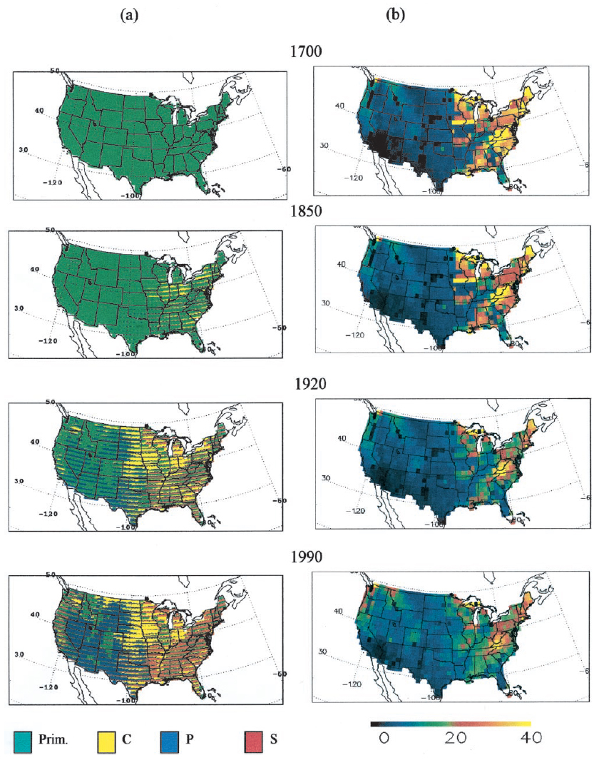
Ecosystem Demography Model: U.S. Ecosystem Carbon Stocks and Fluxes, 1700-1990
National Aeronautics and Space Administration —
This model product contains the source code for the Ecosystem Demography Model (ED version 1.0) as well as model input and output data files for the conterminous... -
Federal
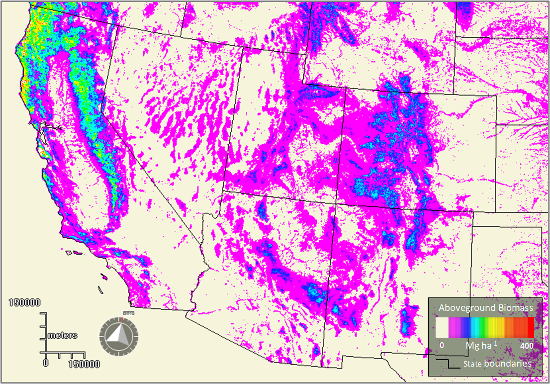
Forest Aboveground Biomass for the Southwestern U.S. from MISR, 2000-2021
National Aeronautics and Space Administration —
This dataset provides estimates of forest aboveground biomass (AGB; in Mg ha-1) at a resolution of 250 m for the southwestern United States over the time period... -
Federal
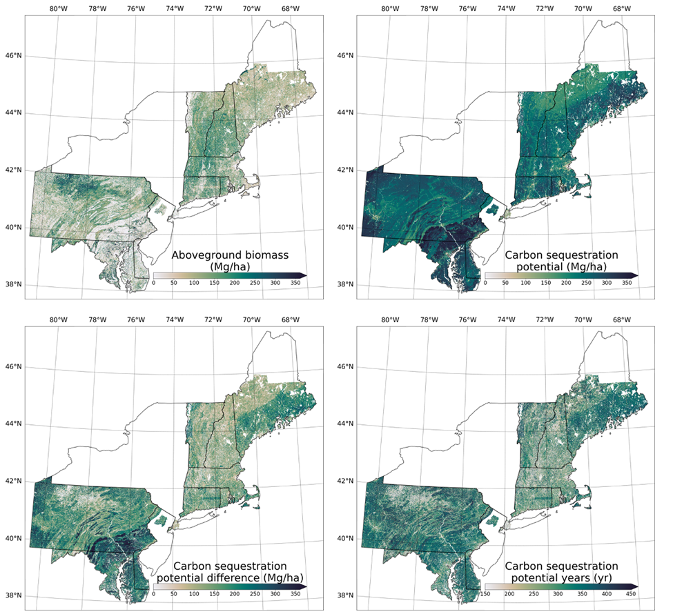
Forest Aboveground Biomass and Carbon Sequestration Potential, Northeastern USA
National Aeronautics and Space Administration —
This dataset provides 90 m estimates of forest aboveground biomass (Mg/ha) for nominal 2011 and projections of carbon sequestration potential for 11 states in the... -
Federal
ECOSTRESS Evaporative Stress Index dis-ALEXI USDA Daily L4 Global 30m V001
National Aeronautics and Space Administration —
The ECOsystem Spaceborne Thermal Radiometer Experiment on Space Station (ECOSTRESS) mission measures the temperature of plants to better understand how much water... -
Federal
GPM GROUND VALIDATION KTLX NEXRAD MC3E V1
National Aeronautics and Space Administration —
The GPM Ground Validation KTLX NEXRAD MC3E dataset was collected from April 22, 2011 to June 6, 2011 for the Midlatitude Continental Convective Clouds Experiment... -
Federal
GPM GROUND VALIDATION KVNX NEXRAD MC3E V1
National Aeronautics and Space Administration —
The GPM Ground Validation KVNX NEXRAD MC3E dataset was collected from April 22, 2011 to June 6, 2011 for the Midlatitude Continental Convective Clouds Experiment... -
Federal
GPM GROUND VALIDATION KINX NEXRAD MC3E V1
National Aeronautics and Space Administration —
The GPM Ground Validation KINX NEXRAD MC3E dataset was collected from April 22, 2011 to June 6, 2011 for the Midlatitude Continental Convective Clouds Experiment... -
Federal
GPM GROUND VALIDATION COMPOSITE SATELLITE OVERPASSES MC3E V1
National Aeronautics and Space Administration —
The GPM Ground Validation Composite Satellite Overpasses MC3E dataset provides satellite overpasses from the AQUA satellite during the Midlatitude Continental... -
Federal
Gross Primary Production Maps of Tidal Wetlands across Conterminous USA, 2000-2019
National Aeronautics and Space Administration —
This dataset provides mapped tidal wetland gross primary production (GPP) estimates (g C/m2/day) derived from multiple wetland types at 250-m resolution across the... -
Federal
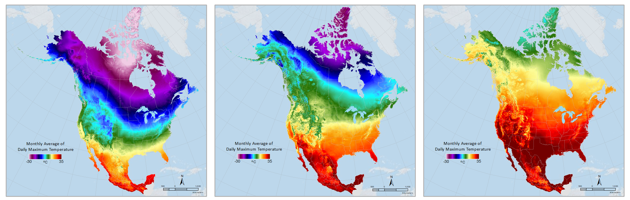
Daymet: Monthly Climate Summaries on a 1-km Grid for North America, Version 4 R1
National Aeronautics and Space Administration —
This dataset provides Daymet Version 4 R1 monthly climate summaries derived from Daymet Version 4 R1 daily data at a 1 km x 1 km spatial resolution for five Daymet... -
Federal
BOREAS RSS-14 GOES-7 Level-1 Visible, Infrared, and Water Vapor Images
National Aeronautics and Space Administration —
The level-1 BOREAS GOES-7 image data were collected by Remote Sensing Science Team 14 (RSS-14) personnel at Florida State University (FSU) and delivered to BORIS. The... -
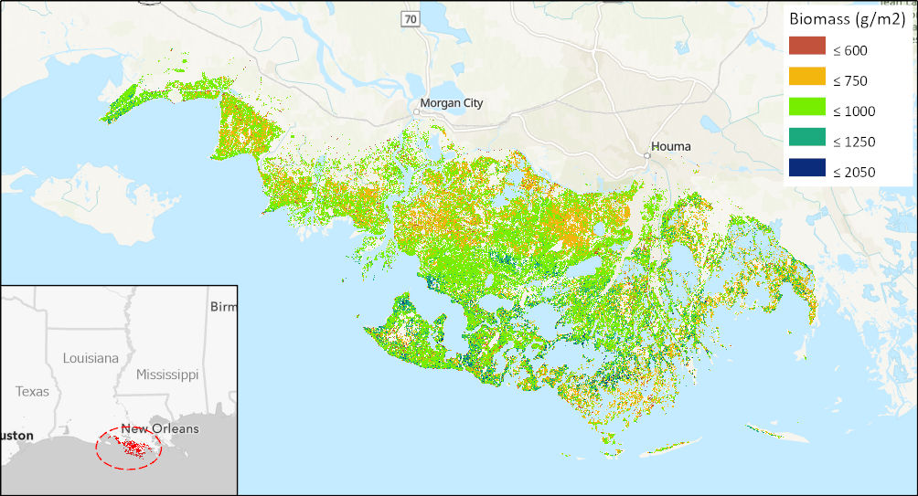
Federal
Aboveground Biomass High-Resolution Maps for Selected US Tidal Marshes, 2015
National Aeronautics and Space Administration —
This dataset provides maps of aboveground tidal marsh biomass (g/m2) at 30 m resolution for six estuarine regions of the conterminous United States: Cape Cod, MA;... -
Federal
BOREAS TF-10 NSA-YJP Tower Flux, Meteorological, and Porometry Data
National Aeronautics and Space Administration —
The BOREAS TF-10 team collected tower flux and meteorological data at two sites, a fen and a young jack pine forest, near Thompson, Manitoba, Canada, as part of... -
Federal
Arctic Vegetation Plots Legacy Project Barter Island and Point Barrow, Alaska, 1994
National Aeronautics and Space Administration —
This dataset provides vegetation cover and environmental plot and soil data collected at two U.S. Air Force sites at Barter Island (BI) and Point Barrow (B), on the... -
Federal
ARISE 2014 C-130 In-Situ Cloud Data
National Aeronautics and Space Administration —
ARISE_Cloud_AircraftInSitu_C130_Data_1 is the Arctic Radiation - IceBridge Sea & Ice Experiment (ARISE) 2014 in-situ cloud data product. This product is a result... -
Federal
BOREAS HYD-04 Standard Snow Course Data
National Aeronautics and Space Administration —
The BOREAS HYD-04 work was focused on collecting data during the winter field campaign (FFC-W) to improve the understanding of winter processes within the boreal... -
Federal
Progression of Ocean Interior Acidification over the Industrial Era from 1800-07-01 to 2014-06-30 (NCEI Accession 0298993)
National Oceanic and Atmospheric Administration, Department of Commerce —
This dataset consists of time-resolved reconstructions of ocean interior acidification from 1800 through 1994, 2004, and 2014. The basis of these reconstructions are... -
Federal
Discrete measurements of dissolved inorganic carbon (DIC), total alkalinity (TA), pH, dissolved oxygen, water temperature, salinity sampled in the National Park Service coastal sites along the Gulf Region and East Coast of the United States from 2024-07-02 to 2024-09-16 (NCEI Accession 0302738)
National Oceanic and Atmospheric Administration, Department of Commerce —
This NCEI Accession consists of discrete measurements of dissolved inorganic carbon (DIC), total alkalinity (TA), pH, dissolved oxygen, water temperature, salinity...

Official websites use .gov
A
.gov website belongs to an official government
organization in the United States.
Secure .gov websites use HTTPS
A
lock (
) or https:// means you’ve safely connected to
the .gov website. Share sensitive information only on official,
secure websites.