

9,810 datasets found for "k98여우알바오피현금알바^✅텔레그램문의superman119※"
-
Federal
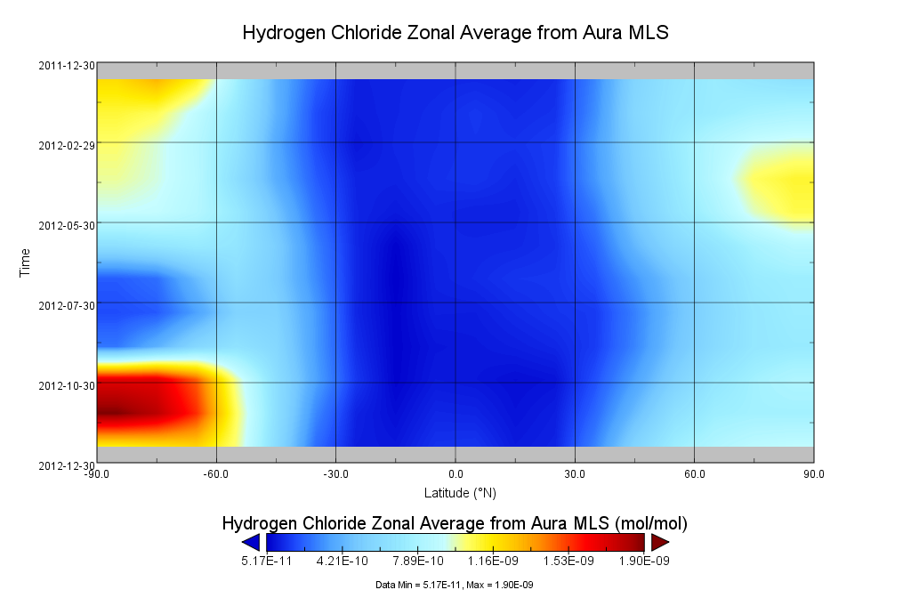
GOZCARDS Source Hydrogen Chloride 1 month L3 10 degree Zonal Means on a Vertical Pressure Grid V1 (GozSmlpHCl) at GES DISC
National Aeronautics and Space Administration —
The GOZCARDS Source Data for Hydrogen Chloride 1 month L3 10 degree Zonal Averages on a Vertical Pressure Grid product (GozSmlpHCl) contains zonal means and related... -
Federal
BOREAS TF-08 NSA-OJP Tower Flux, Meteorological, and Soil Temperature Data
National Aeronautics and Space Administration —
The BOREAS TF-08 team collected energy, CO2, and water vapor flux data at the BOREAS NSA-OJP site during the growing season of 1994 and most of the year for 1996. -
Federal
Bowen Ratio Surface Flux: UNL (FIFE)
National Aeronautics and Space Administration —
The Bowen Ratio Surface Flux Observations (UNL) Data Set contains surface flux and micrometeorolgical measurements collected at one location located in a flat area of... -
Federal
BOREAS TGB-12 Radon-222 Flux Data: NSA
National Aeronautics and Space Administration —
The BOREAS TGB-12 team made measurements of soil carbon inventories, carbon concentration in soil gases, and rates of soil respiration at several sites to estimate... -
Federal
BOREAS RSS-14 GOES-7 Level-1 Visible, Infrared, and Water Vapor Images
National Aeronautics and Space Administration —
The level-1 BOREAS GOES-7 image data were collected by Remote Sensing Science Team 14 (RSS-14) personnel at Florida State University (FSU) and delivered to BORIS. The... -
Federal
BOREAS Level-0 AOCI Imagery: Digital Counts in BIL Format
National Aeronautics and Space Administration —
The level-0 AOCI imagery, along with the other remotely sensed images, was collected to provide spatially extensive information about radiant energy over the primary... -
Federal
BOREAS TE-05 Tree Ring and Carbon Isotope Ratio Data
National Aeronautics and Space Administration —
These data include tree ring widths and cellulose carbon isotope data from coniferous trees collected at the BOREAS NSA and SSA by the BOREAS TE-05 team. Ring width... -
Federal
ARCTAS P-3B Aircraft CAR Data
National Aeronautics and Space Administration —
ARCTAS_AircraftRemoteSensing_P3B_CAR_Data contains remotely sensed data collected via the Cloud Absorption Radiometer (CAR) onboard the P-3B aircraft during the... -
Federal
ABoVE: LVIS L3 Gridded Vegetation Structure across North America, 2017 and 2019
National Aeronautics and Space Administration —
This dataset provides Level 3 (L3) footprint-level gridded metrics and attributes collected from NASA's Land, Vegetation, and Ice Sensor (LVIS)-Facility instrument... -
Federal
ABoVE: Annual Phenology Derived from Landsat across the ABoVE Core Domain, 1984-2014
National Aeronautics and Space Administration —
This dataset provides annual maps of the timing of spring onset with leaf emergence, of autumn onset with leaf senescence, and of peak greenness for each 30 m pixel...
9,810 datasets found for "k98여우알바오피현금알바^✅텔레그램문의superman119※"