
-
Federal
MLS/Aura Level 2 Carbon Monoxide (CO) Mixing Ratio V004 (ML2CO) at GES DISC
National Aeronautics and Space Administration —
ML2CO is the EOS Aura Microwave Limb Sounder (MLS) standard product for carbon monoxide derived from radiances measured by the 640 GHz radiometer. The data version is... -
Federal
MLS/Aura Near-Real-Time L2 Sulfur Dioxide (SO2) Mixing Ratio V005 (ML2SO2_NRT) at GES DISC
National Aeronautics and Space Administration —
ML2SO2_NRT is the EOS Aura Microwave Limb Sounder (MLS) Near-Real-Time (NRT) product for sulfur dioxide (SO2). This product contains SO2 profiles derived from the 190... -
Federal
Long Term Ecological Research Network (LTER)
National Aeronautics and Space Administration —
Measurements from the Long Term Ecological Research Network (LTER) between 1981 and 1999. -
Federal
MODIS Terra Level 3 SST MID-IR Monthly 9km Nighttime V2019.0
National Aeronautics and Space Administration —
Day and night spatially gridded (L3) global NASA skin sea surface temperature (SST) products from the Moderate-resolution Imaging Spectroradiometer (MODIS) onboard... -
Federal
NASA MEASURES Precipitation Ensemble based on TMI TRMM NASA PPS L1C V05 Tbs 1-orbit L2 Swath 5x5km V1 (PRECIP_TMI_TRMM) at GES DISC
National Aeronautics and Space Administration —
The data presented in this level 2 orbital product are rain rate estimates expressed as mm/hour determined from brightness temperatures (Tbs) obtained from the... -
Federal
MLS/Aura Level 3 Daily Binned Chlorine Monoxide (ClO) Mixing Ratio on Assorted Grids V005 (ML3DBCLO) at GES DISC
National Aeronautics and Space Administration —
ML3DBCLO is the EOS Aura Microwave Limb Sounder (MLS) daily binned on various vertical grids product for chlorine monoxide (ClO) derived from radiances measured... -
Federal
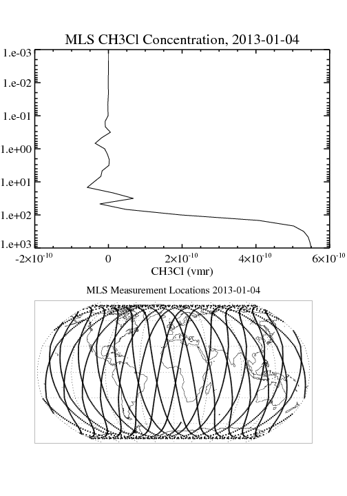
MLS/Aura Level 2 Methyl Chloride (CH3CL) Mixing Ratio V004 (ML2CH3CL) at GES DISC
National Aeronautics and Space Administration —
ML2CH3CL is the EOS Aura Microwave Limb Sounder (MLS) standard product for methyl chloride derived from radiances measured by the 640 GHz radiometer. The data version... -
Federal
MLS/Aura Level 2 Hydrogen Cyanide (HCN) Mixing Ratio V004 (ML2HCN) at GES DISC
National Aeronautics and Space Administration —
ML2HCN is the EOS Aura Microwave Limb Sounder (MLS) standard product for hydrogen cyanide derived from radiances measured primarily by the 190 GHz radiometer. The... -
Federal
MLS/Aura Level 3 Daily Binned Ozone (O3) Mixing Ratio on Assorted Grids V005 (ML3DBO3) at GES DISC
National Aeronautics and Space Administration —
ML3DBO3 is the EOS Aura Microwave Limb Sounder (MLS) daily binned on various vertical grids product for ozone (O3) derived from radiances measured by the 240 GHz... -
Federal
MISR radiometric camera-by-camera Cloud Mask subset for the UAE region V004
National Aeronautics and Space Administration —
UAEMIRCM_004 is the Multi-angle Imaging SpectroRadiometer (MISR) radiometric camera-by-camera Cloud Mask subset for the UAE region version 4. It contains the... -
Federal
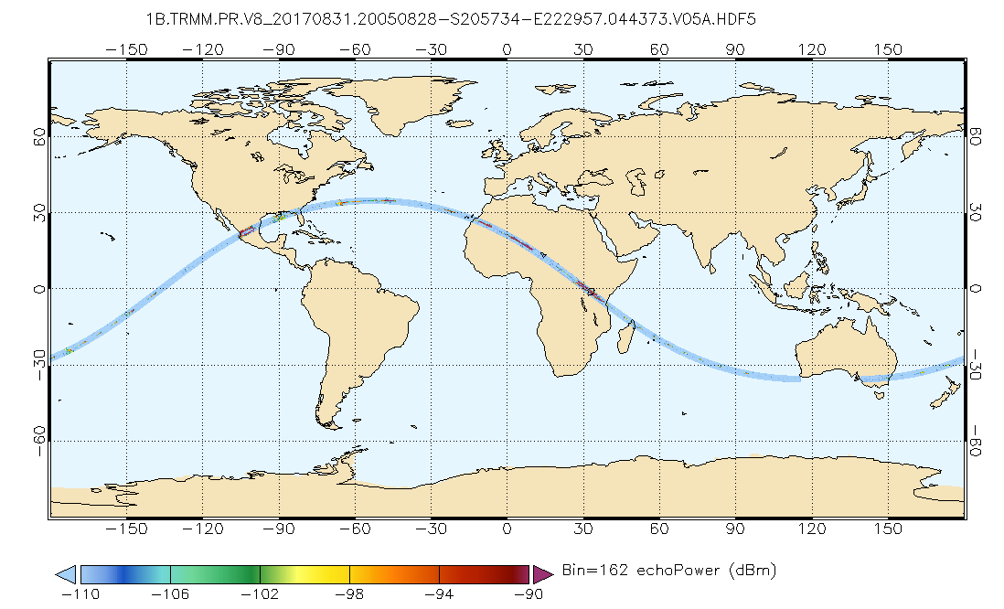
GPM PR on TRMM Echo Power L1B 1.5 hours 5 km V07 (GPM_1BPR) at GES DISC
National Aeronautics and Space Administration —
This is the new (GPM-formated) TRMM product. It replaces the old TRMM_1B21,1C21 Version 07 is the current version of the data set. Previous versions have been... -
Federal
GPM Ground Validation KCAE NEXRAD IPHEx V1
National Aeronautics and Space Administration —
The GPM Ground Validation KCAE NEXRAD IPHEx datasets contain data from the KCAE NEXt Generation Weather RADar system (NEXRAD) instrument in operation during the... -
Federal
BOREAS 1994 HYD-09 Belfort Rain Gauge Data
National Aeronautics and Space Administration —
This data set contains the measurements from the Belfort rain gauges at the BOREAS NSA andSSA. These measurements were submitted in 15-minute and 1-hour intervals.... -
Federal
Aqua MODIS Level-3 Global Binned 4µm Day/Night Sea Surface Temperature (SST4) - Near Real-time (NRT) Data, version R2019.0
National Aeronautics and Space Administration —
The Ocean Biology DAAC produces near real-time (quicklook) products using the best-available combination of ancillary data from meteorological and ozone data. As... -
Federal
Aqua MODIS Level-3 Global Mapped 11µm Daytime Sea Surface Temperature (SST) Data, version R2019.0
National Aeronautics and Space Administration —
MODIS (or Moderate-Resolution Imaging Spectroradiometer) is a key instrument aboard the Terra (EOS AM) and Aqua (EOS PM) satellites. Terra's orbit around the Earth is... -
Federal
AVISO Level 4 Absolute Dynamic Topography for Climate Model Comparison Number of Observations
National Aeronautics and Space Administration —
These data are the numer of observations used to generate the AVISO Level 4 Absolute Dynamic Topography for Climate Model Comparison Number of Observations data set... -
Federal
An International Study of the Marine Biogeochemical Cycles of Trace Elements and Isotopes (GEOTRACES)
National Aeronautics and Space Administration —
Measurements made under the GEOTRACES program of Biogeochemical Cycles of Trace Elements and their Isotopes. -
Federal
Aquarius Official Release Level 3 Sea Surface Density Standard Mapped Image Descending 7-Day Data V5.0
National Aeronautics and Space Administration —
Aquarius Level 3 sea surface density standard mapped image data contains gridded 1 degree spatial resolution density data averaged over daily, 7 day, monthly, and...

Official websites use .gov
A
.gov website belongs to an official government
organization in the United States.
Secure .gov websites use HTTPS
A
lock (
) or https:// means you’ve safely connected to
the .gov website. Share sensitive information only on official,
secure websites.