

930 datasets found for "agriculture"
-
Federal
Eddy Corr. Surface Flux: UNL (FIFE)
National Aeronautics and Space Administration —
Surface flux and micrometeorological measurements were collected at one site within the northwest quadrant near the center of the FIFE study area during all five of... -
Federal
Global Food Security-support Analysis Data (GFSAD) Cropland Extent 2010 North America product 30 m V001
National Aeronautics and Space Administration —
The NASA Making Earth System Data Records for Use in Research Environments (MEaSUREs) Global Food Security-support Analysis Data (GFSAD) data product provides... -
Federal
AfriSAR: Aboveground Biomass for Lope, Mabounie, Mondah, and Rabi Sites, Gabon
National Aeronautics and Space Administration —
This dataset provides gridded estimates of aboveground biomass (AGB) for four sites in Gabon at 0.25 ha (50 m) resolution derived with field measurements and airborne... -
Federal
Annual wildland fire emissions (WFEIS v0.5) for Conterminous US and Alaska, 2001-2013
National Aeronautics and Space Administration —
This data set contains annual modeled estimates of wildland fire emissions at 0.01 degree (~1-km) spatial resolution from the Wildland Fire Emissions Information... -
Federal
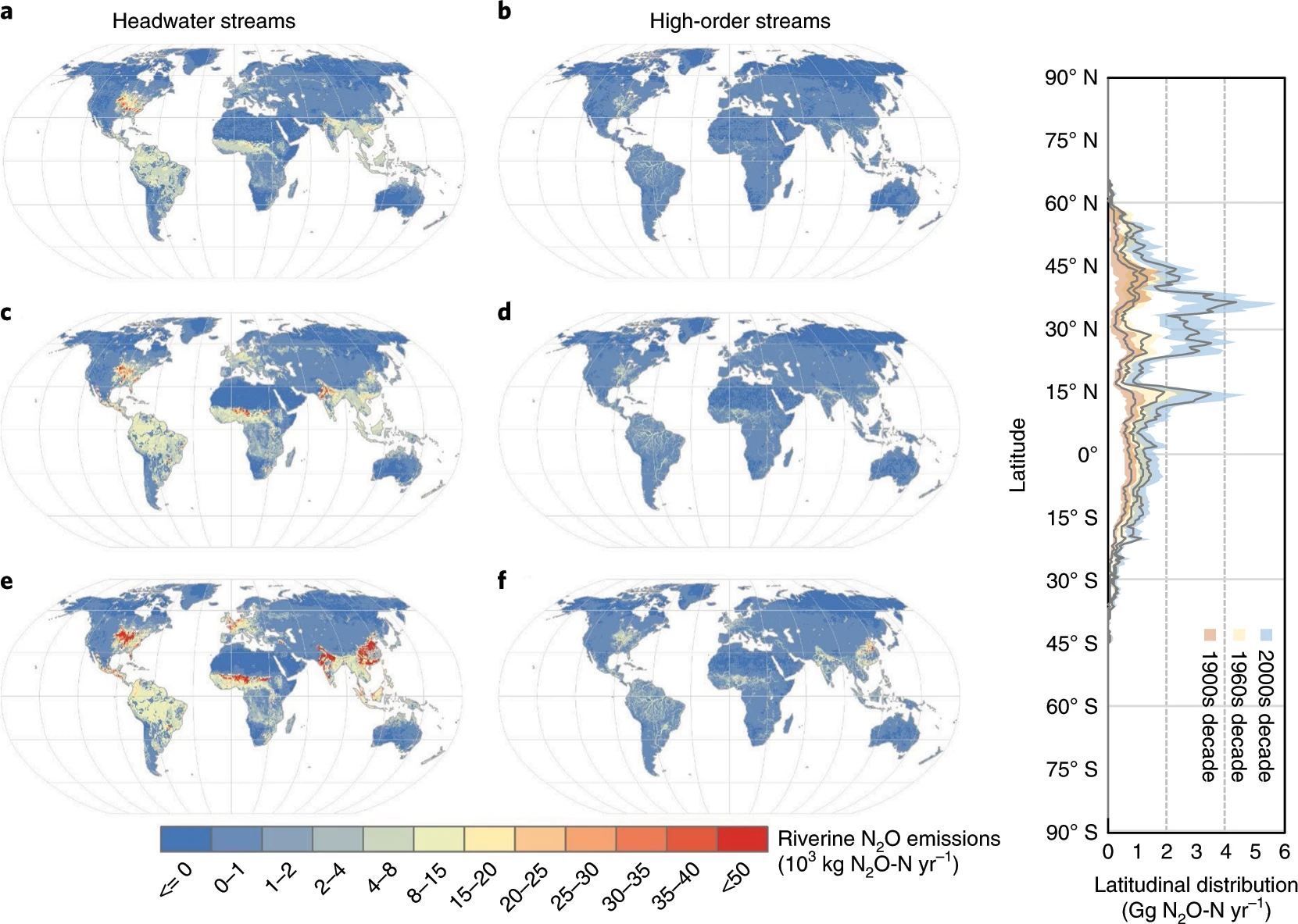
CMS: Annual Estimates of Global Riverine Nitrous Oxide Emissions, 1900-2016
National Aeronautics and Space Administration —
This dataset provides modeled estimates of annual nitrous oxide (N2O) emissions at a coarse geographic scale (0.5 x 0.5 degree) for two sets of global rivers and... -
Federal
BOREAS TGB-07 Ambient Air Herbicide and Organochlorine Concentration Data
National Aeronautics and Space Administration —
The BOREAS TGB-07 team measured the concentration and flux of several agricultural pesticides in air, rainwater, and dry deposition samples in order to determine the... -
Federal
Geospatial data for the Vegetation Mapping Inventory Project of Mojave National Preserve and Castle Mountains National Monument
Department of the Interior —
The files linked to this reference are the geospatial data created as part of the completion of the baseline vegetation inventory project for the NPS park unit.... -
Federal
Geospatial data for the Vegetation Mapping Inventory Project of Padre Island National Seashore
Department of the Interior —
The files linked to this reference are the geospatial data created as part of the completion of the baseline vegetation inventory project for the NPS park unit.... -
Federal
BOREAS Agriculture Canada Central Saskatchewan Vector Soils Data, R1
National Aeronautics and Space Administration —
This data set provides soil descriptions for forested areas in the BOREAS southern study area (SSA) in central Saskatchewan, Canada provided by Agriculture Canada.... -
Federal
Imagery data for the Vegetation Mapping Inventory Project of Lincoln Boyhood National Monument
Department of the Interior —
This reference contains the imagery data used in the completion of the baseline vegetation inventory project for the NPS park unit. Orthophotos, raw imagery, and...
930 datasets found for "agriculture"