
-
Federal
DISCOVER-AQ Colorado Deployment P-3B Aircraft Merged Data Files
National Aeronautics and Space Administration —
DISCOVERAQ_Colorado_Merge_Data contains pre-generated merged data files created from measurements obtained onboard the P-3B aircraft during the Colorado (Denver)... -
Federal
ACOS GOSAT/TANSO-FTS Level 2 bias-corrected XCO2 and other select fields from the full-physics retrieval aggregated as daily files V9r (ACOS_L2_Lite_FP) at GES DISC
National Aeronautics and Space Administration —
Version 9r is the current version of the data set. Older versions will no longer be available and are superseded by Version 9r. The ACOS Lite files contain bias-... -
Federal
ABoVE: Passive Microwave-derived Annual Snowpack Main Melt Onset Date Maps, 1988-2023
National Aeronautics and Space Administration —
This dataset provides the annual date of snowpack seasonal beginning melt (i.e., main melt onset date, MMOD) across northwest Canada, Alaska, US, and parts of far... -
Federal
RSS SMAP Level 3 Sea Surface Salinity Standard Mapped Image Monthly V6.0 Validated Dataset
National Aeronautics and Space Administration —
The RSS SMAP Level 3 Sea Surface Salinity Standard Mapped Image Monthly V6.0 Validated Dataset produced by the Remote Sensing Systems (RSS) and sponsored by the NASA... -
Federal
Aeolus CalVal Meteorological and Navigational
National Aeronautics and Space Administration —
Aeolus-CalVal-MetNav_DC8_1 is the Aeolus CalVal Meteorological and Navigational data product. Data was collected using the Global Positioning System (GPS) instrument... -
Federal
Anthropogenic Carbon Emission System, 2012-2017, Version 2
National Aeronautics and Space Administration —
This dataset provides estimates of hourly carbon dioxide (CO2) emissions from the combustion of fossil fuels at 1-km resolution for the coterminous United States... -
Federal
GPM GROUND VALIDATION TWO-DIMENSIONAL VIDEO DISDROMETER (2DVD) NSSTC V1
National Aeronautics and Space Administration —
The GPM Ground Validation Two-Dimensional Video Disdrometer (2DVD) NSSTC dataset was collected by the Two-Dimensional Video Disdrometer (2DVD), which uses two high... -
Federal
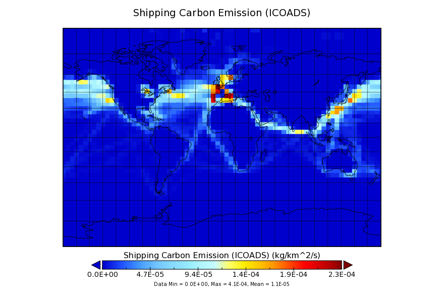
Carbon Monitoring System Flux for Shipping, Aviation, and Chemical Sources L4 V1 (CMSFluxMISC) at GES DISC
National Aeronautics and Space Administration —
This dataset provides the Carbon Flux for Shipping, Aviation, and Chemical Sources. The NASA Carbon Monitoring System (CMS) is designed to make significant... -
Federal
LISTOS Yale Coastal Ground Site Data
National Aeronautics and Space Administration —
LISTOS_Ground_YaleCoastal_Data is the Long Island Sound Tropospheric Ozone Study (LISTOS) ground site data collected at the Yale Coastal ground site during the LISTOS... -
Federal
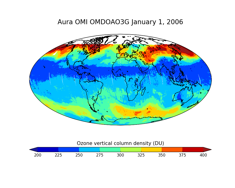
OMI/Aura Ozone (O3) DOAS Total Column Daily L2 Global Gridded 0.25 degree x 0.25 degree V3 (OMDOAO3G) at GES DISC
National Aeronautics and Space Administration —
This Level-2G daily global gridded product OMDOAO3G is based on the pixel level OMI Level-2 DOAO3 product OMDOAO3. This Level-2G global total column ozone product is... -
Federal
Suomi-NPP VIIRS Level-3 Global Binned Triple-window Sea Surface Temperature (SST3) - Near Real-time (NRT) Data, version R2016.2
National Aeronautics and Space Administration —
The Ocean Biology DAAC produces near real-time (quicklook) products using the best-available combination of ancillary data from meteorological and ozone data. As... -
Federal
NCAR Particle Probes IMPACTS
National Aeronautics and Space Administration —
The NCAR Particle Probes IMPACTS dataset consists of data collected from six instruments on the NASA P-3 aircraft, the SPEC Hawkeye Cloud Particle Imager (CPI), the... -
Federal
BOREAS TE-10 Photosynthetic Response Data
National Aeronautics and Space Administration —
The BOREAS TE-10 team collected several data sets in support of its efforts to characterize and interpret information on the gas exchange, reflectance, transmittance,... -
Federal
MiCASA Monthly NPP Rh ATMC NEE FIRE FUEL Fluxes 0.1 degree x 0.1 degree
National Aeronautics and Space Administration —
MiCASA is an extensive revision of CASA-GFED3. CASA-GFED3 derives from Potter et al. (1993), diverging in development since Randerson et al. (1996). CASA is a light... -
Federal
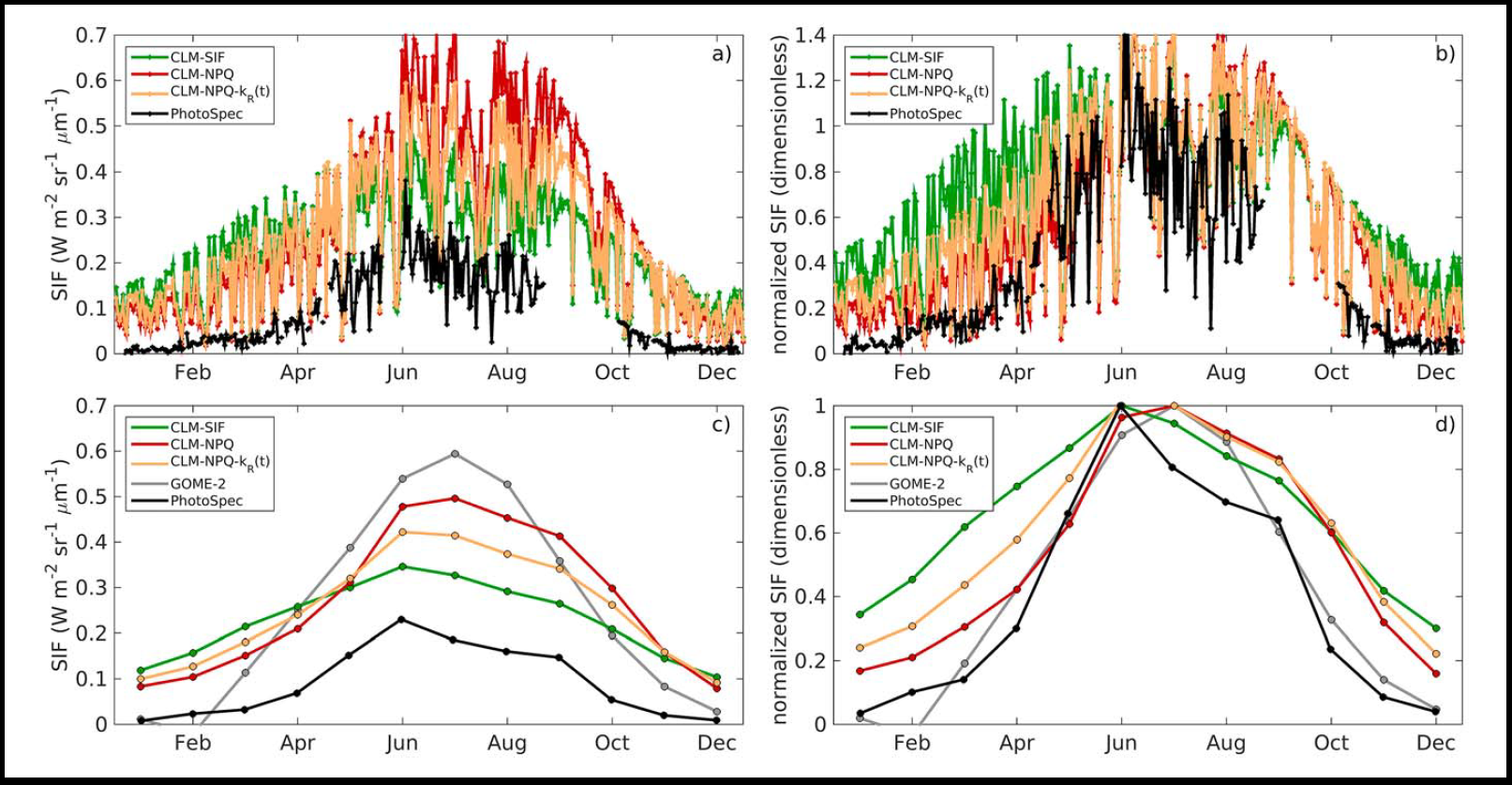
CLM Simulated Solar-Induced Fluorescence, Niwot Ridge, Colorado, USA, 1998-2018
National Aeronautics and Space Administration —
This dataset provides results for simulations of solar-induced chlorophyll fluorescence (SIF) implemented within the terrestrial biosphere Community Land Model (CLM... -
Federal
GPM GROUND VALIDATION NEXRAD LEVEL II KDMX IFLOODS
National Aeronautics and Space Administration —
The GPM Ground Validation Next Generation Weather Radar (NEXRAD) Level II IFloodS datasets were collected from four sites (see Table 1) from March 29, 2013 to June... -
Federal
Global Navigation Satellite System (GNSS) IGS Daily Ionosphere Vertical Total Electron Content (VTEC) Grid Fluctuation Product from NASA CDDIS
National Aeronautics and Space Administration —
This derived product set consists of Global Navigation Satellite System a Ionosphere Vertical Total Electron Content (VTEC) fluctuation measurement product (daily... -
Federal
RLC Forest Fire Images in Russia, 1998-1999
National Aeronautics and Space Administration —
This data set is made up of images of forest fires in Russia from NOAA's Operational Significant Event Imagery (OSEI) archive (http://www.osei.noaa.gov) for the 1998... -
Federal
AMS (Automated Met Station) Data (FIFE)
National Aeronautics and Space Administration —
As part of the FIFE staff science data collection effort, the FIFE Information System (FIS) processed and archived 5 minute, near-surface radiometric and... -
Federal
Aquarius Official Release Level 3 Sea Surface Spiciness Standard Mapped Image Descending Monthly Data V5.0
National Aeronautics and Space Administration —
Aquarius Level 3 sea surface spiciness standard mapped image data contains gridded 1 degree spatial resolution spice data averaged over daily, 7 day, monthly, and...

Official websites use .gov
A
.gov website belongs to an official government
organization in the United States.
Secure .gov websites use HTTPS
A
lock (
) or https:// means you’ve safely connected to
the .gov website. Share sensitive information only on official,
secure websites.