
-
Federal
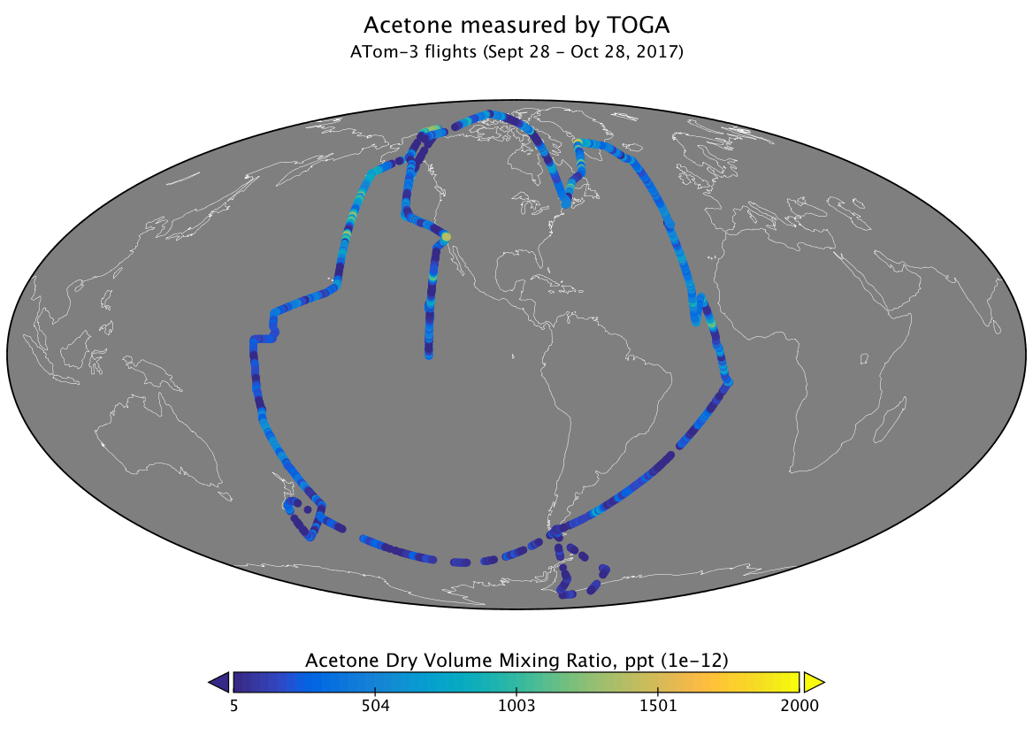
ATom: Volatile Organic Compounds (VOCs) from the TOGA instrument, Version 2
National Aeronautics and Space Administration —
This dataset provides concentrations of volatile organic compounds (VOCs) measured by the Trace Organic Gas Analyzer (TOGA) during the four ATom campaigns. These data... -
Federal
ACTIVATE FLEXible PARTicle (FLEXPART) Dispersion Model Back-trajectories
National Aeronautics and Space Administration —
ACTIVATE-FLEXPART is the FLEXible PARTicle dispersion model back-trajectories ending at the HU-25 Falcon locations. ACTIVATE was a 5-year NASA Earth-Venture Sub-... -
Federal
GHRSST Level 3C North Atlantic Regional (NAR) subskin Sea Surface Temperature from Metop/AVHRR (GDS V2) produced by OSI SAF
National Aeronautics and Space Administration —
A Group for High Resolution Sea Surface Temperature (GHRSST) dataset for the North Atlantic Region (NAR) derived from the Advanced Very High Resolution Radiometer... -
Federal
Delta-X: Matlab Model for Wax Lake Delta Land Accretion
National Aeronautics and Space Administration —
This dataset provides the Matlab sediment transport and land accretion model at Wax Lake Delta (WLD), Atchafalaya Basin, in coastal Louisiana. The data include the... -
Federal
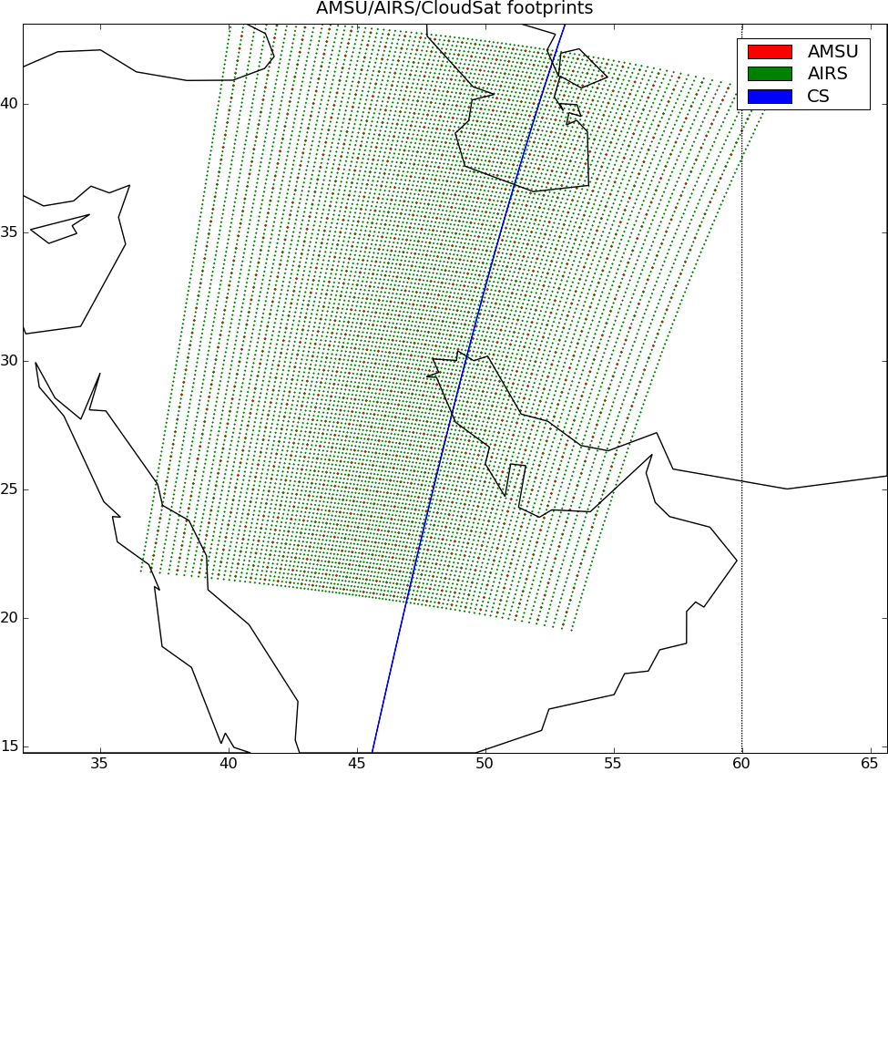
AIRS-CloudSat cloud mask, radar reflectivities, and cloud classification matchups V3.2 (AIRS_CPR_MAT) at GES DISC
National Aeronautics and Space Administration —
This is AIRS-CloudSat collocated subset, in NetCDF-4 format. These data contain collocated: AIRS Level 1b radiances spectra, CloudSat radar reflectivities, and MODIS... -
Federal
ACT-America: CPL-derived Atmospheric Boundary Layer Top Height, Eastern US, 2016-2018
National Aeronautics and Space Administration —
This dataset consists of the atmospheric boundary layer (ABL) top heights and the altitudes of the two additional aerosol layers (in km above mean sea level) derived... -
Federal
Borehole temperatures from mountain permafrost monitoring, Mongolia, Version 1
National Aeronautics and Space Administration —
Location and description of some geocryological boreholes in Mongolia. Data include latitude, longitude, location, depth of permafrost top and bottom, and mean annual... -
Federal
Ocean LiDAR measurements Pacific Ocean
National Aeronautics and Space Administration —
Measurements made in the Tropical Western Pacific Ocean between 1994 and 2001. -
Federal
SMEX02 Tower-Based Radiometric Surface Temperature, Walnut Creek, Iowa, Version 1
National Aeronautics and Space Administration —
This data set includes air temperature, vapor pressure, wind speed, and brightness temperatures taken at 12 flux towers as part of the Soil Moisture Experiment 2002... -
Federal
PEM West B DC-8 In-Situ Trace Gas Data
National Aeronautics and Space Administration —
PEM-West-B_TraceGas_AircraftInSitu_DC8_Data is the in-situ trace gas data collected onboard the DC-8 aircraft during the Pacific Exploratory Mission (PEM) West B... -
Federal
SENTINEL-1B_METADATA_OCN
National Aeronautics and Space Administration —
Sentinel-1B Metadata for OCN product -
Federal
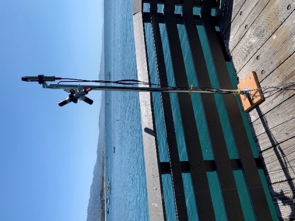
SHIFT: Ramses Trios Radiometer Above Water Measurements, Santa Barbara Sea, CA
National Aeronautics and Space Administration —
This dataset provides calculated remote sensing reflectance (Rrs) from measurements collected with a Ramses TriOS radiometer deployed on the Santa Barbara Museum of... -
Federal
KAKQ NEXRAD IMPACTS V1
National Aeronautics and Space Administration —
The KAKQ NEXRAD IMPACTS dataset consists of Next Generation Weather Radar (NEXRAD) Level II surveillance data that were collected from January 1 to March 1, 2020... -
Federal
SMEX03 Land Use Classification Data: Oklahoma, Version 1
National Aeronautics and Space Administration —
This data set consists of land use classification data derived from Landsat 5 data for the Soil Moisture Experiment 2003 (SMEX03). -
Federal
GPM Ground Validation KMRX NEXRAD IPHEx V1
National Aeronautics and Space Administration —
The GPM Ground Validation KMRX NEXRAD IPHEx dataset contain data from the KMRX NEXt Generation Weather RADar system (NEXRAD) instrument in operation during the... -
Federal
BASIN TCP Stable Isotope Composition of CO2 in Terrestrial Ecosystems
National Aeronautics and Space Administration —
This data set reports stable isotope ratio data of CO2 (13C/12C and 18O/16O) associated with photosynthetic and respiratory exchanges across the biosphere-atmosphere... -
Federal
Sentinel-3A OLCI Level-1B Earth-observation Full Resolution (EFR) Data, version 1
National Aeronautics and Space Administration —
The Ocean and Land Colour Instrument (OLCI) is the successor to ENVISAT's Medium Resolution Imaging Spectrometer (MERIS) having additional spectral channels,... -
Federal
Site Averaged Flux Data: 1987-1989 (Betts)
National Aeronautics and Space Administration —
The Site Averaged Flux Data: 1987 (Betts) Data Set contains the site averaged product data collected by many PIs during the 1987-1989 FIFE experiment. Data are in 30... -
Federal
Daymet: Station-Level Inputs and Cross-Validation for North America, Version 4 R1
National Aeronautics and Space Administration —
This dataset reports the station-level daily weather observation data and the corresponding cross-validation results for three Daymet model parameters: minimum... -
Federal
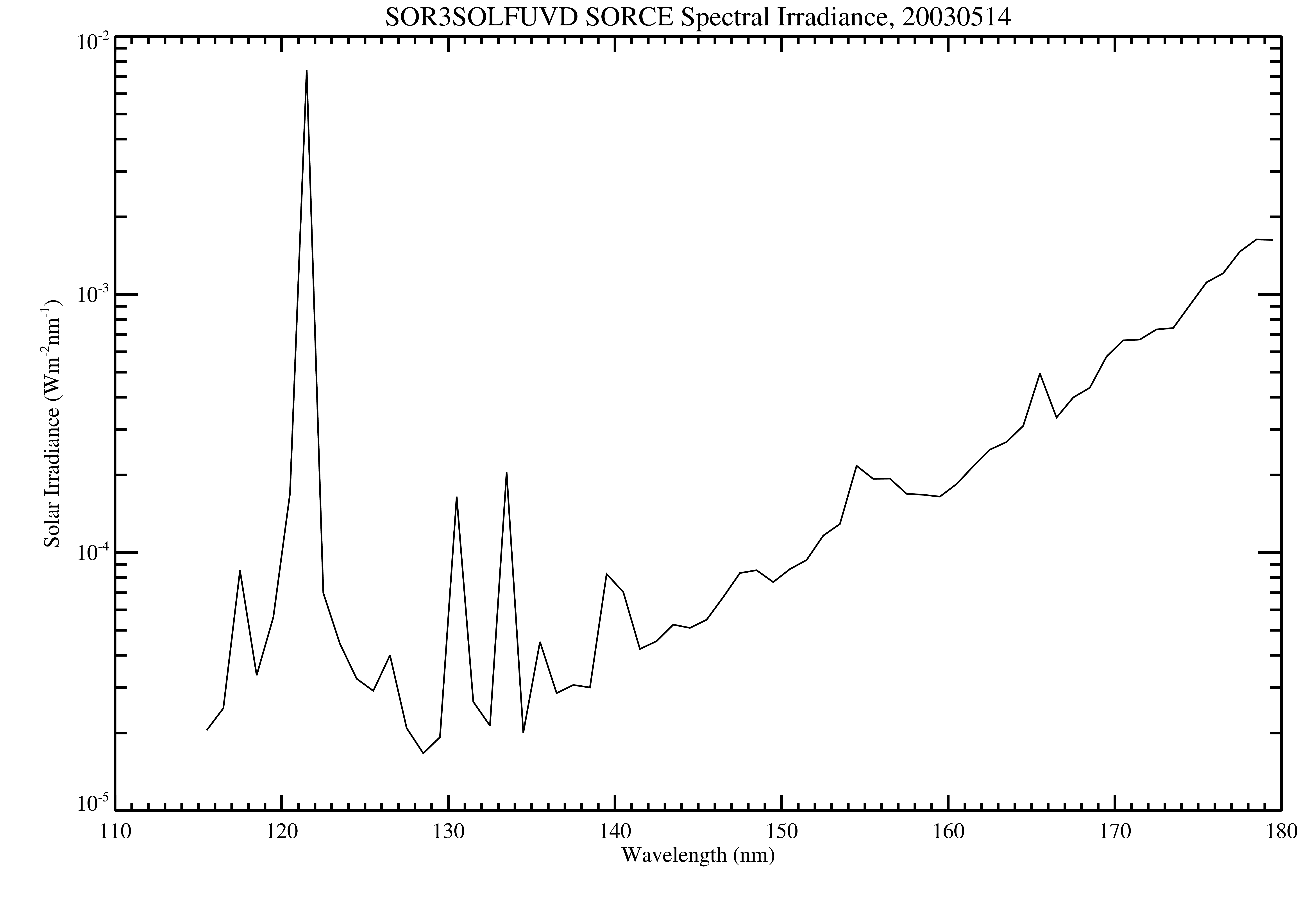
SORCE SOLSTICE FUV Level 3 Solar Spectral Irradiance Daily Means V018 (SOR3SOLFUVD) at GES DISC
National Aeronautics and Space Administration —
Version 018 is the final version of this data product, and supersedes all previous versions. The SORCE SOLSTICE Far-UV Solar Spectral Irradiance (SSI) data product...

Official websites use .gov
A
.gov website belongs to an official government
organization in the United States.
Secure .gov websites use HTTPS
A
lock (
) or https:// means you’ve safely connected to
the .gov website. Share sensitive information only on official,
secure websites.