
-
Federal
Sounder SIPS: AQUA AIRS IR-only Level 3 CLIMCAPS: Comprehensive Quality Control Gridded Monthly V2 (SNDRAQIL3CMCCP) at GES DISC
National Aeronautics and Space Administration —
WARNING: To users of the derived product “co_mmr_midtrop” (carbon monoxide mass mixing ratio to dry air [kg/kg] at ~500 hPa). This variable has a significant bias due... -
Federal
MODIS/Terra Net Evapotranspiration 8-Day L4 Global 500m SIN Grid V006
National Aeronautics and Space Administration —
The MOD16A2 Version 6 data product was decommissioned on July 31, 2023. Users are encouraged to use the MOD16A2... -
Federal
Aquarius Official Release Level 3 Sea Surface Salinity Standard Mapped Image Ascending 7-Day Data V5.0
National Aeronautics and Space Administration —
Aquarius Level 3 sea surface salinity (SSS) standard mapped image data contains gridded 1 degree spatial resolution SSS averaged over daily, 7 day, monthly, and... -
Federal
Aquarius Official Release Level 3 Rain-flagged Sea Surface Salinity Standard Mapped Image Ascending Monthly Data V5.0
National Aeronautics and Space Administration —
Aquarius Level 3 sea surface salinity (SSS) rain-flagged standard mapped image data contains gridded 1 degree spatial resolution SSS averaged over daily, 7 day,... -
Federal
Distribution of Estimated Stand Age Across Siberian Larch Forests, 1989-2012
National Aeronautics and Space Administration —
This data set provides mapped estimates of the stand age of young (less than 25 years old) larch forests across Siberia from 1989-2012 at 30-m resolution. The age... -
Federal
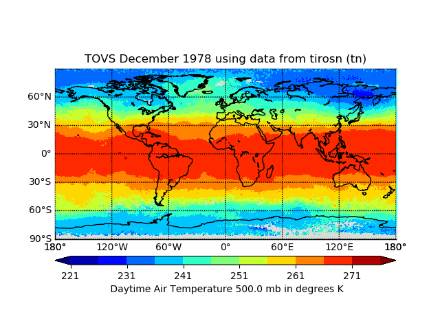
TOVS GLA MONTHLY GRIDS from TIROS-N 02 (TOVSAMTN) at GES DISC
National Aeronautics and Space Administration —
This dataset (TOVSAMTN) contains the TIROS Operational Vertical Sounder (TOVS) level 3 geophysical parameters derived using data from TIROS-N and the physical... -
Federal
GPM Ground Validation USDA ARS Soil Moisture IFloodS V1
National Aeronautics and Space Administration —
The GPM Ground Validation United States Department of Agriculture (USDA) Agricultural Research Service (ARS) Soil Moisture IFloodS dataset was collected during the... -
Federal
GPM GROUND VALIDATION IOWA X-BAND POLARIMETRIC MOBILE DOPPLER WEATHER RADARS IFLOODS V1
National Aeronautics and Space Administration —
The GPM Ground Validation Iowa X-band Polarimetric Mobile Doppler Weather Radars IFloodS dataset was gathered during the IFloodS campaign from April to June 2013... -
Federal
MODIS/Terra Near Real Time (NRT) Geolocation Fields 5-Min L1A Swath 1km
National Aeronautics and Space Administration —
The Near Real Time (NRT) geolocation fields are calculated for each 1 km MODIS Instantaneous Field of Views (IFOV) for all orbits daily. The locations and ancillary... -
Federal
SASS (Subsonics Assessment) Ozone and NOx Experiment (SONEX) Supplementary Data
National Aeronautics and Space Administration —
SONEX_Other_Data_1 is the supplementary datasets for the SONEx suborbital campaign. Included in this product are images from the National Lightning Data Network... -
Federal
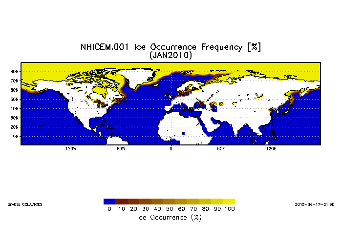
Northern Hemisphere Ice Cover Monthly Statistics at 1 Degree Resolution V001 (NHICEM) at GES DISC
National Aeronautics and Space Administration —
This product is monthly Ice Cover Statistics. The dataset was prepared by Dr. Peter Romanov at Cooperative Institute for Climate Studies(CICS) of the University of... -
Federal
MODIS/Aqua Cloud Mask and Spectral Test Results 5-Min L2 Swath 250m and 1km
National Aeronautics and Space Administration —
The MODIS/Aqua Cloud Mask and Spectral Test Results 5-Min L2 Swath 250m and 1km product consists of global cloud mask quality assurance and other ancillary... -
Federal
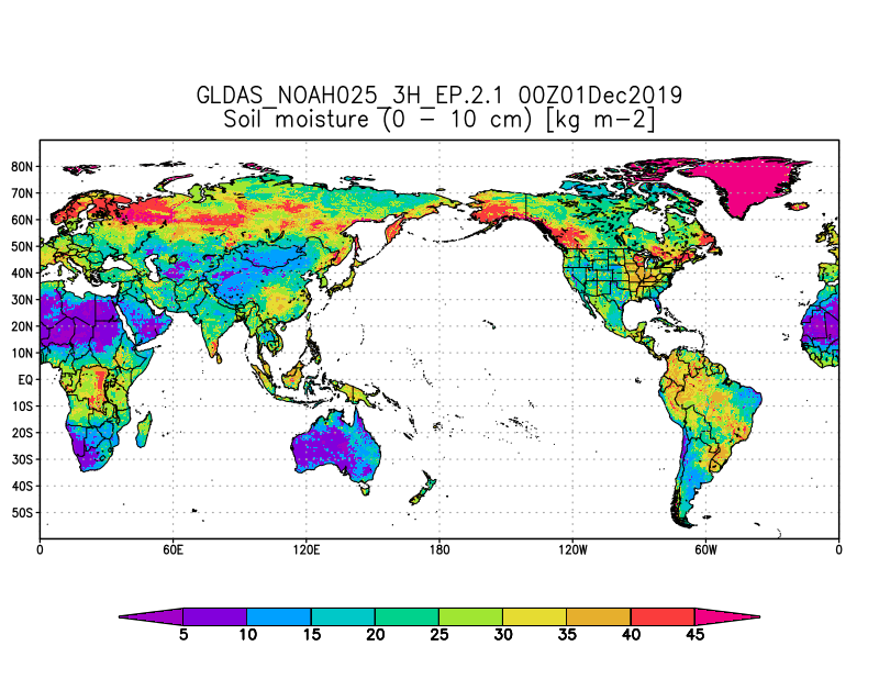
GLDAS Noah Land Surface Model L4 3 hourly 0.25 x 0.25 degree Early Product V2.1 (GLDAS_NOAH025_3H_EP) at GES DISC
National Aeronautics and Space Administration —
NASA Global Land Data Assimilation System Version 2 (GLDAS-2) has three components: GLDAS-2.0, GLDAS-2.1, and GLDAS-2.2. GLDAS-2.0 is forced entirely with the... -
Federal
MODIS/Aqua Sea Ice Extent 5-Min L2 Swath 1km NRT
National Aeronautics and Space Administration —
MODIS/Aqua Sea Ice Extent 5-Min L2 Swath 1km Near Real Time (NRT), short name MYD29, contains the following fields: sea ice by reflectance, sea ice by reflectance... -
Federal
BOREAS SERM Forest Cover Data of Saskatchewan in Vector Format
National Aeronautics and Space Administration —
This data set is a condensed forest cover type digital map of Saskatchewan and is a product of the Saskatchewan Environment and Resource Management, Forestry Branch -... -
Federal
SE-590 Ground Data: GSFC (FIFE)
National Aeronautics and Space Administration —
The SE-590 Spectroradiometer Reflectance Factors from GSFC Data Set contains spectral data collected with the Spectron SE-590 Spectral Radiometer at selected FIFE... -
Federal
LIS 0.1 DEGREE VERY HIGH RESOLUTION GRIDDED LIGHTNING FULL CLIMATOLOGY (VHRFC) V1
National Aeronautics and Space Administration —
The LIS 0.1 Degree Very High Resolution Gridded Lightning Full Climatology (VHRFC) dataset consists of gridded full climatologies of total lightning flash rates seen... -
Federal
MISR L2 FIRSTLOOK Aerosol Product subset for the ARCTAS region V001
National Aeronautics and Space Administration —
ATSM2AEF_001 is the Multi-angle Imaging SpectroRadiometer (MISR) Level 2 FIRSTLOOK Aerosol Product subset for the ARCTAS region version 1 data product. It contains... -
Federal
CYGNSS Level 3 MRG Science Data Record Near Real Time Version 3.2
National Aeronautics and Space Administration —
This dataset contains the version 3.2 CYGNSS Level 3 Merged (MRG) Science Data Record Near Real Time (NRT) Storm Wind Speed derived from the Delay Doppler Mapping...

Official websites use .gov
A
.gov website belongs to an official government
organization in the United States.
Secure .gov websites use HTTPS
A
lock (
) or https:// means you’ve safely connected to
the .gov website. Share sensitive information only on official,
secure websites.