
-
Federal
MMR Ground Data (FIFE)
National Aeronautics and Space Administration —
Surface reflectance factors, radiances, and temperatures were measured with a Mast-borne Modular Multiband Radiometer (MMR), predominantly in the solar principal... -
Federal
MISR Level 1B1 Radiance Data V002
National Aeronautics and Space Administration —
MI1B1_002 is the Multi-angle Imaging SpectroRadiometer (MISR) Level 1B1 Radiance Data version 2. It contains the data numbers (DNs) radiometrically scaled to... -
Federal
S-MODE Level 3 Shipboard uCTD and EcoCTD Measurements Version 1
National Aeronautics and Space Administration —
This dataset contains shipboard Underway conductivity, temperature, and depth (UCDT) measurements taken during the Sub-Mesoscale Ocean Dynamics Experiment (S-MODE)... -
Federal
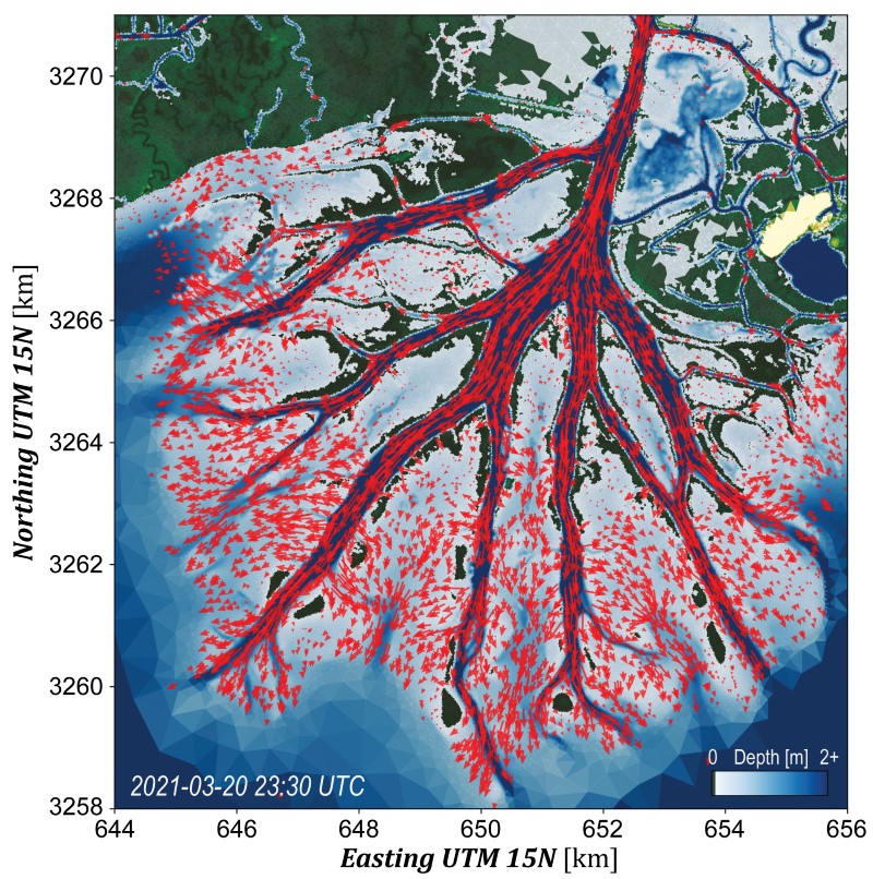
Delta-X: Calibrated ANUGA Hydrodynamic Outputs for the Atchafalaya Basin, MRD, LA
National Aeronautics and Space Administration —
This dataset provides ANUGA hydrodynamic modeling results and input run-scripts for the Atchafalaya basin in the Mississippi River Delta in southern Louisiana, USA,... -
Federal
CATS-ISS Level 2 Operational Day Mode 7.1 Version 3-01 5 km Profile
National Aeronautics and Space Administration —
CATS-ISS_L2O_D-M7.1-V3-01_05kmPro is the Cloud-Aerosol Transport System (CATS) International Space Station (ISS) Level 2 Operational Day Mode 7.1 Version 3-01 5 km... -
Federal
ACE Solar Wind Electron, Proton, and Alpha Monitor (SWEPAM) Plasma Moments, Preliminary Values, Key Parameter (K0), 5 min Data
National Aeronautics and Space Administration —
The ACE Browse Data are designed for monitoring large-scale Particle and Field Behavior and for selecting interesting Time Periods. The Data are automatically... -
Federal
Ground-Based GNSS-based Upper Atmospheric Realtime Disaster Information and Alert Network (GUARDIAN) GPS daily accumulated real-time Precise Orbit Determination (POD) Clock Corrections (1-second sampling, 24-hour files) from NASA CDDIS
National Aeronautics and Space Administration —
This product contains a high-rate time series of clock biases for healthy satellites in the GPS constellation that are accumulated every minute throughout the day. In... -
Federal
NOAA Soundings IMPACTS
National Aeronautics and Space Administration —
The NOAA Soundings IMPACTS dataset was collected from January 1, 2020, through March 1, 2023, during the Investigation of Microphysics and Precipitation for Atlantic... -
Federal
Ground temperatures in ice-cemented ground at Linnaeus Terrace, Dry Valleys, Antarctica, Version 1
National Aeronautics and Space Administration —
Soil temperatures were measured with Campbell 107 soil thermistors. Thermistors were placed at 0, 17, 23 (just above the ice-cemented permafrost) and 40 cm depth. To... -
Federal
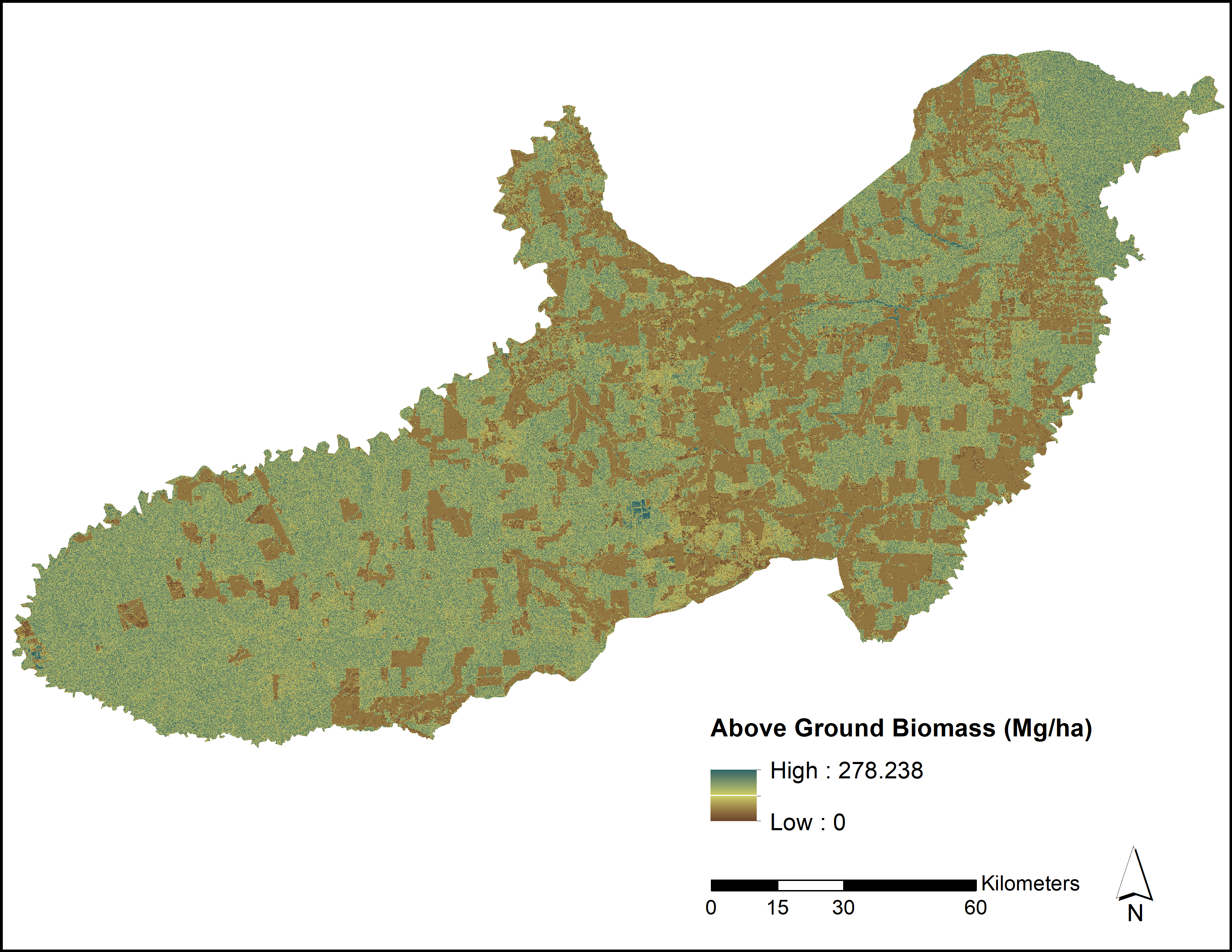
LiDAR and PALSAR-Derived Forest Aboveground Biomass, Paragominas, Para, Brazil, 2012
National Aeronautics and Space Administration —
This dataset provides estimates of forest aboveground biomass for three study areas and the entire Paragominas municipality, in Para, Brazil, in 2012. Aboveground... -
Federal
ABoVE: Methane Flux across Two Thermokarst Lake Ecosystems, Interior Alaska, 2018
National Aeronautics and Space Administration —
This dataset provides diffusive methane (CH4) fluxes collected from two thermokarst lakes in the Goldstream Valley, north of Fairbanks in interior Alaska. Fluxes were... -
Federal
Photochemistry measurements made along the mid-Atlantic and New England coastal regions
National Aeronautics and Space Administration —
Measurements made along the mid-Atlantic and New England coastal regions. -
Federal
Aqua/AIRS L2 Cloud-Cleared Infrared Radiances (AIRS+AMSU+HSB) V7.0 at GES DISC
National Aeronautics and Space Administration —
The Atmospheric Infrared Sounder (AIRS) is a grating spectrometer (R = 1200) aboard the second Earth Observing System (EOS) polar-orbiting platform, EOS Aqua. In... -
Federal
SNF Site Characterization Validation
National Aeronautics and Space Administration —
This data set documentation is currently in work. In the interim, an abstract of the entire Superior National Forest (SNF) data collection activity from which the SNF... -
Federal
MODIS/Aqua Near Real Time (NRT) Surface Reflectance Daily L2G Global 500m SIN Grid
National Aeronautics and Space Administration —
The MODIS Near Real Time (NRT) Surface Reflectance Daily L2G Global 500m SIN Grid product, MYD09GHK, is a seven-band product computed from the MODIS Level 1B land... -
Federal
Measurements from Mumford Cove, Connecticut
National Aeronautics and Space Administration —
Measurements made in and around Mumford Cove, Connecticut since 2015.

Official websites use .gov
A
.gov website belongs to an official government
organization in the United States.
Secure .gov websites use HTTPS
A
lock (
) or https:// means you’ve safely connected to
the .gov website. Share sensitive information only on official,
secure websites.