
-
Federal
Aquarius Celestial Sky Microwave Emission Map Ancillary Dataset V1.0
National Aeronautics and Space Administration —
This datasets contains three maps of L-band (wavelength = 21 cm) brightness temperature of the celestial sky ("Galaxy") used in the processing of the NASA Aquarius... -
Federal
SARP 2017 Data
National Aeronautics and Space Administration —
SARP_2017_Data is the data collected onboard the Wallops C-23 aircraft during the 2017 deployment of the Student Airborne Research Program (SARP) mission. Data... -
Federal
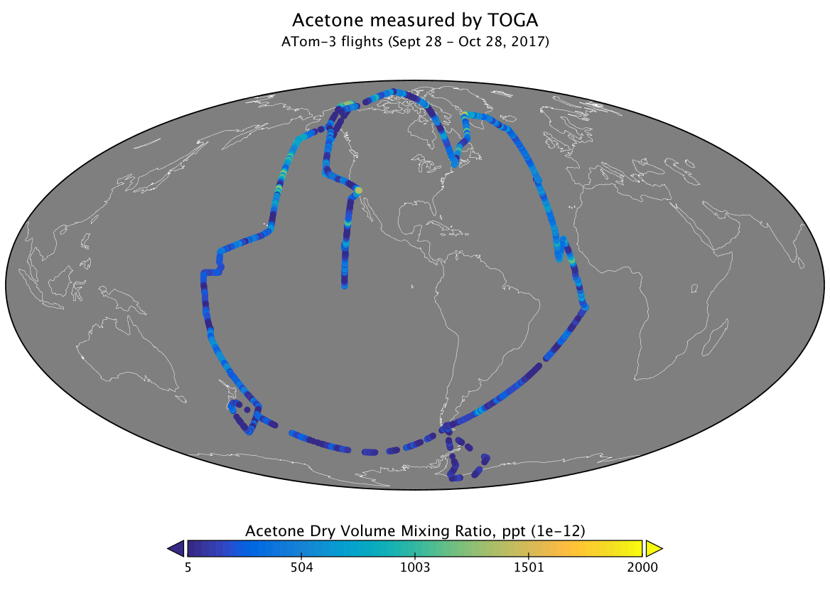
ATom: Volatile Organic Compounds (VOCs) from the TOGA instrument, Version 2
National Aeronautics and Space Administration —
This dataset provides concentrations of volatile organic compounds (VOCs) measured by the Trace Organic Gas Analyzer (TOGA) during the four ATom campaigns. These data... -
Federal
JASON-1 ENHANCED JASON MICROWAVE RADIOMETER
National Aeronautics and Space Administration —
The enhanced Jason-1 Microwave Radiometer (JMR) corrections contains better wet tropospheric path delay corrections along with better land, rain and ice flagging for... -
Federal
SAFARI 2000 CV-580 Aerosol and Cloud Data, Dry Season 2000 (CARG)
National Aeronautics and Space Administration —
The Cloud and Aerosol Research Group (CARG) of the University of Washington participated in the SAFARI-2000 Dry Season Aircraft campaign with their Convair-580... -
Federal
TES/Aura L2 Methane Nadir Special Observation V008
National Aeronautics and Space Administration —
TL2CH4NS_8 is the Tropospheric Emission Spectrometer (TES)/Aura Level 2 Methane Nadir Special Observation Version 8 data product. TES was an instrument aboard NASA's... -
Federal
LBA-ECO LC-04 THMB Model Simulations for the Amazon and Tocantins Basins: 1939-1998
National Aeronautics and Space Administration —
The model output data provided were generated by the THMB 1.2 (Terrestrial Hydrology Model with Biogeochemistry) model which simulates the flow of water through... -
Federal
ABoVE: White Spruce Photosynthetic and Leaf Traits, Alaska and New York, 2017
National Aeronautics and Space Administration —
This dataset provides measurements of gas exchange (light response curves, Kok curves and ACi curves), leaf traits (carbon, nitrogen, and specific leaf area), leaf... -
Federal
SMEX02 Tower-Based Radiometric Surface Temperature, Walnut Creek, Iowa, Version 1
National Aeronautics and Space Administration —
This data set includes air temperature, vapor pressure, wind speed, and brightness temperatures taken at 12 flux towers as part of the Soil Moisture Experiment 2002... -
Federal
TRACE-P In Situ DC-8 Meteorology and Navigation Data
National Aeronautics and Space Administration —
TRACE-P_MetNav_AircraftInSitu_DC8_Data is the in situ meteorology and navigation data collected onboard the DC-8 aircraft during the Transport and Chemical Evolution... -
Federal
Arctic Tundra Flux Study in the Kuparuk River Basin (Alaska), 1994-1996
National Aeronautics and Space Administration —
CO2 and water vapor fluxes and ecosystem characteristics were measured at 24 sites along a 317-km transect from the Arctic coast to the latitudinal treeline in Alaska... -
Federal
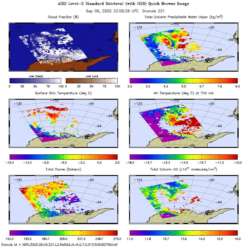
AIRS/Aqua L2 Standard Physical Retrieval (AIRS+AMSU+HSB) V006 (AIRH2RET) at GES DISC
National Aeronautics and Space Administration —
The Atmospheric Infrared Sounder (AIRS) is a grating spectrometer (R = 1200) aboard the second Earth Observing System (EOS) polar-orbiting platform, EOS Aqua. In... -
Federal
GHRSST Level 2P Global 1m Sea Surface Temperature from the Advanced Very High Resolution Radiometer (AVHRR) on the MetOp-A satellite produced by NAVO
National Aeronautics and Space Administration —
A global Group for High Resolution Sea Surface Temperature (GHRSST) Level 2P dataset based on multi-channel sea surface temperature (SST) retrievals generated in... -
Federal
Delta-X: Bed and Suspended Sediment Grain Size, MRD, LA, USA, 2019-2021, V3
National Aeronautics and Space Administration —
This dataset includes sediment concentration and grain size distribution measurements from suspended and bed sediment samples collected in the Atchafalaya River and... -
Federal
Aquarius CAP Level 3 Wind Speed Standard Mapped Image Monthly Data V5.0
National Aeronautics and Space Administration —
Version 5.0 Aquarius CAP Level 3 products are the fourth release of the AQUARIUS/SAC-D mapped salinity and wind speed data based on the Combined Active Passive (CAP)... -
Federal
CMS: Global 0.5-deg Wetland Methane Emissions and Uncertainty (WetCHARTs v1.3.3)
National Aeronautics and Space Administration —
This dataset provides global monthly wetland methane (CH4) emissions estimates at 0.5 by 0.5-degree resolution for the period 2001-01-01 to 2022-08-31 that were... -
Federal
Enhanced MODIS Airborne Simulator (eMAS) Calibrated, Geolocated Radiances L1B 50m Data
National Aeronautics and Space Administration —
The Enhanced Moderate Resolution Imaging Spectroradiometer (MODIS) Airborne Simulator (eMAS)instrument is maintained and operated by the Airborne Sensor Facility at... -
Federal
Arctic Ice Dynamics Joint Experiment (AIDJEX) Second Pilot Study, March - May 1972: A Documentary Film, Version 1
National Aeronautics and Space Administration —
The project described in this documentary was a pilot study conducted in 1972 in preparation for the AIDJEX main experiment of 1975 to 1976. The study included a main... -
Federal
CERES Energy Balanced and Filled (EBAF) TOA Monthly means data in netCDF Edition4.1
National Aeronautics and Space Administration —
CERES_EBAF-TOA_Edition4.1 is the Clouds and the Earth's Radiant Energy System (CERES) Energy Balanced and Filled (EBAF) Top-of-Atmosphere (TOA) Monthly means data in... -
Federal
ASTER Global Water Bodies Database Attributes NetCDF V001
National Aeronautics and Space Administration —
The Terra Advanced Spaceborne Thermal Emission and Reflection Radiometer (ASTER) Global Water Bodies Database (ASTWBD) Version 1 data product provides global coverage...

Official websites use .gov
A
.gov website belongs to an official government
organization in the United States.
Secure .gov websites use HTTPS
A
lock (
) or https:// means you’ve safely connected to
the .gov website. Share sensitive information only on official,
secure websites.