
-
Federal
GHRSST Level 2P Global 1m Sea Surface Temperature from the Advanced Very High Resolution Radiometer (AVHRR) on the MetOp-A satellite produced by NAVO
National Aeronautics and Space Administration —
A global Group for High Resolution Sea Surface Temperature (GHRSST) Level 2P dataset based on multi-channel sea surface temperature (SST) retrievals generated in... -
Federal
Northern and Mid-Latitude Soil Database, Version 1, R1
National Aeronautics and Space Administration —
The U.S. Department of Agriculture, Agriculture and Agri-Food Canada, the Russian Academy of Agricultural Sciences, the University of Copenhagen Institute of... -
Federal
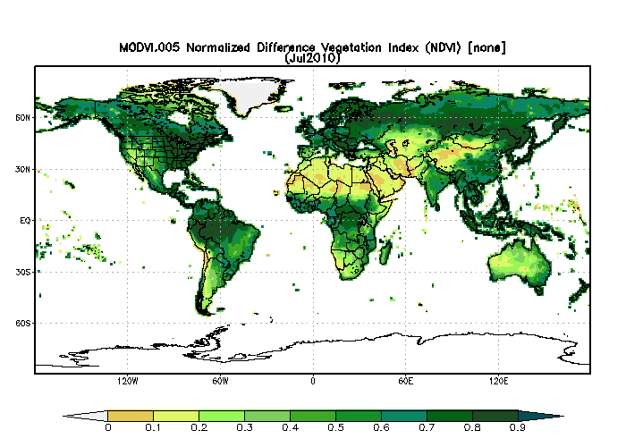
MODIS/Terra Monthly Vegetation Indices Global 1x1 degree V005 (MODVI) at GES DISC
National Aeronautics and Space Administration —
The global monthly gridded MODIS vegetation indices product is derived from the standard 0.05 CMG MODIS Terra Vegetation Indices Monthly product MOD13C2 (Huete et al,... -
Federal
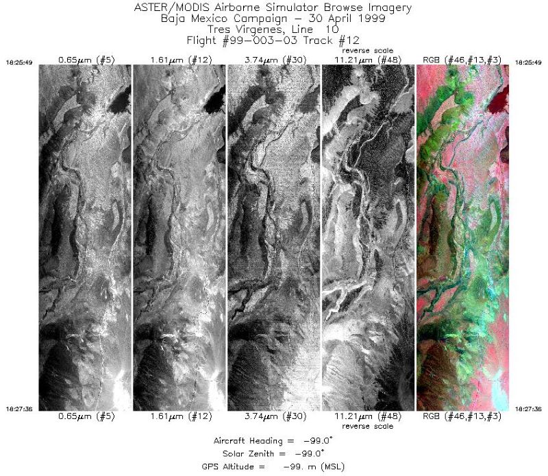
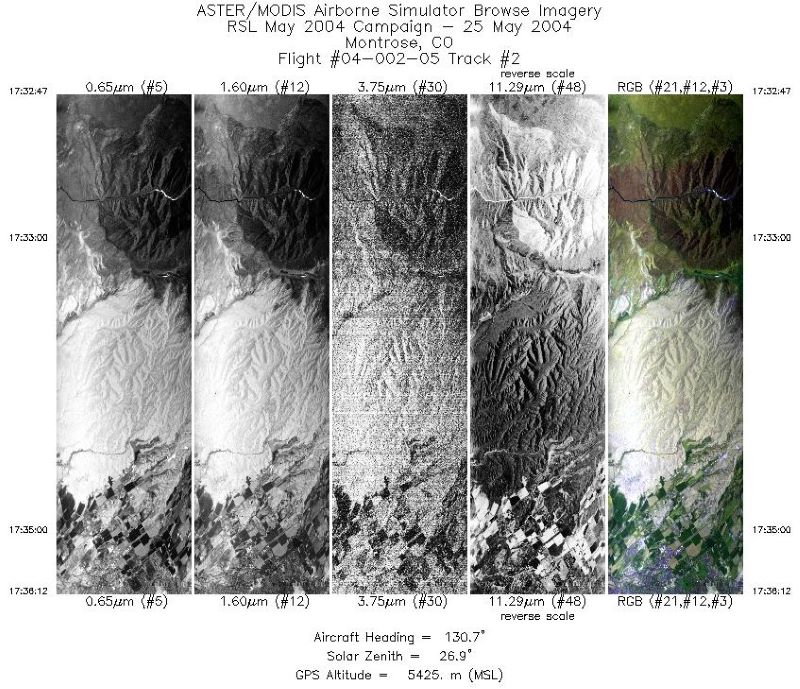
MASTER: Airborne Science, Baja Mexico-Nevada, April-May, 1999
National Aeronautics and Space Administration —
This dataset includes Level 1B (L1B) data products from the MODIS/ASTER Airborne Simulator (MASTER) instrument. The spectral data were collected during 7 flights... -
Federal
Aqua/AIRS L3 Monthly Support Monthly Product (AIRS+AMSU+HSB) 1 degree x 1 degree V7.0 at GES DISC
National Aeronautics and Space Administration —
The Atmospheric Infrared Sounder (AIRS) is a grating spectrometer (R = 1200) aboard the second Earth Observing System (EOS) polar-orbiting platform, EOS Aqua. In... -
Federal
MODIS Aqua Level 3 SST MID-IR 8 Day 9km Nighttime V2019.0
National Aeronautics and Space Administration —
Day and night spatially gridded (L3) global NASA skin sea surface temperature (SST) products from the Moderate-resolution Imaging Spectroradiometer (MODIS) onboard... -
Federal
RLC Forest Fire Images in Russia, 1998-1999
National Aeronautics and Space Administration —
This data set is made up of images of forest fires in Russia from NOAA's Operational Significant Event Imagery (OSEI) archive (http://www.osei.noaa.gov) for the 1998... -
Federal
CAMEX-3 ER-2 Millimeter-wave Imaging Radiometer (MIR)
National Aeronautics and Space Administration —
The CAMEX-3 ER-2 Millimeter-wave Imaging Radiometer (MIR) dataset is a browse-only dataset containing plots of brightness temperature measurements collected by the... -
Federal
ECOSTRESS Swath Geolocation Instantaneous L1B Global 70 m V002
National Aeronautics and Space Administration —
The ECOsystem Spaceborne Thermal Radiometer Experiment on Space Station (ECOSTRESS) mission measures the temperature of plants to better understand how much water... -
Federal
GEWEX SRB Integrated Product (Rel-4_1) Longwave Daily Average by Local Land-only Fluxes
National Aeronautics and Space Administration —
GEWEXSRB_Rel4_1-IP_Longwave_daily_landonly_local is the Global Energy and Water Exchanges (GEWEX) Surface Radiation Budget (SRB) Integrated Product (Rel-4) Longwave... -
Federal
MISR Level 2 TOA/Cloud Stereo Product subset for the VBBE region V002
National Aeronautics and Space Administration —
VBEMI2ST_002 is the Multi-angle Imaging SpectroRadiometer (MISR) Level 2 TOA/Cloud Stereo Product subset for the VBBE region version 2. It contains the... -
Federal
AVISO Level 4 Absolute Dynamic Topography for Climate Model Comparison Number of Observations
National Aeronautics and Space Administration —
These data are the numer of observations used to generate the AVISO Level 4 Absolute Dynamic Topography for Climate Model Comparison Number of Observations data set... -
Federal
MODIS Aqua L3 occurrence frequency of low-cloud types monthly mean and annual mean 2x2 degree resolution V001 (MYD_L3_OFLCT) at GES DISC
National Aeronautics and Space Administration —
This product is composed of a beta version for a product from the MODerate resolution Imaging Spectrometer (MODIS) on board the Aqua satellite. MODIS Aqua L3... -
Federal
NAAMES C-130 Navigational and Meteorological Data, Version 1
National Aeronautics and Space Administration —
NAAMES_MetNav_AircraftInSitu_Data are in situ meteorological and navigational measurements collected onboard the C-130 aircraft during the North Atlantic Aerosols and... -
Federal
MLS/Aura Level 3 Monthly Binned Cloud Ice (IWC) on Assorted Grids V004 (ML3MBIWC) at GES DISC
National Aeronautics and Space Administration —
ML3MBIWC is the EOS Aura Microwave Limb Sounder (MLS) monthly binned on various vertical grids product for cloud ice water content (IWC) derived from radiances... -
Federal
MOPITT Beta CO gridded daily means (Near and Thermal Infrared Radiances) V109
National Aeronautics and Space Administration —
MOP03J_109 is the Measurements Of Pollution In The Troposphere (MOPITT) Beta CO gridded daily means (Near and Thermal Infrared Radiances) version 109 product is an... -
Federal
First ISCCP Regional Experiment (FIRE) Atlantic Stratocumulus Transition Experiment (ASTEX) United Kingdom Meteorological Office (UKMO) C-130 Aircraft Data
National Aeronautics and Space Administration —
The First ISCCP Regional Experiments have been designed to improve data products and cloud/radiation parameterizations used in general circulation models (GCMs).... -
Federal
ATTREX Global Hawk UAS Meteorological and Navigational Measurements
National Aeronautics and Space Administration —
ATTREX-Aircraft_navigational_meteorological_Measurements are in-situ navigational and meteorological measurements collected onboard the Global Hawk Uninhabited Aerial...

Official websites use .gov
A
.gov website belongs to an official government
organization in the United States.
Secure .gov websites use HTTPS
A
lock (
) or https:// means you’ve safely connected to
the .gov website. Share sensitive information only on official,
secure websites.