
-
Federal
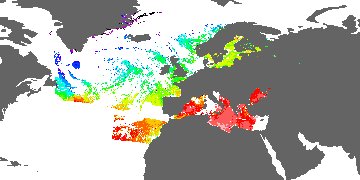
First ISCCP Regional Experiment (FIRE) Atlantic Stratocumulus Transition Experiment (ASTEX) University of Washington C-131A Aircraft Data
National Aeronautics and Space Administration —
The First ISCCP Regional Experiments (FIRE) have been designed to improve data products and cloud/radiation parameterizations used in general circulation models... -
Federal
Doppler Orbitography and Radiopositioning Integrated by Satellite (DORIS) Positions Products from NASA CDDIS
National Aeronautics and Space Administration —
Station position and velocity solutions (weekly and cumulative) in Software INdependent EXchange (SINEX) format derived from analysis of Doppler Orbitography by... -
Federal
SWOT Level 2 KaRIn Low Rate Sea Surface Height Data Product - Basic, Version C
National Aeronautics and Space Administration —
The SWOT Level 2 KaRIn Low Rate Sea Surface Height Basic Data Product from the Surface Water Ocean Topography (SWOT) mission provides global sea surface height and... -
Federal
ROSETTA-ORBITER 67P OSINAC 4 ESC3-MTP021 RDR-STR-REFL V1.0
National Aeronautics and Space Administration —
This CODMAC level 4 data set contains solar stray light corrected, radiometric calibrated and geometric distortion corrected (resampled) image data in in reflectance... -
Federal
KORUS-AQ Ancillary Analysis Data
National Aeronautics and Space Administration —
KORUSAQ_Analysis_Data are supplementary ancillary analysis files collected during the KORUS-AQ field campaign. This collection includes plume flags, co/co2 ratios,... -
Federal
GPM GMI (GPROF) Radiometer Precipitation Profiling L2A 1.5 hours 13 km V07 (GPM_2AGPROFGPMGMI) at GES DISC
National Aeronautics and Space Administration —
Version 07 is the current version of the data set. Older versions will no longer be available and have been superseded by Version 07. The 2AGPROF (Goddard Profiling)... -
Federal
GHRSST Level 3C North Atlantic Regional (NAR) subskin Sea Surface Temperature from SNPP/VIIRS (GDS V2) produced by OSI SAF
National Aeronautics and Space Administration —
A regional Group for High Resolution Sea Surface Temperature (GHRSST) Level 3 Collated (L3C) dataset for the North Atlantic Region (NAR) based on retrievals from the... -
Federal
NACP MCI: CO2 Flux from Inversion Modeling, Upper Midwest Region, USA, 2007
National Aeronautics and Space Administration —
This data set provides estimates of Net Ecosystem Exchange (NEE) flux for the U.S. Upper Midwest at 0.5-degree resolution for the year 2007. Estimates were produced... -
Federal
SMEX04 QuikSCAT/SeaWinds Backscatter Data: Sonora, Version 1
National Aeronautics and Space Administration —
This data set includes data collected by the SeaWinds scatterometer on NASA's Quick Scatterometer (QuikSCAT) satellite collected backscatter data. -
Federal
RSS SSMIS OCEAN PRODUCT GRIDS DAILY FROM DMSP F16 NETCDF V7
National Aeronautics and Space Administration —
The RSS SSMIS Ocean Product Grids Daily from DMSP F16 netCDF dataset is part of the collection of Special Sensor Microwave/Imager (SSM/I) and Special Sensor Microwave... -
Federal
ASTER Global Emissivity Dataset 100 meter Binary
National Aeronautics and Space Administration —
The AG100B Version 3 dataset was decommissioned as of December 14, 2016. Users are encouraged to use the ASTER Global Emissivity Dataset 100-meterFederalWLDAS Noah-MP 3.6 Land Surface Model L4 Daily 0.01 degree x 0.01 degree Version D1.0 (WLDAS_NOAHMP001_DA1) at GES DISC
National Aeronautics and Space Administration —
The Western Land Data Assimilation System (WLDAS), developed at Goddard Space Flight Center (GSFC) and funded by the NASA Western Water Applications Office, provides...FederalAircraft Flux-Filtered: Univ. Col. (FIFE)
National Aeronautics and Space Administration —
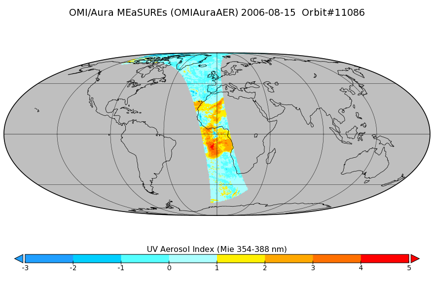
The NCAR King Air participation in FIFE-1987 and FIFE-1989 was part of a coordinated atmospheric boundary layer component which included other aircraft, surface...FederalOMI/Aura Near UV Aerosol Index, Optical Depth and Single Scattering Albedo 1-Orbit L2 13x24km
National Aeronautics and Space Administration —
As part of the NASA's Making Earth System Data Records for Use in Research Environments (MEaSUREs) program, this projects describes a multi-decadal Fundamental...FederalASTER Level 1 Precision Terrain Corrected Registered At-Sensor Radiance V031
National Aeronautics and Space Administration —
The Terra Advanced Spaceborne Thermal Emission and Reflection Radiometer (ASTER) Level 1 Precision Terrain Corrected Registered At-Sensor Radiance (AST_L1T) Version...FederalBOREAS AES Five-day Averaged Surface Meteorological and Upper Air Data
National Aeronautics and Space Administration —
The Canadian Atmospheric Environment Service (AES) provided BOREAS with hourly and daily surface meteorological data from 23 of the AES meteorological stations...FederalNWS Daily Climatology Data: 1989 (SNF)
National Aeronautics and Space Administration —
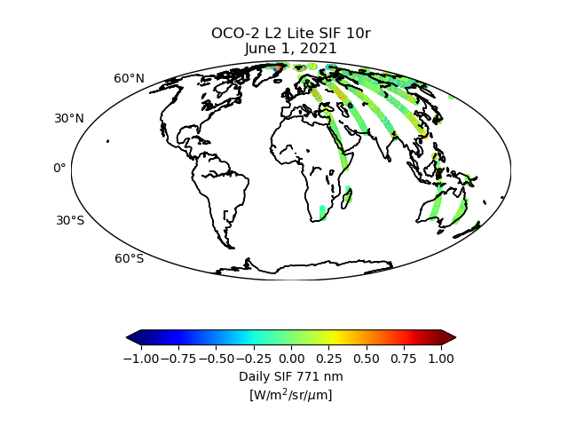
Weather data were collected by the National Weather Service in International Falls, Minnesota. International Falls is about 80 miles from the SNF, but the weather...FederalOCO-2 Level 2 bias-corrected solar-induced fluorescence and other select fields from the IMAP-DOAS algorithm aggregated as daily files, Retrospective processing V10r (OCO2_L2_Lite_SIF) at GES DISC
National Aeronautics and Space Administration —
Version 10r is the current version of the data set. Older versions will no longer be available and are superseded by Version 10r. The OCO-2 SIF Lite files contain...FederalMERRA-2 instU_3d_ana_Np: 3d,diurnal,Instantaneous,Pressure-Level,Analysis,Analyzed Meteorological Fields 0.625 x 0.5 degree V5.12.4 (M2IUNPANA) at GES DISC
National Aeronautics and Space Administration —
M2IUNPANA (or instU_3d_ana_Np) is an instantaneous 3-dimensional monthly diurnal means data collection in Modern-Era Retrospective analysis for Research and...9,585 datasets found

Official websites use .gov
A
.gov website belongs to an official government
organization in the United States.
Secure .gov websites use HTTPS
A
lock (
) or https:// means you’ve safely connected to
the .gov website. Share sensitive information only on official,
secure websites.