
-
Federal
MODIS/Terra Land Surface Temperature/Emissivity Daily L3 Global 0.05Deg CMG V006
National Aeronautics and Space Administration —
The MOD11C1 Version 6 data product was decommissioned on July 31, 2023. Users are encouraged to use the MOD11C1... -
Federal
Forest Aboveground Biomass for Maryland, USA
National Aeronautics and Space Administration —
This dataset includes estimates of annual forest aboveground biomass over the state of Maryland, USA, for the period 1984-2023. It was generated by a modeling... -
Federal
Measurement of Air Pollution from Satellites (MAPS) Office of Space and Terrestrial Applications - 3 (OSTA3) Carbon Monoxide Second by Second data
National Aeronautics and Space Administration —
MAPS Overview The MAPS experiment measures the global distribution of carbon monoxide (CO) mixing ratios in the free troposphere. Because of MAPS' previous flights on... -
Federal
UAVSAR_INSAR_INTERFEROGRAM
National Aeronautics and Space Administration —
UAVSAR Repeat Pass Interferometry Scene -
Federal
SatCORPS CERES GEO Edition 4 Meteosat-7 Full Disk Version 2
National Aeronautics and Space Administration —
CER_GEO_Ed4_MET07_FD_V02 is the Satellite Cloud and Radiation Property retrieval System (SatCORPS) Clouds and the Earth's Radiant Energy System (CERES) Geostationary... -
Federal
CERES ERBE-like Monthly Regional Averages NOAA-20 FM6 Edition1
National Aeronautics and Space Administration —
CER_ES9_NOAA20-FM6_Edition1, CERES ERBE-like Monthly Regional Averages NOAA-20 FM6 Edition 1, contains TOA fluxes from the Clouds and the Earth's Radiant Energy... -
Federal
Soil CH4 and CO2 Profile Data from NSA Tower Sites
National Aeronautics and Space Administration —
The BOREAS TGB-01 team made numerous measurements of trace gas concentrations and fluxes at various NSA sites. This data set contains methane (CH4) and carbon dioxide... -
Federal
Gridded Altimeter Fields with Enhanced Coastal Coverage
National Aeronautics and Space Administration —
The Gridded Altimeter Fields with Enhanced Coastal Coverage data product contains Sea Surface Height Anomalies (SSHA or SLA) and zonal and meridional geostrophic... -
Federal
IKONOS Level 1B Multispectral 4-Band Satellite Imagery
National Aeronautics and Space Administration —
The IKONOS Level 1B Multispectral 4-Band Imagery collection contains satellite imagery acquired from Maxar Technologies (formerly known as DigitalGlobe) by the... -
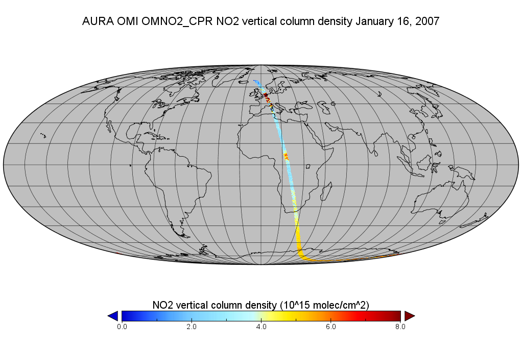
Federal
OMI/Aura Level 2 Nitrogen Dioxide (NO2) Trace Gas Column Data 1-Orbit subset Swath along CloudSat track 1-Orbit Swath 13x24 km
National Aeronautics and Space Administration —
This is a CloudSat-collocated subset of the original product OMNO2, for the purposes of the A-Train mission. The goal of the subset is to select and return OMI data... -
Federal
CERES and GEO-Enhanced TOA, Within-Atmosphere and Surface Fluxes, Clouds and Aerosols Monthly-Averaged 1-Hourly Terra-Aqua Edition4A
National Aeronautics and Space Administration —
CER_SYN1deg-MHour_Terra-Aqua-MODIS_Edition4A is the Clouds and the Earth's Radiant Energy System (CERES) and geostationary (GEO)-Enhanced Top-of-Atmosphere (TOA),... -
Federal
MODIS/Aqua+Terra Global Flood Product L3 NRT 250m 1-day GeoTIFF
National Aeronautics and Space Administration —
The MODIS/Aqua+Terra Global Flood Product L3 Near Real Time (NRT) 250m 1-day GeoTIFF (MCDWD_L3_F1_NRT) (beta) provides daily maps of flooding globally. The Global... -
Federal
ASTER L2 Surface Temperature V003
National Aeronautics and Space Administration —
The Terra Advanced Spaceborne Thermal Emission and Reflection Radiometer (ASTER) Surface Kinetic Temperature (AST_08) is generated using the five Thermal Infrared... -
Federal
SatCORPS CERES GEO Edition 4 GOES-9 Southern Hemisphere Version 1.0
National Aeronautics and Space Administration —
CER_GEO_Ed4_GOE09_SH_V01 is the Satellite Cloud and Radiation Property retrieval System (SatCORPS) Clouds and the Earth's Radiant Energy System (CERES) Geostationary... -
Federal
SMAP_L1C_SIGMA_NAUGHT_HIGH_RES_QA_V002
National Aeronautics and Space Administration —
SMAP Level 1C Sigma Naught High Res Data Quality Info Version 2 -
Federal
MODIS Aqua Level 3 SST Thermal IR Daily 9km Daytime V2019.0
National Aeronautics and Space Administration —
Day and night spatially gridded (L3) global NASA skin sea surface temperature (SST) products from the Moderate-resolution Imaging Spectroradiometer (MODIS) onboard... -
Federal
CAMEX-3 ER-2 Millimeter-wave Imaging Radiometer (MIR)
National Aeronautics and Space Administration —
The CAMEX-3 ER-2 Millimeter-wave Imaging Radiometer (MIR) dataset is a browse-only dataset containing plots of brightness temperature measurements collected by the... -
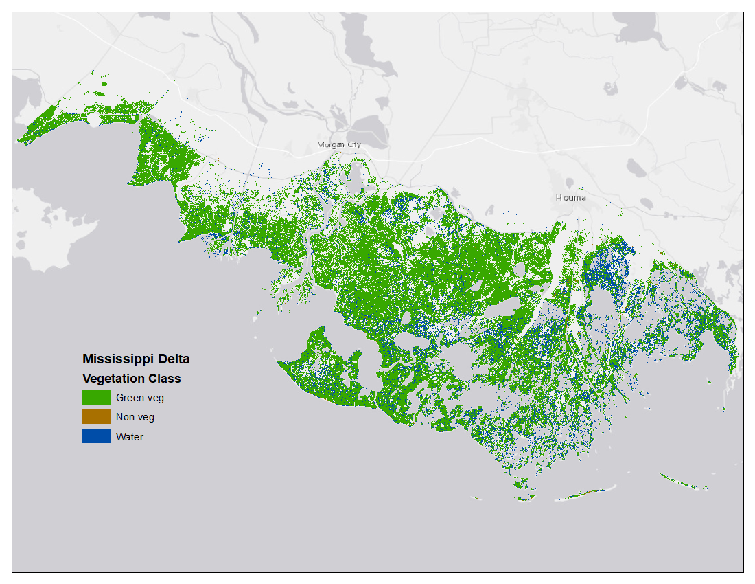
Federal
Vegetation and Open Water High-Resolution Maps for Selected US Tidal Marshes, 2015
National Aeronautics and Space Administration —
This dataset provides maps of tidal marsh green vegetation, non-vegetation, and open water for six estuarine regions of the conterminous United States: Cape Cod, MA;... -
Federal
TOVS LMD MONTHLY GRIDS from NOAA-10 V01 (TOVSBMNG) at GES DISC
National Aeronautics and Space Administration —
Level 3 parameters from HIRS/2 and MSU radiances using the Improved Initialization Inversion (3I) classification retrieval scheme by the Laboratoire de Meteorologie...

Official websites use .gov
A
.gov website belongs to an official government
organization in the United States.
Secure .gov websites use HTTPS
A
lock (
) or https:// means you’ve safely connected to
the .gov website. Share sensitive information only on official,
secure websites.