
-
Federal
NOAA/WDS Paleoclimatology - Esper - Mainz EDN01 - PISY - ITRDB DEU438
National Oceanic and Atmospheric Administration, Department of Commerce —
This archived Paleoclimatology Study is available from the NOAA National Centers for Environmental Information (NCEI), under the World Data Service (WDS) for... -
Federal
NOAA/WDS Paleoclimatology - Weber - REI - ABAL - ITRDB CHE555
National Oceanic and Atmospheric Administration, Department of Commerce —
This archived Paleoclimatology Study is available from the NOAA National Centers for Environmental Information (NCEI), under the World Data Service (WDS) for... -
Federal
NOAA/WDS Paleoclimatology - Filion - Lac Bienville Est - LALA - ITRDB CAN696
National Oceanic and Atmospheric Administration, Department of Commerce —
This archived Paleoclimatology Study is available from the NOAA National Centers for Environmental Information (NCEI), under the World Data Service (WDS) for... -
Federal
Surface underway measurements of partial pressure of carbon dioxide (pCO2) during the Antarctic Research and Supply Vessel (ARSV) Laurence M. Gould expeditions in the the Southern Ocean, Drake Passage, South Atlantic Ocean in 2024 (NCEI Accession 0302064)
National Oceanic and Atmospheric Administration, Department of Commerce —
This dataset includes surface underway, chemical, meteorological and physical data collected from ARSV Laurence M. Gould in the Southern Ocean, Drake Passage, South... -
Federal
Surface underway measurements of partial pressure of carbon dioxide (pCO2), sea surface salinity, temperature and other parameters during the ship of opportunity (SOOP) M/S New Century 2 cruises in the Pacific Ocean, Atlantic Ocean and Caribbean Sea in 2023 (NCEI Accession 0287492)
National Oceanic and Atmospheric Administration, Department of Commerce —
This dataset includes surface underway, chemical, meteorological and physical data collected from M/S New Century 2 in the Pacific Ocean, Caribbean Sea, Atlantic... -
Federal
Dissolved inorganic carbon, total alkalinity, pH on total scale, and other variables collected from discrete samples and profile observations during the R/V F. G. Walton Smith cruise WS24139 (EXPOCODE 33WA20240518) in the North Atlantic Ocean, Gulf of Mexico from from 2024-05-18 to 2024-05-24 (NCEI Accession 0298979)
National Oceanic and Atmospheric Administration, Department of Commerce —
Near-shore estuarine and coastal regions are where most recreational fishing and tourism occur, yet they are vastly under-sampled. Their susceptibility to OA is not... -
Federal
MODIS/Terra Land Surface Temperature/3-Band Emissivity Daily L3 Global 0.05Deg CMG V061
National Aeronautics and Space Administration —
A suite of Moderate Resolution Imaging Spectroradiometer (MODIS) Land Surface Temperature and Emissivity (LST&E) products are available in Collection 6.1. The... -
Federal
MODIS/Aqua Thermal Anomalies/Fire 5-Min L2 Swath 1km NRT
National Aeronautics and Space Administration —
The MODIS/Aqua Thermal Anomalies/Fire 5-Min L2 Swath 1km Near Real Time (NRT), short name MYD14, product is primarily derived from MODIS 4- and 11-micrometer... -
Federal
MLS/Aura Level 3 Monthly Binned Nitrous Oxide (N2O) Mixing Ratio on Assorted Grids V005 (ML3MBN2O) at GES DISC
National Aeronautics and Space Administration —
ML3MBN2O is the EOS Aura Microwave Limb Sounder (MLS) monthly binned on various vertical grids product for nitrous oxide (N2O) derived from radiances measured... -
Federal
MMR Calibration Data (FIFE)
National Aeronautics and Space Administration —
The MMR Calibration Data Set contains radiance data collected in the summer of 1987 and in July and August of 1989 via a Modular Multiband Radiometer (MMR)... -
Federal
MLS/Aura Level 3 Daily Binned Hydroxyl (OH) Mixing Ratio on Zonal and Similar Grids V004 (ML3DZOH) at GES DISC
National Aeronautics and Space Administration —
ML3DZOH is the EOS Aura Microwave Limb Sounder (MLS) daily binned on zonal and assorted vertical grids product for hydroxyl (OH) derived from radiances measured by... -
Federal
MLS/Aura Level 3 Daily Binned Nitrous Oxide (N2O) Mixing Ratio on Assorted Grids V005 (ML3DBN2O) at GES DISC
National Aeronautics and Space Administration —
ML3DBN2O is the EOS Aura Microwave Limb Sounder (MLS) daily binned on various vertical grids product for nitrous oxide (N2O) derived from radiances measured primarily... -
Federal
MISR Level 2 TOA/Cloud Albedo parameters V002
National Aeronautics and Space Administration —
Multi-angle Imaging SpectroRadiometer (MISR) is designed to view Earth with cameras pointed in 9 different directions. As the instrument flies overhead, each piece of... -
Federal
Measurement of Air Pollution from Satellites (MAPS) Space Radar Laboratory - 1 (SRL1) Carbon Monoxide Second by Second data
National Aeronautics and Space Administration —
MAPS Overview The MAPS experiment measures the global distribution of carbon monoxide (CO) mixing ratios in the free troposphere. Because of MAPS' previous flights on... -
Federal
Measurements from the Baltic Sea in 1999
National Aeronautics and Space Administration —
Measurements from the Baltic Sea in 1999. -
Federal
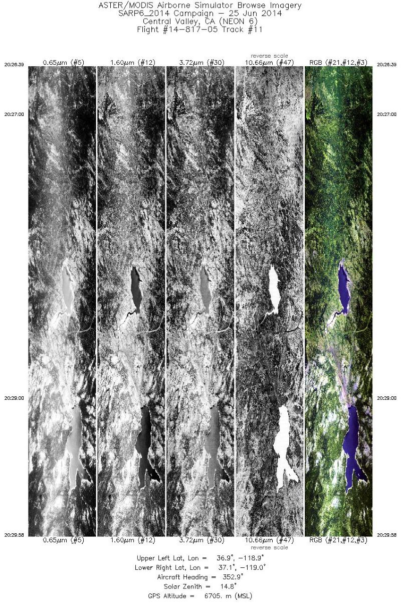
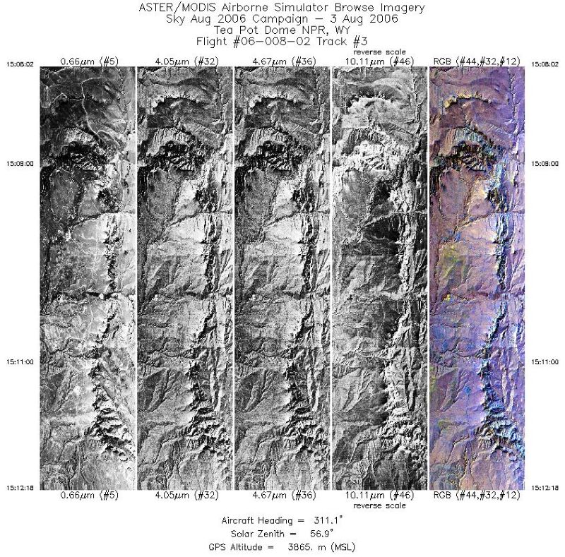
MASTER: Costa Rica Airborne Research and Technology Applications (CARTA), 2005
National Aeronautics and Space Administration —
This dataset includes Level 1B (L1B) data products from the MODIS/ASTER Airborne Simulator (MASTER) instrument. The spectral data were collected during 23 flights... -
Federal
LANDMET Ancillary Monthly Mean Effective and Spectral Albedo Data L3 V1 (LANDMET_ANC_TESA) at GES DISC
National Aeronautics and Space Administration —
This is an ancillary product containing the total effective surface albedo at solar wavelengths originated from the ISCCP FD radiative fluxes product, and the... -
Federal
LBA Regional Land Cover from AVHRR, 8-km, 1984 (DeFries et al.)
National Aeronautics and Space Administration —
This data set is a subset of an 8-km global land cover product (DeFries et al. 1998). This subset was created for the study area of the Large Scale Biosphere-... -
Federal
ISLSCP II GlobalView: Atmospheric Methane Concentrations
National Aeronautics and Space Administration —
The GlobalView Methane (CH4) data product contains synchronized and smoothed time series of atmospheric CH4 concentrations at selected sites that were created using...

Official websites use .gov
A
.gov website belongs to an official government
organization in the United States.
Secure .gov websites use HTTPS
A
lock (
) or https:// means you’ve safely connected to
the .gov website. Share sensitive information only on official,
secure websites.