
-
Federal
Net Radiation and Albedo from MODIS for Xingu River Basin, Brazil, 2000-2012
National Aeronautics and Space Administration —
This dataset provides daily average land surface net radiation (Rnet) as an 8-day time series at approximately 0.5 km resolution for the upper Xingu River Basin in... -
Federal
CARVE: Monthly Atmospheric CO2 Concentrations (2009-2013) and Modeled Fluxes, Alaska
National Aeronautics and Space Administration —
This data set reports monthly averages of atmospheric CO2 concentration from satellite and airborne observations between 2009 and 2013 and simulated present and... -
Federal
Arctic Boreal Annual Burned Area, Circumpolar Boreal Forest and Tundra, V2, 2002-2022
National Aeronautics and Space Administration —
This dataset provides annual cumulative end-of-season burned area in circumpolar boreal forests and tundra for the years 2002-2022. The data were generated using the... -
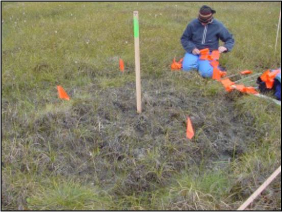
Federal
Arctic Vegetation Plots at Frost Boil Sites, North Slope, Alaska, 2000-2006
National Aeronautics and Space Administration —
This data set describes the environment, soil, and vegetation on nonsorted circles and earth hummocks at seven study sites along a N-S-transect from the Arctic Ocean... -
Federal
Mean Annual Fluxes of Carbon in Coastal Ecosystems of Eastern North America
National Aeronautics and Space Administration —
This dataset contains best estimates and uncertainties for mean annual fluxes of inorganic, organic, and total (organic + inorganic) carbon in tidal wetlands,... -
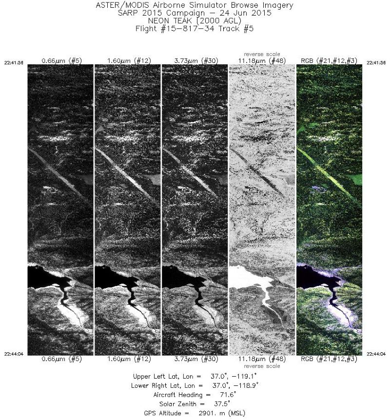
Federal
MASTER: HyspIRI Airborne Campaign, California, Early Spring 2013, V2
National Aeronautics and Space Administration —
This dataset includes Level 1B (L1B) and Level 2 (L2) data products from the MODIS/ASTER Airborne Simulator (MASTER) instrument. The spectral data were collected as... -
Federal
LBA-ECO LC-21 Soil Characteristics, Logged Areas, Tapajos Forest, Para, Brazil: 2003
National Aeronautics and Space Administration —
This data set provides measurements for soil nutrients from areas that were selectively logged and from control areas in the Tapajos National Forest, Para Western... -
Federal
LBA-ECO LC-01 Landsat MSS, TM, ETM+ Imagery, Northern Ecuadorian Amazon: 1973-2002
National Aeronautics and Space Administration —
This data set contains a time series of early Landsat-4 MSS satellite imagery as well as Landsat-5 TM and Landsat-7 ETM+ satellite imagery of the northern Ecuadorian... -
Federal
LBA-ECO CD-06 CO2 Exchange in River Systems Across the Amazon Basin: 2004-2007
National Aeronautics and Space Administration —
This data set provides measurements of carbon dioxide flux rates (FCO2), gas transfer velocity (k), and partial pressures (pCO2) at 75 sites on rivers and streams of... -
Federal
LBA-ECO CD-08 Radiocarbon Dates for Large Trees from a Forest near Manaus, Brazil
National Aeronautics and Space Administration —
This data set reports the ages and growth rates of trees as determined by radiocarbon dating (14C), selected from a logging operation near the city of Itacoatiara,... -
Federal
LBA-ECO CD-04 Soil Moisture Data, km 83 Tower Site, Tapajos National Forest, Brazil
National Aeronautics and Space Administration —
This data set reports continuous high-resolution frequency-domain reflectometry measurements of soil moisture to 10 m depth and precipitation data near each of the... -
Federal
LBA-ECO CD-10 CO2 Profiles at km 67 Tower Site, Tapajos National Forest
National Aeronautics and Space Administration —
Eddy fluxes of CO2 and H2O are measured at two levels (58m and 47m) using tower-mounted closed-path Licor 6262 analyzers and Campbell CSAT3 sonic anemometers. A third... -
Federal
JERS-1 Synthetic Aperture Radar, 100-m Mosaics, South America: 1995-1996, R1
National Aeronautics and Space Administration —
This data set provides ~100-m resolution image mosaics of South America acquired during the low flood season between September and December 1995 and during the high... -
Federal
Delta-X: In Situ Water Quality Indicators across MRD, LA, USA, 2021, Version 2
National Aeronautics and Space Administration —
This dataset provides in situ measurements of water temperature (degrees C), salinity (PSU), turbidity (FNU), and chlorophyll-a fluorescence (RFU) in surface of the... -
Federal
ABoVE: Soil Temperature Profiles, USArray Seismic Stations, AK and Canada, 2016-2019
National Aeronautics and Space Administration —
This dataset includes soil temperature profile measurements taken at 16 monitoring sites in Alaska, USA, and at one site in Yukon, Canada. The six sites are... -
Federal
ABoVE: Post-Fire and Unburned Vegetation Community and Field Data, NWT, Canada, 2019
National Aeronautics and Space Administration —
This dataset provides vegetation community characteristics, soil moisture, and biophysical data collected in 2019 from 11 study areas, which contained 28 sites that... -
Federal
Site Averaged Neutron Soil Moisture: 1987 (Betts)
National Aeronautics and Space Administration —
The Site Averaged Neutron Soil Moisture Data: 1987 (Betts) Data Set contains the site averaged product data of the neutron probe soil moisture collected during the... -
Federal
RSS CCMP Monthly 10 Meter Surface Winds Level 4 Version 3.1
National Aeronautics and Space Administration —
This data set contains a monthly-mean, 0.25 degree resolution, near-global gridded analysis of ocean surface winds (wind speed, components, and anomalies) from the... -
Federal
Optical Thickness Data: Staff (FIFE)
National Aeronautics and Space Administration —
Aerosol optical thickness in conjunction with an atmospheric model can provide estimates of atmospheric effects on transmitted and reflected solar radiation. These...

Official websites use .gov
A
.gov website belongs to an official government
organization in the United States.
Secure .gov websites use HTTPS
A
lock (
) or https:// means you’ve safely connected to
the .gov website. Share sensitive information only on official,
secure websites.