
-
Federal
ISLSCP II Globalview: Atmospheric CO2 Concentrations
National Aeronautics and Space Administration —
The GlobalView Carbon Dioxide (CO2) data product contains synchronized and smoothed time series of atmospheric CO2 concentrations at selected sites that were created... -
Federal
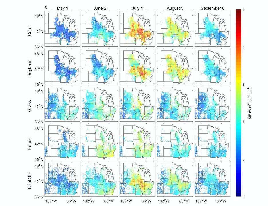
High Resolution Land Cover-Specific Solar-Induced Fluorescence, Midwestern USA, 2018
National Aeronautics and Space Administration —
This dataset provides estimated solar-induced chlorophyll fluorescence (SIF) of specific vegetation types and total SIF under clear-sky and real/cloudy conditions at... -
Federal
CARVE: L1 Daily Flight Path Geolocation and Aircraft Position Data, Alaska, 2012-2015
National Aeronautics and Space Administration —
This data set provides high-frequency geolocation, time, height, pitch, roll, and heading information for the C-23 Sherpa aircraft during airborne campaigns over the... -
Federal
BOREAS HYD-04 Standard Snow Course Data
National Aeronautics and Space Administration —
The BOREAS HYD-04 work was focused on collecting data during the winter field campaign (FFC-W) to improve the understanding of winter processes within the boreal... -
Federal
Data over the SSA in Raster Format and AEAC Projection
National Aeronautics and Space Administration —
This data set consists of GIS layers that describe the soils of the BOREAS SSA. The original data were submitted as vector layers that were gridded by BOREAS staff to... -
Federal
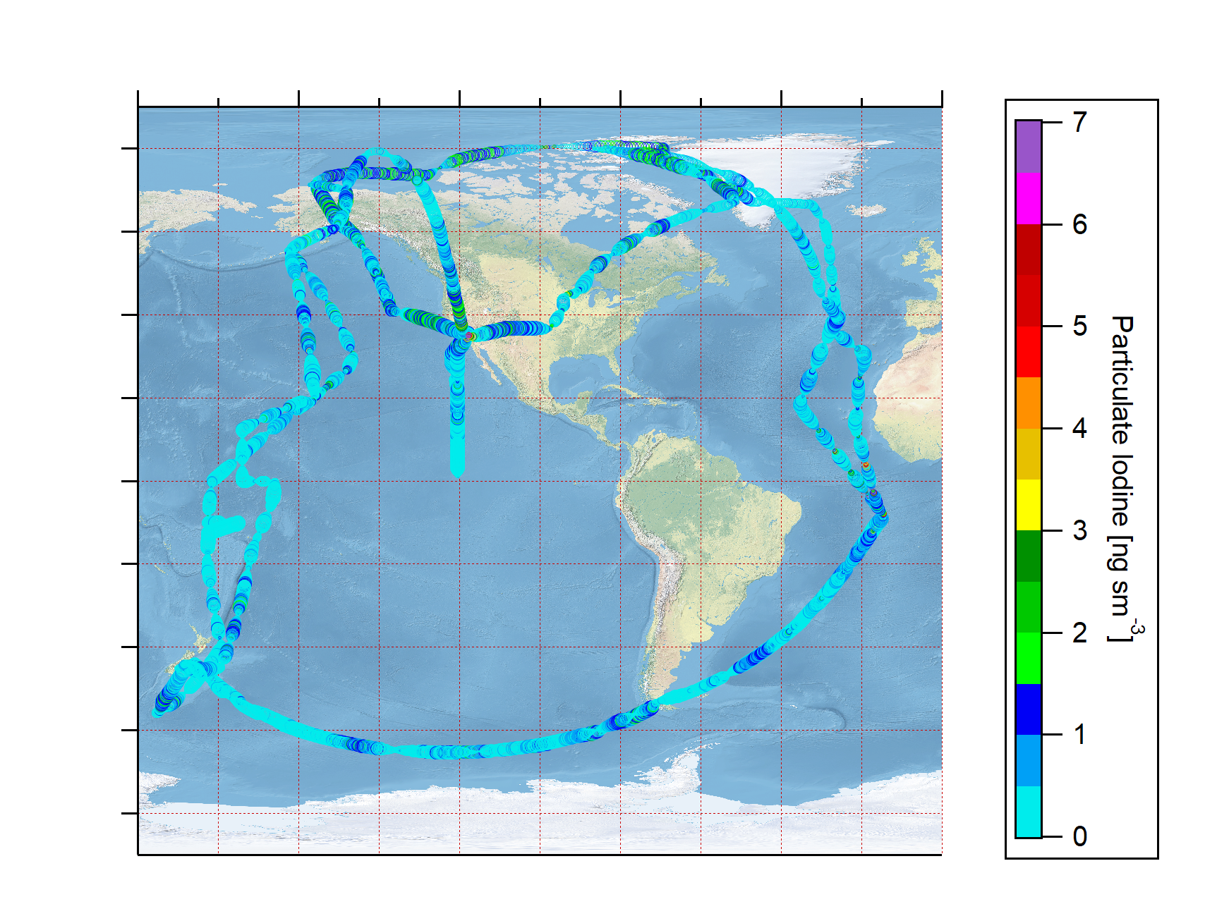
ATom: L2 Particulate Iodine from High-Resolution Aerosol Mass Spectrometer (HR-AMS)
National Aeronautics and Space Administration —
This dataset provides mass concentrations of particulate iodine as measured by the High-Resolution Aerosol Mass Spectrometer (HR-AMS) during the first two deployments... -
Federal
AVIRIS-Classic: L1B Calibrated Radiance, Facility Instrument Collection, V1
National Aeronautics and Space Administration —
This dataset contains Level 1B (L1B) orthocorrected, scaled radiance image files as well as files of observational geometry and illumination parameters and supporting... -
Federal
ABoVE: Burn Severity of Soil Organic Matter, Northwest Territories, Canada, 2014-2015
National Aeronautics and Space Administration —
This dataset provides maps at 30-m resolution of landscape surface burn severity (surface litter and soil organic layers) from the 2014-2015 fires in the Northwest... -
Federal
ACT-America: L1 Raw, Uncalibrated In-Situ CO2, CO, and CH4 Mole Fractions from Towers
National Aeronautics and Space Administration —
This dataset provides Level 1 (L1) in situ atmospheric carbon dioxide (CO2), carbon monoxide (CO), and methane (CH4) concentrations as measured on a network of... -
Federal
ABoVE: Soil Temperature Profiles, USArray Seismic Stations, AK and Canada, 2016-2019
National Aeronautics and Space Administration —
This dataset includes soil temperature profile measurements taken at 16 monitoring sites in Alaska, USA, and at one site in Yukon, Canada. The six sites are... -
Federal
FIFE CDROM Vol. 3 Contents: NS001 Thematic Mapper Simulator (TMS) Imagery, 1987-1989
National Aeronautics and Space Administration —
This data set provides aircraft-based NS001 Thematic Mapper Simulator (TMS) images of the study area associated with The First ISLSCP (International Satellite Land... -
Federal
Calculated Leaf Carbon and Nitrogen, 1992 (ACCP)
National Aeronautics and Space Administration —
The purpose of these measurements was to determine plot-level average leaf concentrations of nitrogen, lignin, cellulose, etc. in order to investigate how AVIRIS... -
Federal
MASTER: Airborne Science, California-Nevada, August, 2004
National Aeronautics and Space Administration —
This dataset includes Level 1B (L1B) data products from the MODIS/ASTER Airborne Simulator (MASTER) instrument. The spectral data were collected during one flight... -
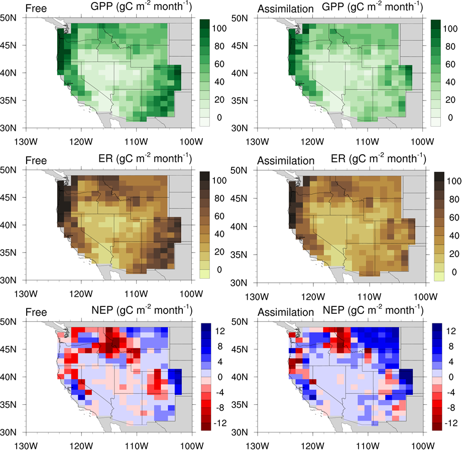
Federal
CLM5-DART Regional Carbon Fluxes and Stocks over the Western US, 1998-2010
National Aeronautics and Space Administration —
This dataset provides monthly estimates of biomass stocks and land-atmosphere carbon exchange across the western United States at 0.95 degrees longitude x 1.25... -
Federal
BOREAS TE-18 Landsat TM Physical Classification Image of the NSA
National Aeronautics and Space Administration —
The objective of this classification is to provide the BOREAS investigators with a data product that characterizes the land cover of the NSA. A Landsat-5 TM image... -
Federal
BOREAS RSS-19 1994 CASI At-Sensor Radiance and Reflectance Images
National Aeronautics and Space Administration —
The RSS-19 team collected CASI images from the Chieftain Navaho aircraft in order to observe the seasonal change in the radiometric reflectance properties of the... -
Federal
BOREAS TE-05 Surface Meteorological & Radiation Data
National Aeronautics and Space Administration —
The BOREAS group TE-05 collected measurements in the NSA and SSA on gas exchange, gas composition and tree growth. Measurements of meteorological data, including air... -
Federal
AirMOSS: L1 S-0 Polarimetric Data from AirMOSS P-band SAR, MOISST, 2012-2015
National Aeronautics and Space Administration —
This data set provides level 1 (L1) polarimetric radar backscattering coefficient (sigma-0), multilook complex, polarimetrically calibrated, and georeferenced data...

Official websites use .gov
A
.gov website belongs to an official government
organization in the United States.
Secure .gov websites use HTTPS
A
lock (
) or https:// means you’ve safely connected to
the .gov website. Share sensitive information only on official,
secure websites.