
-
Federal
South Experimental Oculina Research Reserve, Oculina Banks Clelia Dive 610 Narrative 2001 - Videotape and Visual Observations from Submersible Dives to the Oculina Banks Deep Sea Coral Reefs (NODC Accession 0047190)
National Oceanic and Atmospheric Administration, Department of Commerce —
The data presented in the Oculina Banks Geographic Information System (OGIS) were collected as part of a cooperative project between: the National Oceanographic and... -
Federal
Scleratinian percent cover for Florida Keys National Marine Sanctuary, from 1999-2009 (NODC Accession 0123059)
National Oceanic and Atmospheric Administration, Department of Commerce —
This dataset contains records of scleractinian coral cover compiled from multiple sources. These are: CREMP, SCREAM, and CCFHR. CREMP: Coral Reef Evaluation and... -
Federal
SEAKEYS - Fowey Rocks 2006 Meteorological and Oceanographic Observations (NODC Accession 0058100)
National Oceanic and Atmospheric Administration, Department of Commerce —
The Florida Institute of Oceanography's (FIO) SEAKEYS (Sustained Ecological Research Related to Management of the Florida Keys Seascape) program began in 1989 and has... -
Federal
2006 Multibeam Mapping of along-shelf corridor, between Madison-Swanson and Steamboat Lumps Florida
National Oceanic and Atmospheric Administration, Department of Commerce —
This disk or set of disks contain high-resolution multibeam and backscatter maps of a long thin corridor at the shelf edge near he 74-m isobath spanning from Madison-... -
Federal
NOAA TIFF Image - 10m Multibeam Bathymetry, South Atlantic Bight - Deep Coral Priority Areas - NOAA Ship Nancy Foster - (2010), UTM 17N NAD83
National Oceanic and Atmospheric Administration, Department of Commerce —
This dataset contains a unified GeoTiff with 10x10 meter cell size representing the bathymetry of several deep coral priority areas off the South Atlantic Bight,... -
Federal
SEAKEYS - Long Key 2007 Meteorological and Oceanographic Observations (NODC Accession 0058101)
National Oceanic and Atmospheric Administration, Department of Commerce —
The Florida Institute of Oceanography's (FIO) SEAKEYS (Sustained Ecological Research Related to Management of the Florida Keys Seascape) program began in 1989 and has... -
Federal
NOAA TIFF Image - 30m Multibeam Bathymetry, South Atlantic Bight - Deep Coral Priority Areas - Navy Pathfinder - (2003), UTM 17N NAD83
National Oceanic and Atmospheric Administration, Department of Commerce —
This dataset contains a unified GeoTiff with 30x30 meter cell size representing the bathymetry of several deep coral priority areas off the South Atlantic Bight,... -
Federal
FL Straights CICESE Mooring EFL5-T1030-SBE56-NS03440-Z130 (20140709-20150711)
National Oceanic and Atmospheric Administration, Department of Commerce —
Data for Florida Straights Moorings CICESE. A program aimed at measuring the flows between the Gulf of Mexico and the North Atlantic Ocean, from Cuba to Florida,... -
Federal
FLKEYS Array, Station HFA18, Bottom Temperature
National Oceanic and Atmospheric Administration, Department of Commerce —
Timeseries data from 'FLKEYS Array, Station HFA18, Bottom Temperature' (org_secoora_flkeys_hfa18) -
Federal
FL Straights CICESE Mooring EFL7-T180-A3L-NS3591-Z171 (20150711-20160812)
National Oceanic and Atmospheric Administration, Department of Commerce —
Data for Florida Straights Moorings CICESE. A program aimed at measuring the flows between the Gulf of Mexico and the North Atlantic Ocean, from Cuba to Florida,... -
Federal
usf-gansett-20211110T1200
National Oceanic and Atmospheric Administration, Department of Commerce —
The purpose of this deployment is to collect water column variables to understand biological and physical processes to understand the dynamics and potential for the... -
Federal
TEQ Array, Station LWNO, Bottom Temperature
National Oceanic and Atmospheric Administration, Department of Commerce —
Timeseries data from 'TEQ Array, Station LWNO, Bottom Temperature' (org_secoora_teq_lwno) -
Federal
Station 22.5, South Florida Program Survey Cruises
National Oceanic and Atmospheric Administration, Department of Commerce —
Timeseries data from 'Station 22.5, South Florida Program Survey Cruises' (station-22-5-south-florida-progr) -
Federal
Station CH4, South Florida Program Survey Cruises
National Oceanic and Atmospheric Administration, Department of Commerce —
Timeseries data from 'Station CH4, South Florida Program Survey Cruises' (station-ch4-south-florida-progra) -
Federal
TEQ Array, Station 10BR, Bottom Temperature
National Oceanic and Atmospheric Administration, Department of Commerce —
Timeseries data from 'TEQ Array, Station 10BR, Bottom Temperature' (org_secoora_teq_10br) -
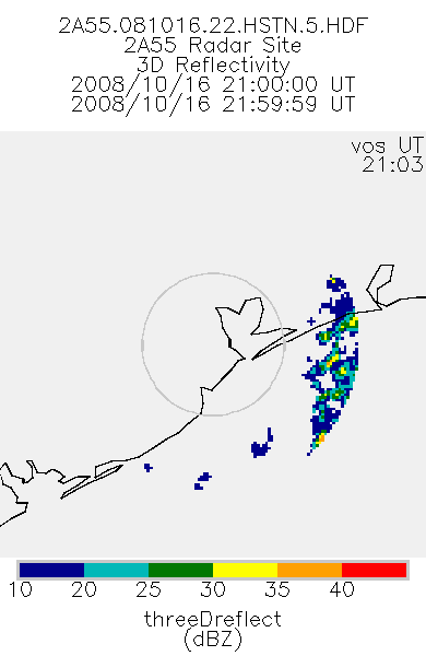
Federal
TRMM Ground Validation Radar Site 3D Reflectivity L2 1 hour V7 (TRMM_2A55) at GES DISC
National Aeronautics and Space Administration —
'Radar Site 3-D Reflectivities', is composed of 3 different fields. The first field has an array of 3-D reflectivities in Cartesian coordinates with a 2 km horizontal... -
Federal
Portable Remote Imaging Spectrometer (PRISM) COral Reef Airborne Laboratory (CORAL) Regional Reflectance Data
National Aeronautics and Space Administration —
Flight line reflectance measurements from the Portable Remote Imaging Spectrometer (PRISM) instrument aboard the Tempus Applied Solutions Gulfstream-IV (G-IV)...

Official websites use .gov
A
.gov website belongs to an official government
organization in the United States.
Secure .gov websites use HTTPS
A
lock (
) or https:// means you’ve safely connected to
the .gov website. Share sensitive information only on official,
secure websites.