

75 datasets found
-
Federal
SEAC4RS Analysis and Ancillary Data recent views
National Aeronautics and Space Administration —
SEAC4RS_Analysis_Data are ancillary analysis data utilized as part of the Studies of Emissions and Atmospheric Composition, Clouds and Climate Coupling by Regional... -
Federal
HURRICANE AND SEVERE STORM SENTINEL (HS3) HIGH-ALTITUDE IMAGING WIND AND RAIN AIRBORNE PROFILER (HIWRAP) V1 recent views
National Aeronautics and Space Administration —
The Hurricane and Severe Storm Sentinel (HS3) High-Altitude Imaging Wind and Rain dataset was collected from the High-altitude Imaging Wind and Rain Airborne Profiler... -
Federal
HURRICANE AND SEVERE STORM SENTINEL (HS3) FLIGHT REPORTS V1 recent views
National Aeronautics and Space Administration —
The Hurricane and Severe Storm Sentinel (HS3) Flight Reports provide information about flights flown by the WB-57 and Global Hawk aircrafts during the Hurricane and... -
Federal
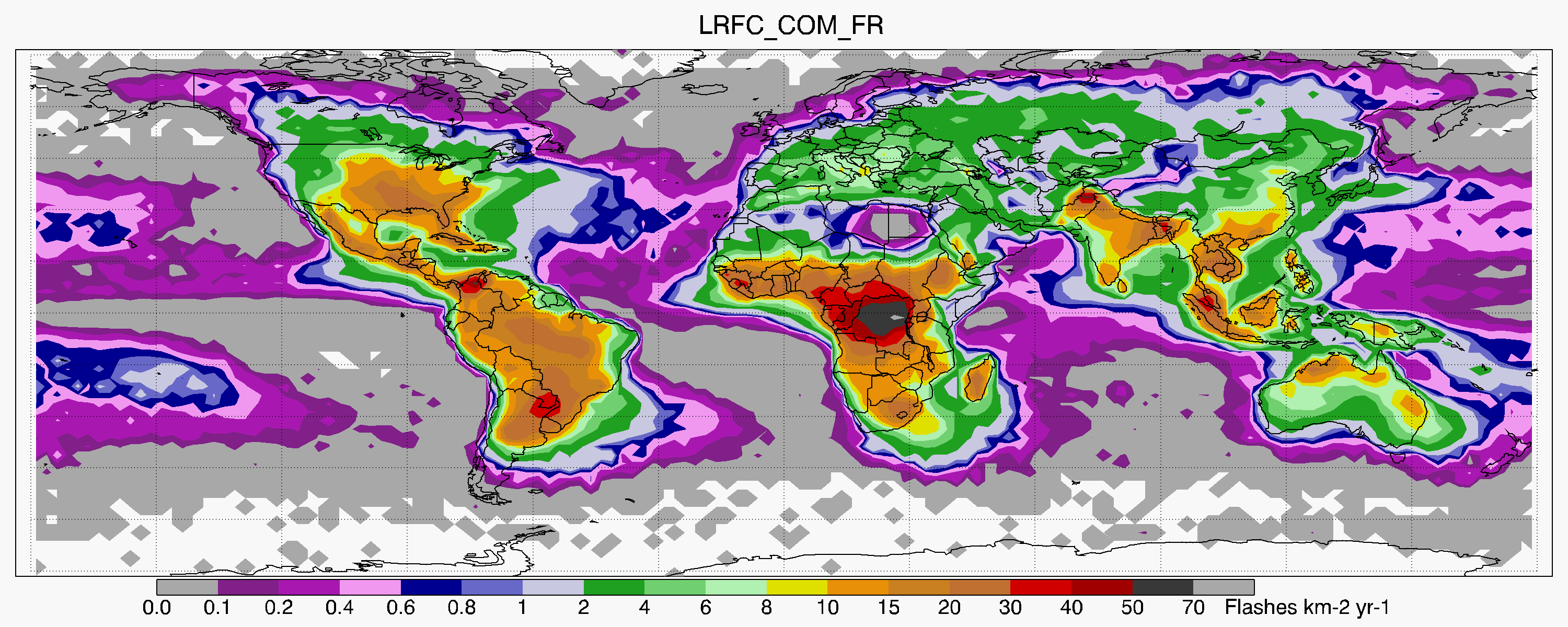
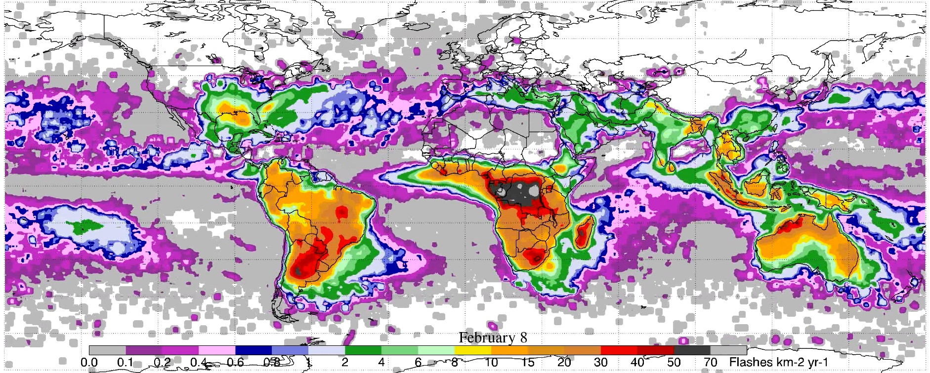
LIS/OTD 2.5 Degree Low Resolution Full Climatology (LRFC) V2.3.2015 recent views
National Aeronautics and Space Administration —
The LIS/OTD 2.5 Degree Low Resolution Full Climatology (LRFC) contains a variety of gridded climatologies of total lightning flash rates obtained from two lightning... -
Federal
HURRICANE AND SEVERE STORM SENTINEL (HS3) WORLD WIDE LIGHTNING LOCATION NETWORK (WWLLN) STORMS V1 recent views
National Aeronautics and Space Administration —
The World Wide Lightning Location Network (WWLLN) is a global, ground-based lightning sensor network operated by the University of Washington in Seattle. This network... -
Federal
HURRICANE AND SEVERE STORM SENTINEL (HS3) GLOBAL HAWK NAVIGATION V1 recent views
National Aeronautics and Space Administration —
The Hurricane and Severe Storm Sentinel (HS3) Global Hawk Navigation dataset consists of the real-time navigation and housekeeping data that was acquired from various... -
Federal
Global Monthly Climatology for the Twentieth Century (New et al.) recent views
National Aeronautics and Space Administration —
A 0.5 degree lat/lon data set of monthly surface climate over global land areas, excluding Antarctica. Primary variables are interpolated directly from station time-... -
Federal
LIS/OTD 0.5 Degree High Resolution Monthly Climatology (HRMC) V2.3.2015 recent views
National Aeronautics and Space Administration —
The LIS/OTD 0.5 Degree High Resolution Monthly Climatology (HRMC) contains a variety of gridded climatologies of total lightning flash rates obtained from two... -
Federal
Dynamics and Chemistry of the Summer Stratosphere Radar and Satellite (Remote Sensing) Data Products recent views
National Aeronautics and Space Administration —
DCOTSS-Radar-Satellite-Data feature the radar and satellite data products for the Dynamics and Chemistry of the Summer Stratosphere sub-orbital campaign. Featured in... -
Federal
GOES-R PLT Geostationary Coastal and Air Pollution Event (GEO-CAPE) Airborne Simulator (GCAS) V1 recent views
National Aeronautics and Space Administration —
The GOES-R PLT Geostationary Coastal and Air Pollution Event (GEO-CAPE) Airborne Simulator (GCAS) dataset consist of solar backscattered radiation measured by the... -
Federal
Global 30-Year Mean Monthly Climatology, 1901-1960 (New et al.) recent views
National Aeronautics and Space Administration —
A data set of 30-year mean monthly surface climate over global land areas, excluding Antarctica. Interpolated from station data to 0.5 degree lat/lon for a range of... -
Federal
GPM GROUND VALIDATION MISSION REPORTS GCPEX V1 recent views
National Aeronautics and Space Administration —
The GPM Ground Validation Mission Reports GCPEx dataset consists of various reports filed by the scientists during the GPM Cold-season Precipitation Experiment... -
Federal
GPM GROUND VALIDATION CAMPAIGN REPORTS IFLOODS V1 recent views
National Aeronautics and Space Administration —
The GPM Ground Validation Campaign Reports IFloodS dataset consists of various reports filed by the scientists during the GPM Ground Validation Iowa Flood Studies... -
Federal
LBA-ECO CD-05 Understory Fuel Stick Moisture, km 67 Site, Para, Brazil: 1998-2000 recent views
National Aeronautics and Space Administration —
This data set contains moisture content measurements for fuel sticks located in the forest understory of the rainfall exclusion experimental site, Tapajos National... -
Federal
Climate Impact Meteorological Stations (CLIM-MET) data from Canyonlands National Park, Utah recent views
Department of the Interior —
These CLIM-MET stations are meteorological/geological stations that is designed to function in remote areas for long periods of time without human intervention. These...
75 datasets found