
-
Federal
Cloudmask, CLAVR-1, NOAA POES AVHRR, 0.0125 degrees, West US, 2007-present, Daytime (Single Scan)
National Oceanic and Atmospheric Administration, Department of Commerce —
The CLAVR-1 cloudmask (Stowe, 1999) is used to cloudmask AVHRR high resolution sea surface temperature products. The cloudmask runs a series of tests on each surface... -
Federal
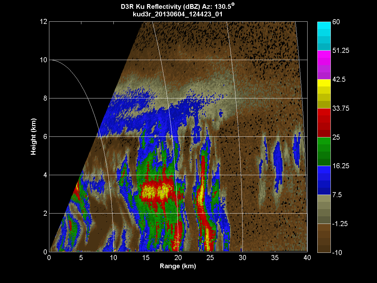
GPM GROUND VALIDATION DUAL-FREQUENCY DUAL-POLARIZED DOPPLER RADAR (D3R) IFLOODS V1
National Aeronautics and Space Administration —
The GPM Ground Validation Dual-frequency Dual-polarized Doppler Radar (D3R) IFloodS dataset contains radar reflectivity and doppler velocity measurements from the... -
Federal
SatCORPS CERES GEO Edition 4 Meteosat-9 Northern Hemisphere Version 1.0
National Aeronautics and Space Administration —
CER_GEO_Ed4_MET09_NH_V01 is the Satellite Cloud and Radiation Property retrieval System (SatCORPS) Clouds and the Earth's Radiant Energy System (CERES) Geostationary... -
Federal
SWOT Level 2 Radiometer Brightness Temperatures and Troposphere Interim Data Product Version 1.0
National Aeronautics and Space Administration —
The SWOT Level 2 Radiometer Brightness Temperatures and Troposphere Interim Geophysical Data Record (IGDR) Version 1.0 dataset produced by the Surface Water and Ocean... -
Federal
NCEP-GTS Marine Observations in IMMA format
National Oceanic and Atmospheric Administration, Department of Commerce —
The Global Telecommunications System (GTS) is a major component of transmitting global meteorological data, consisting of both in situ and satellite observations.... -
Federal
NOAA GOES-R Series Advanced Baseline Imager (ABI) Level 2 Cloud Top Pressure (CTP)
National Oceanic and Atmospheric Administration, Department of Commerce —
The Advanced Baseline Imager (ABI) Cloud Top Pressure product contains an image with pixel values identifying the atmospheric pressure at the top of a cloud layer.... -
Federal
WDC-A Meteorological and Oceanographic Data from Chernobyl for 1986
National Oceanic and Atmospheric Administration, Department of Commerce —
WDCA Chernobyl Data consists of digital data set DSI-9681, archived at the National Centers for Environmental Information (NCEI). World Data Center for Meteorology... -
Federal
Cape Kennedy Thunderstorms Data
National Oceanic and Atmospheric Administration, Department of Commerce —
Cape Kennedy Thunderstorms Data contains an account of all thunderstorms reported in weather observations taken at Cape Kennedy Air Force Station, Florida between... -
Federal
SatCORPS CERES GEO Edition 4 GOES-13 Southern Hemisphere Version 1.0
National Aeronautics and Space Administration —
CER_GEO_Ed4_GOE13_SH_V01 is the Satellite Cloud and Radiation Property retrieval System (SatCORPS) Clouds and the Earth's Radiant Energy System (CERES) Geostationary... -
Federal
TOVS GLA DAILY GRIDS from TIROSN V01 (TOVSADTN) at GES DISC
National Aeronautics and Space Administration —
This dataset (TOVSADTN) contains the TIROS Operational Vertical Sounder (TOVS) level 3 geophysical parameters derived using data from TIROS-N and the physical... -
Federal
NOAA GOES-R Series Advanced Baseline Imager (ABI) Level 2 Derived Motion Winds (DMW)
National Oceanic and Atmospheric Administration, Department of Commerce —
The GOES-R Advanced Baseline Imager (ABI) Derived Motion Winds product contains a list of wind vectors identifying their location, wind speed, wind direction, air... -
Federal
International Comprehensive Ocean-Atmosphere Data Set (ICOADS) Near-Real-Time (NRT) Release 3.0.2, 2015 to Present
National Oceanic and Atmospheric Administration, Department of Commerce —
The International Comprehensive Ocean-Atmosphere Data Set (ICOADS) Near-Real-Time (NRT) product has been updated to a new version, Release 3.0.2. The new version... -
Federal
ATLAS/ICESat-2 L3B Weekly Gridded Atmosphere V005
National Aeronautics and Space Administration —
This product reports weekly global cloud fraction, total column optical depth over the oceans, polar cloud fraction, blowing snow frequency, apparent surface... -
Federal
GLAS/ICESat L2 Global Thin Cloud/Aerosol Optical Depths Data (HDF5) V033
National Aeronautics and Space Administration —
GLAH11 Level-2 thin cloud/aerosol optical depths data contain thin cloud and aerosol optical depths. A thin cloud is one that does not completely attenuate the lidar... -
Federal
TES/Aura L2 Methanol Nadir V007
National Aeronautics and Space Administration —
TL2MTLN_7 is the Tropospheric Emission Spectrometer (TES)/Aura Level 2 Methanol Nadir Version 7 data product. TES was an instrument aboard NASA's Aura satellite and... -
Federal
US Voluntary Observing Ship (VOS) - International Maritime Meteorological Tape (IMMT) data from TurboWin version 5.0 E-Logbook Software
National Oceanic and Atmospheric Administration, Department of Commerce —
The US Voluntary Observing Ships (VOS) report surface marine observations in both real-time (FM-13 ship format) and delayed-mode (International Maritime... -
Federal
TOVS GLA 5 DAY GRIDS from NOAA-12 V01 (TOVSA5ND) at GES DISC
National Aeronautics and Space Administration —
This dataset (TOVSA5ND) contains the TIROS Operational Vertical Sounder (TOVS) level 3 geophysical parameters derived using data from NOAA-12 and the physical... -
Federal
TRMM Microwave Imager Hydrometeor Profile L2 1.5 hours V7 (TRMM_2A12) at GES DISC
National Aeronautics and Space Administration —
The new version of these data is in GPM-like format and can be found under the name GPM_2AGPROFTRMMTMI_CLIM. This dataset, 2A12, ”TMI Profiling”, generates surface... -
Federal
NASA/GEWEX Surface Radiation Budget (SRB) Data and Info
National Aeronautics and Space Administration —
The NASA/GEWEX Surface Radiation Budget (SRB) Release-3.0 data sets contains global 3-hourly, daily, monthly/3-hourly, and monthly averages of surface and top-of... -
Federal
TOVS GLA 5 DAY GRIDS from TIROSN V01 (TOVSA5TN ) at GES DISC
National Aeronautics and Space Administration —
This dataset (TOVSA5TN) contains the TIROS Operational Vertical Sounder (TOVS) level 3 geophysical parameters derived using data from TIROS-N and the physical...

Official websites use .gov
A
.gov website belongs to an official government
organization in the United States.
Secure .gov websites use HTTPS
A
lock (
) or https:// means you’ve safely connected to
the .gov website. Share sensitive information only on official,
secure websites.