
-
Federal
PlanetScope Satellite Imagery 3 Band Scene
National Aeronautics and Space Administration —
The Planet Scope 3 band collection contains satellite imagery obtained from Planet Labs, Inc by the Commercial SmallSat Data Acquisition (CSDA) Program. This... -
Federal
CERES Single Scanner Footprint (SSF) TOA/Surface Fluxes, Clouds and Aerosols Aqua-FM3 Edition4A
National Aeronautics and Space Administration —
CER_SSF_Aqua-FM3-MODIS_Edition4A is the Clouds and the Earth's Radiant Energy System (CERES) Single Scanner Footprint (SSF) Top-of-the-Atmosphere (TOA)/Surface... -
Federal
WorldView-2 Level 1B Panchromatic Satellite Imagery
National Aeronautics and Space Administration —
The WorldView-2 Level 1B Panchromatic Imagery collection contains satellite imagery acquired from Maxar Technologies (formerly known as DigitalGlobe) by the... -
Federal
TROPESS CrIS-SNPP L2 for Delhi Megacity, Summary Product V1 (TRPSYL2ALLCRSMGDEL) at GES DISC
National Aeronautics and Space Administration —
The TROPESS CrIS-SNPP L2 for Delhi Megacity, Summary Product contains the vertical distribution of six retrieved atmospheric gases (CH4, CO, HDO, NH3, O3 and PAN),... -
Federal
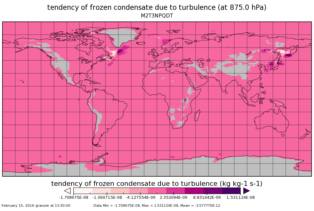
MERRA-2 tavg3_3d_qdt_Np: 3d,3-Hourly,Time-Averaged,Pressure-Level,Assimilation,Moist Tendencies 0.625 x 0.5 degree V5.12.4 (M2T3NPQDT) at GES DISC
National Aeronautics and Space Administration —
M2T3NPQDT (or tavg3_3d_qdt_Np) is a 3-dimensional 3-hourly time averaged data collection in Modern-Era Retrospective analysis for Research and Applications version 2... -
Federal
Radiant Temp. Multiangle Data (FIFE)
National Aeronautics and Space Administration —
The Surface Temperatures Measured at Multiple Angles Data Set was collected at two locations within the northwest quadrant of the FIFE study area during July and... -
Federal
BOREAS TF-11 CO2 and CH4 Flux Data from the SSA-Fen
National Aeronautics and Space Administration —
The BOREAS TF-11 team collected several data sets in their efforts to fully describe the flux and site characteristics at the SSA-Fen site. This data set contains... -
Federal
MISR Level 3 Component Global Land Regional public Product covering a month V002
National Aeronautics and Space Administration —
MI3MLSR_2 is the Multi-angle Imaging SpectroRadiometer (MISR) Level 3 Component Global Land Regional public Product covering a month version 2. It contains a daily... -
Federal
First ISCCP Regional Experiment (FIRE) Atlantic Stratocumulus Transition Experiment (ASTEX) ISCCP DX Cloud Product - Revised Algorithm Data
National Aeronautics and Space Administration —
The First ISCCP Regional Experiments (FIRE) have been designed to improve data products and cloud/radiation parameterizations used in general circulation models... -
Federal
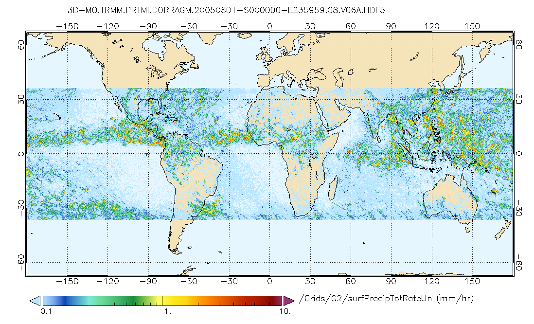
GPM PR and TMI on TRMM (Combined Precipitation) L3 1 month 0.25x0.25 degree V07 (GPM_3CMB_TRMM) at GES DISC
National Aeronautics and Space Administration —
This is the new (GPM-formated) TRMM Combined product, using the GPM algorithms, for the TRMM epoch (December 1997 - April 2015). It replaces the old TRMM_3B31 This is... -
Federal
Norwegian North Polar Expedition 1893-1896: Oceanographic Data, Version 1
National Aeronautics and Space Administration —
This data set contains water depth, temperature, specific gravity, salinity, and density measurements from the North Polar Basin and the Barents Sea, gathered by... -
Federal
LIMS/Nimbus-7 Level 2 Vertical Profiles of O3, NO2, H2O, HNO3, Geopotential Height, and Temperature V006 (LIMSN7L2) at GES DISC
National Aeronautics and Space Administration —
The Limb Infrared Monitor of the Stratosphere (LIMS) version 6 Level-2 data product consists of daily, geolocated, vertical profiles of temperature, geopotential... -
Federal
ECCO Global Mean Atmospheric Pressure - Snapshot (Version 4 Release 4)
National Aeronautics and Space Administration —
This dataset provides instantaneous hourly global mean atmospheric pressure from the ECCO Version 4 Release 4 (V4r4) ocean and sea-ice state estimate. Estimating the... -
Federal
BOREAS TGB-01 CH4 Concentration and Flux Data from NSA Tower Sites
National Aeronautics and Space Administration —
The BOREAS TGB-01 team made numerous measurements of trace gas concentrations and fluxes at various NSA sites. This data set contains half-hourly averages of ambient... -
Federal
GEDI L4A Footprint Level Aboveground Biomass Density, Version 2.1
National Aeronautics and Space Administration —
This dataset contains Global Ecosystem Dynamics Investigation (GEDI) Level 4A (L4A) Version 2 predictions of the aboveground biomass density (AGBD; in Mg/ha) and... -
Federal
CERES and GEO-Enhanced TOA, Within-Atmosphere and Surface Fluxes, Clouds and Aerosols Monthly-Averaged 1-Hourly Terra-Aqua-NOAA20 Edition4B
National Aeronautics and Space Administration —
CER_SYN1deg-MHour_Terra-Aqua-NOAA20_Edition4B is the Clouds and the Earth's Radiant Energy System (CERES) and geostationary (GEO)-Enhanced Top-of-Atmosphere (TOA),... -
Federal
SWOT Level 2 Lake Single-Pass Vector Obs Data Product, Version D
National Aeronautics and Space Administration —
The SWOT Level 2 Lake Single-Pass Vector Product (SWOT_L2_HR_LakeSP_D) provides geolocated surface water measurements for lakes and unclassified water bodies, derived... -
Federal
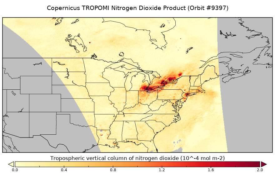
Sentinel-5P TROPOMI Tropospheric NO2 1-Orbit L2 5.5km x 3.5km V2 (S5P_L2__NO2____HiR) at GES DISC
National Aeronautics and Space Administration —
Starting from August 6th in 2019, Sentinel-5P TROPOMI along-track high spatial resolution (~5.5km at nadir) has been implemented. For data before August 6th of 2019,... -
Federal
MODIS/Aqua Aerosol 5-Min L2 Swath Subset 10km along MLS V002 (MAM04S0) at GES DISC
National Aeronautics and Space Administration —
This is the MODIS/Aqua subset along MLS field of view track. The goal of the subset is to select and return MODIS data that are within +-100 km across the MLS track.... -
Federal
ALOS PALSAR Level 1.1 Product
National Aeronautics and Space Administration —
ALOS PALSAR Level 1.1

Official websites use .gov
A
.gov website belongs to an official government
organization in the United States.
Secure .gov websites use HTTPS
A
lock (
) or https:// means you’ve safely connected to
the .gov website. Share sensitive information only on official,
secure websites.