
-
Federal
GEOS-Carb CASA-GFED Daily Fire and Fuel Emissions 0.5 degree x 0.5 degree V3 (GEOS_CASAGFED_D_FIRE) at GES DISC
National Aeronautics and Space Administration —
This product provides Daily average wildfire emissions (FIRE) andfuel wood burning emissions (FUEL) derived from the Carnegie-Ames-Stanford-Approach – Global Fire... -
Federal
Rooftop Energy Potential of Low Income Communities in America REPLICA
Department of Energy —
The Rooftop Energy Potential of Low Income Communities in America REPLICA data set provides estimates of residential rooftop solar technical potential at the tract-... -
Federal
DEPRECATED - Sharing the Sun Community Solar Project Data (December 2021)
Department of Energy —
This data set is no longer current – The most current data and all historical data sets can be found at https://data.nrel.gov/submissions/244 This database represents... -
Federal
ORACLES Trace Gas Aircraft InSitu Data
National Aeronautics and Space Administration —
ORACLES_TraceGas_AircraftInSitu_Data are in situ trace gas measurements collected onboard the P-3 Orion or ER-2 aircraft during the ObseRvations of Aerosols above... -
Federal
GPM IMERG Early Precipitation L3 1 day 0.1 degree x 0.1 degree V07 (GPM_3IMERGDE) at GES DISC
National Aeronautics and Space Administration —
Version 07 is the current version of the data set. Older versions will no longer be available and have been superseded by Version 07.The Integrated Multi-satellitE... -
Federal
Electric Technology Adoption and Energy Consumption
Department of Energy —
Scenario data from the Electrification Futures Study Scenarios of Electric Technology Adoption and Power Consumption for the United States report. Annual projections... -
Federal
GPM SSMIS on F16 (GPROF) Radiometer Precipitation Profiling L2 1.5 hours 12 km V07 (GPM_2AGPROFF16SSMIS) at GES DISC
National Aeronautics and Space Administration —
Version 07 is the current version of the data set. Older versions will no longer be available and have been superseded by Version 07.The 2AGPROF (Goddard Profiling)... -
Federal
MODIS/Aqua+Terra Global Flood Product L3 NRT 250m 2-day GeoTIFF
National Aeronautics and Space Administration —
The MODIS/Aqua+Terra Global Flood Product L3 Near Real Time (NRT) 250m 2-day GeoTIFF Product (MCDWD_L3_F2_NRT) (beta) provides maps of flooding globally. The Global... -
Federal
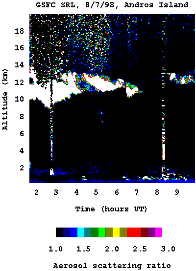
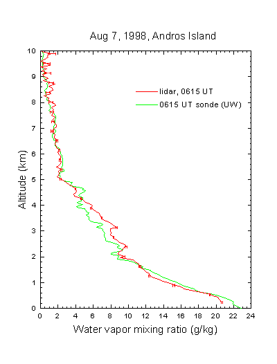
CAMEX-3 SCANNING RAMAN LIDAR V1
National Aeronautics and Space Administration —
The CAMEX-3 Scanning Raman LIDAR dataset collected data during the CAMEX-3 campaign on Andros Island during the period 6 August - 20 September 1998. The SRL... -
Federal
First ISCCP Regional Experiment (FIRE) Cirrus Phase II National Weather Service(NWS) Inner-Network Rawinsonde Data
National Aeronautics and Space Administration —
The First ISCCP Regional Experiments have been designed to improve data products and cloud/radiation parameterizations used in general circulation models (GCMs).... -
Federal
NRAO VLA Sky Survey Catalog
National Aeronautics and Space Administration —
This table contains the National Radio Astronomy Observatory (NRAO) Very Large Array (VLA) Sky Survey, the so-called NVSS Catalog. The NVSS Catalog covers the sky... -
Federal
Puerto Rico Radiosondes CPEX-AW V1
National Aeronautics and Space Administration —
The Puerto Rico Radiosondes CPEX-AW dataset consists of atmospheric pressure, atmospheric temperature, relative humidity, wind speed, and wind direction measurements.... -
Federal
ALOS PALSAR High Resolution Radiometric Terrain Corrected Product
National Aeronautics and Space Administration —
ASF's SAR Radiometric Terrain Corrected (RTC) dataset gives terrestrial world-wide coverage; excluding Antarctica, Greenland, Iceland, and Asia north of 60 degrees... -
Federal
MODIS/Terra Surface Reflectance 8-Day L3 Global 250m SIN Grid V006
National Aeronautics and Space Administration —
The MOD09Q1 Version 6 data product was decommissioned on July 31, 2023. Users are encouraged to use the MOD09Q1 Version 6.1 data product.The MOD09Q1 Version 6 product... -
Federal
WRF-STILT Particle Trajectories for Boston, MA, USA, 2013-2014
National Aeronautics and Space Administration —
This dataset provides Weather Research and Forecasting (WRF) Stochastic Time-Inverted Lagrangian Transport (STILT) particle trajectory data and footprint products for... -
Federal
Optically-Selected QSOS NVSS-Detected Source Catalog
National Aeronautics and Space Administration —
The authors used the 1.4-GHz NRAO VLA Sky Survey (NVSS) to study radio sources in two color-selected QSO samples: a volume-limited sample of 1,313 QSOs defined by Mi... -
Federal
Cygnus-X Catalog
National Aeronautics and Space Administration —
The Cygnus-X project is a Cycle 4 Legacy program (PID 40184) on the Spitzer Space Telescope. The survey imaged a ~24 square degree region centered near 20:30:25,... -
Federal
GOODS-S MIPS 24 micron Photometry Catalog
National Aeronautics and Space Administration —
The Great Observatories Origins Deep Survey (GOODS) aims to unite extremely deep observations from NASA's Great Observatories (Spitzer, Hubble and Chandra), ESA's... -
Federal
Life Cycle Emissions Factors for Electricity Generation Technologies
Department of Energy —
This dataset consists of a table containing the distribution of literature estimates of greenhouse gas emissions for the following electricity generation and storage... -
Federal
Data Publication: Data from NIST IR "Report on VAMAS Round Robin of ISO 13067: Microbeam Analysis - Electron Backscatter Diffraction - Measurement of Average Grain Size"
Department of Commerce —
This data publication includes electron backscatter diffraction (EBSD) data used to support the development of ISO 13067 "Microbeam Analysis - Electron Backscatter...

Official websites use .gov
A
.gov website belongs to an official government
organization in the United States.
Secure .gov websites use HTTPS
A
lock (
) or https:// means you’ve safely connected to
the .gov website. Share sensitive information only on official,
secure websites.