
-
Federal
TIGER/Line Shapefile, 2019, 2010 nation, U.S., 2010 Census Urban Area National
U.S. Census Bureau, Department of Commerce —
The TIGER/Line shapefiles and related database files (.dbf) are an extract of selected geographic and cartographic information from the U.S. Census Bureau's Master... -
Federal
2024 County-Level Hourly Renewable Capacity Factor Dataset for the ReEDS Model
Department of Energy —
This dataset contains hourly capacity factors for each renewable resource class and region (in this case, county). Technologies like large-scale utility PV (UPV),... -
State
Wild Pig Range - CWHR M176 [ds944]
State of California —
Vector datasets of CWHR range maps are one component of California Wildlife Habitat Relationships (CWHR), a comprehensive information system and predictive model for... -
Federal
2022 NSDUH Detailed Tables
U.S. Department of Health & Human Services —
Get detailed national estimates from the 2022 National Survey on Drug Use and Health (NSDUH). The tables provide comprehensive statistics on substance use, mental... -
Federal
NIST Fingerprint Registration and Comparison Tool (NFRaCT)
National Institute of Standards and Technology —
The NIST Fingerprint Registration and Comparison Tool (NFRaCT) is a cross-platform GUI application which allows a user to load a pair of fingerprint images, find... -
City
Louisville Metro KY - Animal Service Intake and Outcome
Louisville Metro Government —
Animal Services Provides for the care and control of animals in the Louisville Metro area, including pet licensing and pet adoption.Data Dictionary:kennel- Location... -
Federal
BLM Natl AIM TerrADat Public Geodatabase
Department of the Interior —
This dataset was created to monitor the status, condition and trend of national BLM resources in accordance with BLM policies. It focuses on the BLM terrestrial core... -
City
Louisville Metro KY - Animal Services Activity Log
Louisville Metro Government —
Animal Services Provides for the care and control of animals in the Louisville Metro area, including pet licensing and pet adoption.Data Dictionary:case number... -
State
MCNA - Population Points with T/D Standards
State of California —
Updated 10/6/2022: In the Time/Distance analysis process, points that were found to have been included initially, but with no significant or year-round population... -
University
GNIS: Populated Places (2013)
Earth Data Analysis Center, University of New Mexico —
The Geographic Names Information System (GNIS) is the Federal standard for geographic nomenclature. The U.S. Geological Survey developed the GNIS for the U.S. Board... -
Federal
Small Area Fair Market Rents (SAFMR) Zip Code Tabulation Areas
Department of Housing and Urban Development —
This feature service outlines relationships between Zip Code Tabulation Areas (ZCTAs) used to denote Small Area Fair Market Rents (SAFMRs) and the Fair Market Rents... -
University
GNIS: Geographic Names Information Systems - All features
Earth Data Analysis Center, University of New Mexico —
The Geographic Names Information System (GNIS) actively seeks data from and partnerships with Government agencies at all levels and other interested organizations.... -
Federal
Human Cell and Tissue Establishment Registration Public Query
U.S. Department of Health & Human Services —
This application provides Human Cell and Tissue registration information for registered, inactive, and pre-registered firms. Query options are by Establishment Name,... -
Census Tracts in 2000
District of Columbia —
The TIGER/Line Files are shapefiles and related database files (.dbf) that are an extract of selected geographic and cartographic information from the U.S. Census... -
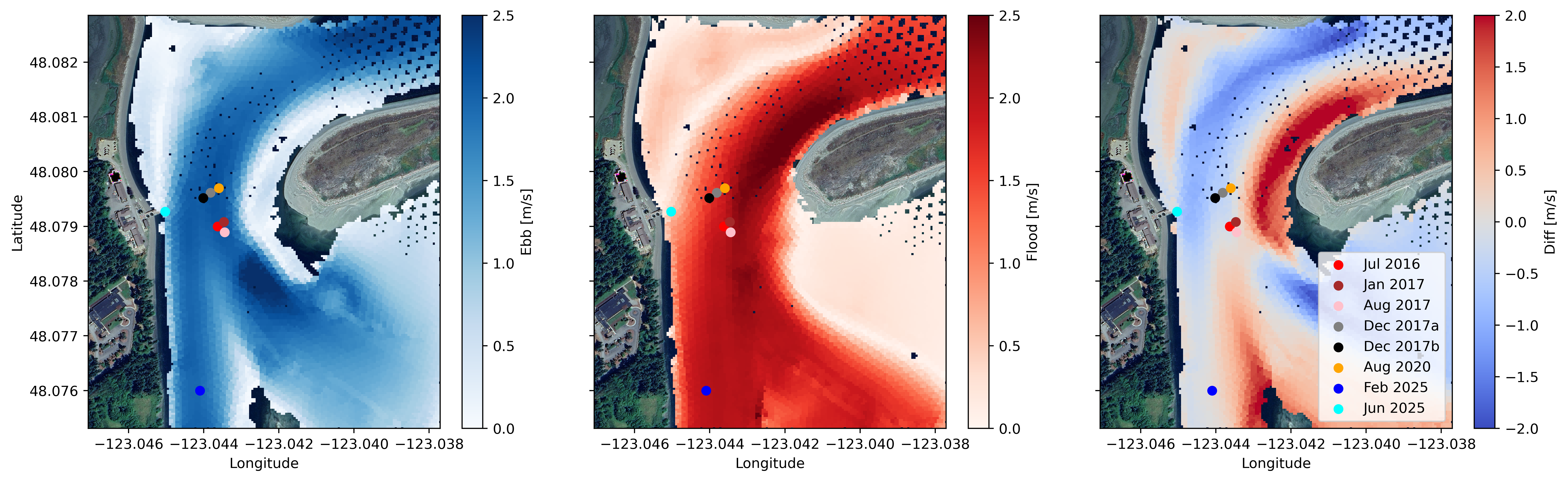
Federal
Water Velocity and Turbulence Data from Sequim Bay, WA, 2016 - 2025
Department of Energy —
Collection of publishable datasets from bottom-lander deployments of acoustic Doppler instrumentation in Sequim Bay, WA measured between 2016 and 2025. These data... -
Federal
2019 NSDUH Detailed Tables
U.S. Department of Health & Human Services —
Get detailed national estimates from the 2018 and 2019 National Surveys on Drug Use and Health (NSDUH). The tables provide comprehensive statistics on substance use,... -
County
Allegheny County Dog Licenses
Allegheny County / City of Pittsburgh / Western PA Regional Data Center —
A list of dog license dates, dog breeds, and dog name by zip code. Currently this dataset does not include City of Pittsburgh dogs. -
Federal
TIGER/Line Shapefile, 2019, nation, U.S., Current New England City and Town Area (NECTA) National
U.S. Census Bureau, Department of Commerce —
The TIGER/Line shapefiles and related database files (.dbf) are an extract of selected geographic and cartographic information from the U.S. Census Bureau's Master... -
Federal
TIGER/Line Shapefile, 2016, 2010 nation, U.S., 2010 Census 5-Digit ZIP Code Tabulation Area (ZCTA5) National
U.S. Census Bureau, Department of Commerce —
The TIGER/Line shapefiles and related database files (.dbf) are an extract of selected geographic and cartographic information from the U.S. Census Bureau's Master... -
University
Current 5-Digit ZIP Code Tabulation Areas (ZCTAs) for McKinley County, New Mexico, 2006se TIGER
Earth Data Analysis Center, University of New Mexico —
The 2006 Second Edition TIGER/Line files are an extract of selected geographic and cartographic information from the Census TIGER database. The geographic coverage...

Official websites use .gov
A
.gov website belongs to an official government
organization in the United States.
Secure .gov websites use HTTPS
A
lock (
) or https:// means you’ve safely connected to
the .gov website. Share sensitive information only on official,
secure websites.